Quick Info
Curated Experiences
Caral and Bandurria Archaeological Day Trip from Lima
Private Norte Chico Route: Bandurria, Caral and Aspero
Archaeological North Coast Experience from Lima
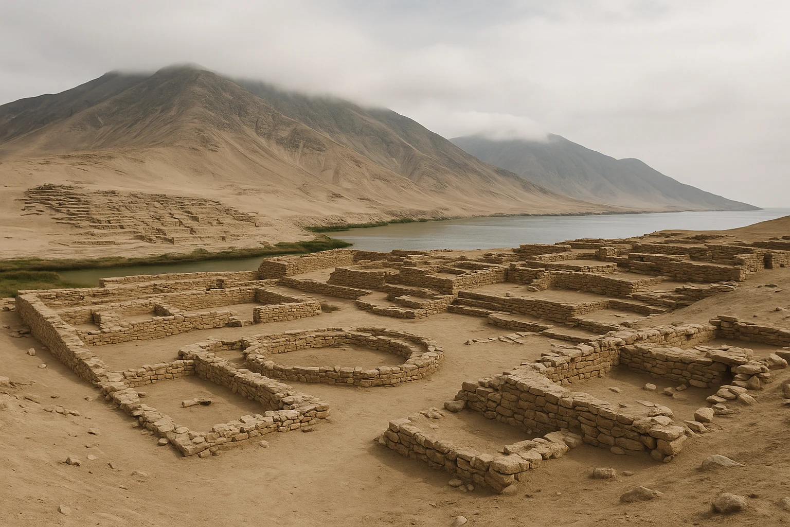
Just north of Lima, where dry desert earth meets reed-lined wetlands and the Pacific breeze, Bandurria, Peru overturns the usual storyline travelers carry into Andean archaeology. Most people expect monumental Peru to begin with the Inca, then maybe step backward to Moche or Chimu. Bandurria asks you to step far deeper, into a preceramic world where communities were already planning ceremonial spaces, coordinating labor, and shaping civic landscapes in the third millennium BCE. The first impression is quiet rather than theatrical: broad earthen rises, open sky, birds moving over the lagoon, and architecture that reveals itself slowly as your eyes adjust.
That slowness is the point. Bandurria is not a checklist site where you rush from one iconic stone facade to the next. It is a place that teaches you how early complexity looked on Peru’s coast before grand masonry and imperial iconography dominated the horizon. At Ancient Travels, we recommend Bandurria as one of the best timeline-reset destinations within reach of Lima, especially when paired with Caral-Supe and Aspero. This guide covers the site’s historical arc, what to prioritize among the monument sectors, practical transportation from Lima and Huacho, seasonal timing, and how to build a coherent day route that respects both archaeology and travel reality.
History: Wetland Horizons and Early Monumentality
Early settlement on the Huaura coast (c. 3500-3200 BCE)
Before Bandurria became a recognized ceremonial center, the Huaura coastal zone already supported communities that knew how to work multiple ecologies at once. Marine resources from the Pacific, wetland productivity near the lagoon, and access inland through valley corridors created a practical foundation for sustained settlement. Archaeological evidence from this wider region suggests people were experimenting with social coordination, food production strategies, and shared ritual spaces well before full-scale monumental construction. Bandurria grew from that setting rather than appearing suddenly. Its location, perched near productive waters but connected to overland routes, made it ideal for communities balancing local subsistence with broader exchange.
Monument construction and civic ritual (c. 3200-2600 BCE)
In this phase, Bandurria developed formal architectural sectors with platform mounds and organized public space, placing it firmly within the early monumental tradition of Peru’s central coast. The site’s built forms indicate planned labor and repeated construction episodes, not occasional ad hoc gatherings. Even where restoration and erosion complicate exact outlines, you can still read intentional alignment and controlled movement through ceremonial zones. Scholars often discuss Bandurria alongside early Supe Valley centers because both demonstrate that social complexity emerged through coordinated ritual and civic design, not simply through later state militarization. At Bandurria, monumentality appears as an evolving social contract materialized in earth and space.
Regional interaction with Norte Chico networks (c. 3000-2200 BCE)
Bandurria did not exist in isolation. Its chronology and architectural character overlap with broader Norte Chico developments, where inland and coastal communities appear to have exchanged goods, knowledge, and ceremonial practices across multiple valleys. Cotton, marine products, and crafted materials likely moved through these corridors, tying local economies to larger ritual-political systems. This networked view matters for visitors because it reframes Bandurria from “small local ruin” to active node in one of the earliest complex societies in the Americas. When you stand on the mound edges and look toward the wetland plain, it becomes easier to imagine how movement, visibility, and gathering were orchestrated in ways that linked coast and interior.
Transformation and changing occupation patterns (c. 2200-1800 BCE)
Like many early centers, Bandurria eventually shifted rather than vanishing in one dramatic collapse. Some sectors show changing use through time, and regional social priorities likely moved as environmental conditions, exchange routes, and settlement strategies evolved. Archaeologists caution against simplistic narratives of “rise and fall” here; the evidence often reflects gradual reconfiguration. Ritual spaces could be reused, repurposed, or symbolically maintained even as daily occupation changed. This long transition is one reason the site is historically rich despite its understated appearance. You are reading layers of adaptation, not a frozen monument built once and abandoned unchanged.
Rediscovery, protection, and modern archaeology (20th-21st centuries)
Although local communities long knew the mounds, Bandurria entered wider scholarly and public discussion through modern archaeological campaigns that clarified its antiquity and regional significance. Research and conservation have focused on mapping ceremonial architecture, stabilizing earthen sectors, and interpreting the site’s relationship to the lagoon and surrounding landscape. Public awareness has grown, but Bandurria remains less visited than Peru’s marquee destinations, which can be an advantage for thoughtful travelers. The modern chapter is still unfolding: each field season refines chronology, settlement interpretation, and conservation priorities in a context where fragile earthen architecture requires continuous care.
The Key Monuments: What to See at Bandurria
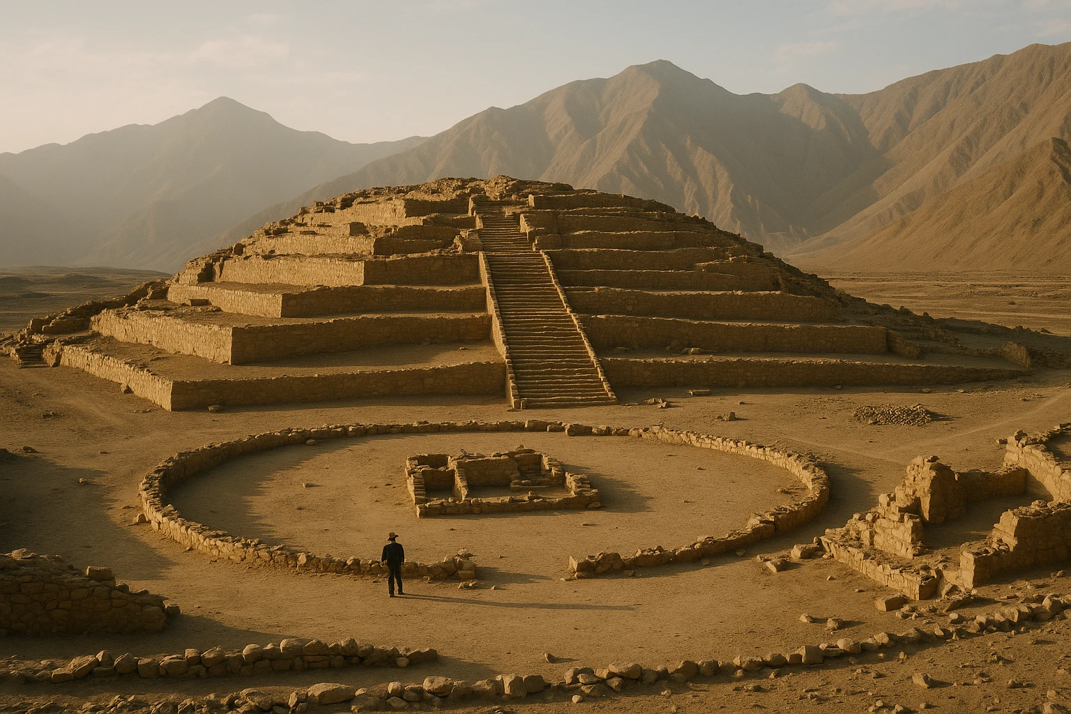
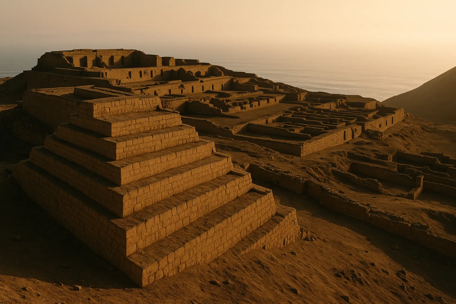
Principal platform mound sector
The main mound complex is the best starting point because it immediately shows Bandurria’s scale and planning logic. From ground level, the architecture can seem gentle and low compared with later stone centers, but step back and the massing becomes clear: layered earthworks, defined edges, and elevated ceremonial platforms positioned to structure attention. This is where labor coordination becomes visible. Building and maintaining these volumes required repeated collective effort, sustained over generations. Begin your walk by tracing approach lines rather than climbing too quickly; you will better understand how movement was directed and how authority may have been staged in relation to open gathering areas.
Ceremonial plaza and circulation spaces
Bandurria’s open spaces are essential for interpretation, not empty gaps between “real” monuments. The ceremonial plaza zones and circulation routes reveal how people assembled, processed, and viewed elevated architecture during public events. In practical terms, this is where social choreography becomes legible: where participants likely gathered, where leaders or ritual specialists could be seen, and how controlled movement reinforced shared order. Even fragmentary surfaces preserve this logic. Walk slowly and pause at transitions between open and elevated sectors. The design reads differently from each angle, and those shifts are part of how the site communicated meaning.
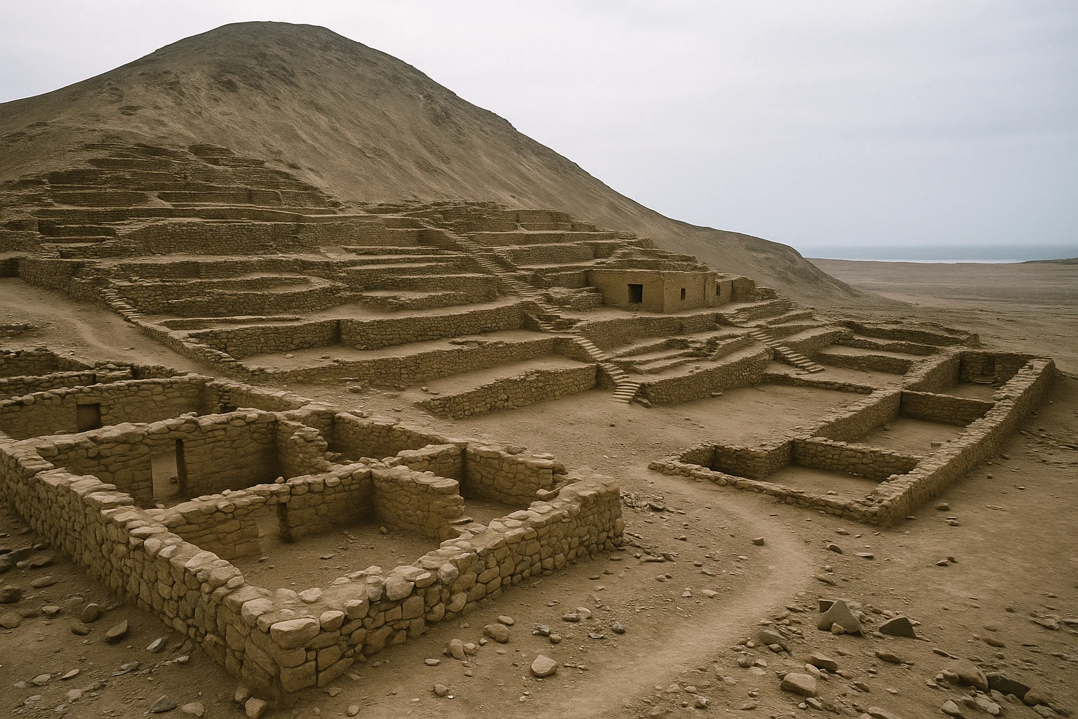
Secondary mounds and architectural clusters
Beyond the principal sector, secondary mound groups help explain Bandurria as a distributed ceremonial landscape rather than a single monument. These clusters vary in footprint and prominence, suggesting differentiated functions over time. Some appear to have worked as complementary ritual nodes, while others may have combined administrative, storage, or socially restricted activities tied to the ceremonial core. For visitors, these zones are where the site’s complexity emerges: not one pyramid dominating all else, but an integrated network of built forms with overlapping roles. If you have limited time, prioritize at least one secondary cluster to avoid leaving with an overly simplified impression.
Wetland-edge viewpoints
One of Bandurria’s defining features is its relationship to nearby wetlands, and designated viewpoints near the lagoon edge are as interpretively important as any mound. The environmental context explains why this location mattered: access to water, ecological diversity, and strategic visual command of movement corridors across the coastal plain. Standing at these points, you can read the site as landscape architecture as much as monument architecture. Birdlife, reeds, shifting light, and distant urban edges all reinforce the contrast between ancient planning and modern expansion. For photography, early morning usually offers cleaner texture and better comfort, while late afternoon brings warmer tones over the earthworks.
Site interpretation area and conservation zones
Bandurria’s interpretive and conservation sectors, where accessible, provide the modern key to understanding what you are seeing in the field. Earthen architecture is vulnerable, and stabilization methods can influence what appears “original” versus restored. Rather than treating barriers, marked paths, or protective interventions as obstacles, read them as part of the site’s current life. This is archaeology in progress, not a finished museum set. A short stop at interpretive panels or with a local guide can dramatically improve your visit, especially for chronology and comparisons with Caral-Supe. Ten minutes of context here saves an hour of guesswork among the mounds.
Getting There: Transportation and Access
Bandurria is reachable as a long but manageable day trip from Lima, and easiest of all if you stage from Huacho.
From Lima
The standard route heads north on the Pan-American Highway toward Huacho, then continues to the Bandurria sector near the wetland zone.
- Organized day tour: Usually the smoothest option for first-time visitors, especially if combining with Caral or Aspero. Expect around 11-13 hours total, with prices commonly near S/540-S/1,000 ($145-$269 USD) depending on group size and whether service is shared or private.
- Intercity bus + taxi: Take a northbound bus to Huacho (often 2.5-3.5 hours), then continue by taxi to the site area (about 15-30 minutes depending on pickup point and traffic). Combined transport often lands near S/75-S/150 ($20-$40 USD) before entry fees.
- Rental car or private driver: One-way road time is often 2.5-3.5 hours from Lima districts, but city exits can add delay. This option gives the most flexibility if you want to add nearby archaeology or coordinate exact photo windows.
From Huacho
Huacho is the nearest practical hub and makes Bandurria much easier to visit at a comfortable pace.
- Taxi direct: The quickest transfer, commonly around S/20-S/40 ($5-$11 USD) round trip depending on waiting and negotiation.
- Local transport + short taxi connection: A budget route that can work for flexible travelers but may involve schedule uncertainty.
- Prearranged local driver: Best if you plan to continue toward Supe corridor sites on the same day.
Admission and Hours
Admission and operating windows can shift with conservation schedules, local staffing, and holiday periods, so confirm current details before departure. As a planning baseline, budget about S/10-S/20 ($3-$5 USD) and bring cash in soles. Daytime access is typical, often with last entry in late afternoon rather than near closing. Because shade is limited, aim for early morning or late afternoon visits. If you are photographing earthen textures, the lower-angle light in those windows is materially better than midday glare.
When to Visit: Seasonal Considerations
Spring (September-November)
Spring is one of the strongest periods for Bandurria, with mild-to-warm temperatures often around 18-25°C (64-77°F). Crowds are generally moderate outside holiday spikes, and conditions support longer walks across exposed sectors without intense heat stress. Visibility over the wetland and coastal plain is often good. For most travelers, this is an ideal blend of comfort and clarity.
Summer (December-March)
Summer brings stronger sun and warmer midday conditions, commonly around 22-30°C (72-86°F), sometimes higher on windless days. Weekend domestic traffic north of Lima can increase transfer times, and noon light can flatten earthen relief in photos. Start early, carry extra water, and plan your main monument circuit before midday whenever possible.
Autumn (April-May)
Autumn is another excellent window and often the best all-around season for balanced weather, with temperatures frequently around 19-27°C (66-81°F). Crowd pressure usually eases compared with summer weekends, and the site can feel calmer for slower interpretation. If you care about both comfort and photography, autumn mornings are especially rewarding.
Winter (June-August)
Winter along Peru’s central coast is cooler and can be hazier, often around 15-22°C (59-72°F). Overcast mornings are common, but reduced heat makes walking easier and low crowds create a quieter site experience. Bring a light layer for early starts and expect softer, less contrast-heavy light. Winter is fully viable; it simply offers a different visual mood.
Combining Bandurria with Huacho and the Caral Corridor
Bandurria works best as part of a coherent north-coast archaeology day, not a rushed standalone stop inserted between unrelated errands. From Lima, a practical sequence begins with departure around 5:30 AM, reaching the Huacho area by 8:30-9:00 AM depending on traffic. Start at Bandurria while temperatures are still manageable, taking about two hours to cover the principal mounds, circulation spaces, and at least one wetland viewpoint. By 11:30 AM, transition toward lunch in Huacho, where seafood-focused menus make sense before an afternoon inland shift.
If your energy and daylight allow, continue toward Caral-sector archaeology after lunch, aiming to arrive around 1:30-2:00 PM. This creates a valuable interpretive contrast: Bandurria’s wetland-edge coastal ceremonial landscape in the morning, then Supe Valley monumentality in the afternoon. Leave enough buffer for return traffic and plan to be back in Lima between 8:00 PM and 9:30 PM.
A less exhausting option is to overnight in Huacho. In that rhythm, you can visit Bandurria at opening, continue north or inland without rush, and treat the region as a two-day archaeological corridor rather than a marathon transfer day. This pacing also improves your chances of catching better light at both sites.
For travelers with very limited time, Bandurria alone still rewards a focused half day, but context is everything. Even brief pre-reading or guide support makes a major difference because the site’s significance lies in systems, chronology, and landscape relationships more than dramatic single monuments.
Practical Information
What to bring
- Sun protection: Hat, sunscreen, and sunglasses are essential because shade is minimal on exposed sectors.
- Water: Carry at least 1-1.5 liters per person, more in summer.
- Footwear: Closed shoes with good grip are best for compacted earth, loose gravel, and uneven edges.
- Cash in soles: Useful for entry fees, taxis, and small local purchases.
- Camera or phone battery pack: You may spend more time than expected on wide landscape compositions.
Etiquette and site care
Bandurria’s architecture is fragile. Stay on marked paths, avoid climbing unapproved sectors, and follow on-site guidance from staff or guides. Do not remove fragments or natural materials from the area. Quiet observation is part of respecting both the archaeology and nearby communities.
Accessibility
Access may be challenging for visitors with reduced mobility because routes include uneven surfaces, mild slopes, and limited assistive infrastructure. Some viewpoints are easier than others, but a fully barrier-free circuit is unlikely. If accessibility is a priority, contact a local operator in advance to discuss current path conditions and possible accommodations.
Why Bandurria Matters
Bandurria matters because it restores proportion to Peru’s ancient past. It reminds you that complex social life on this coast did not begin with imperial capitals or cut-stone citadels. It began with communities that learned to coordinate labor, ritual, and ecology in places where sea, wetland, and desert met. The monuments are quieter here, but the implications are enormous: planned ceremonial landscapes were already emerging in the Americas while much of the story most travelers know had not yet begun.
It also matters because the site teaches a better way to travel. Instead of chasing only the loudest icon, Bandurria rewards attention, patience, and context. You leave understanding that early civilization can be subtle in form and still revolutionary in meaning. If Caral gives you scale and chronology, Bandurria gives you texture: the environmental intelligence, social choreography, and long continuity that made those first urban experiments possible.
Quick Facts
| Attribute | Details |
|---|---|
| Location | Near Huacho, Lima Region, Peru |
| Ancient Name | Bandurria (preceramic coastal ceremonial center) |
| UNESCO Status | Not independently inscribed; part of the wider Norte Chico cultural landscape |
| Established | c. 3200 BCE ceremonial settlement |
| Distance from nearest hub | ~10 km from central Huacho (about 20-30 min by road) |
| Entry Fee | Typically around S/10-S/20 ($3-$5 USD), verify locally |
| Hours | Daytime access; seasonal schedules may vary |
| Best Time | Spring and autumn mornings |
| Suggested Stay | 1.5-2.5 hours |
| Primary Highlights | Platform mounds, ceremonial spaces, wetland-edge viewpoints |
Explore More Peru
- Caral-Supe: The foundational inland city of the Norte Chico world and a natural pairing with Bandurria.
- Aspero: A coastal ceremonial center that complements Bandurria’s wetland-edge context.
- Pachacamac: A long-lived pilgrimage complex south of Lima with multi-era religious architecture.
Plan your wider route with our Peru Ancient Sites Guide and continue your planning in How to Plan a Multi-Site Peru Itinerary.
Frequently Asked Questions
How much time should I plan at Bandurria?
Plan 1.5 to 2.5 hours on site for a full circuit of the principal mounds, viewpoints, and interpretive areas. If you are visiting from Lima in one day, total travel time makes this a long excursion, so start early. Pairing Bandurria with one additional site like Caral usually turns the day into a 11-13 hour itinerary.
Is Bandurria older than Caral-Supe?
Bandurria and Caral belong to the same broad preceramic world, and both have very early dates in the third millennium BCE. Archaeologists continue refining chronology as new samples are studied, so it is better to see Bandurria as a complementary center rather than a simple older-versus-younger ranking. Visiting both helps you understand the coastal and valley dimensions of early Andean complexity.
How do I get to Bandurria from Lima?
The simplest option is a guided day tour or private driver via the Pan-American Highway north toward Huacho. Independent travelers can take an intercity bus to Huacho and continue by taxi to the site zone. Expect roughly 2.5-3.5 hours one way depending on traffic and departure point in Lima.
What are the admission costs at Bandurria?
Admission policies can vary with conservation and staffing, but travelers should budget around S/10-S/20 (about $3-$5 USD) and carry cash in soles. Some combined tours include entry in the package price. Always confirm current rates locally before departure.
What will I actually see at Bandurria?
You will see earthen platform mounds, ceremonial sectors, circulation spaces, and a dramatic setting beside coastal wetlands near Huacho. The architecture is subtle compared with later stone empires, but historically crucial for understanding early urban planning on the central Peruvian coast. The landscape context is part of the monument.
Is Bandurria safe for tourists?
Yes, Bandurria is generally safe during daytime visits with normal precautions. Use registered transport, keep valuables discreet, and stay on marked paths or guided routes. Because the area is exposed, sun protection and hydration are just as important as standard security awareness.
Nearby Ancient Sites
Caral-Supe Peru Guide 2026: Sacred Pyramids & the First Andean City
Norte-Chico-CaralVisit Caral-Supe in Peru, the oldest known city in the Americas, with practical transport from Lima,...
Aspero Peru Guide 2026: Norte Chico Pyramids & Caral Coast
Norte-Chico-CaralVisit Aspero in Peru to see Norte Chico pyramids, plazas, and elite temples, with practical tips for...
Pachacamac Peru Guide 2026: Oracle Temple, Pilgrimage Roads & Lima Coast
Lima-Wari-Ychsma-IncaExplore Pachacamac near Lima: ancient oracle temples, multi-civilization coastal history, practical ...