Quick Info
Curated Experiences
Coba Ruins and Cenote Day Tour
The jungle at Coba is not background scenery. It is the defining fact of the place. Where Tulum perches on a Caribbean cliff and Chichen Itza spreads across flat, groomed lawns, Coba hides inside a canopy so dense you hear the structures before you see them — the echo of your footsteps off stone walls still wrapped in tree roots, the sudden silence when the path opens onto a clearing and a pyramid face rises forty meters above you. This is what a Maya city actually felt like: not a collection of monuments arranged for display, but an engineered landscape woven into forest that has spent a thousand years trying to reclaim it.
Coba sprawls across roughly 80 square kilometers of lowland jungle, its temple groups connected by the longest network of sacbeob (raised stone causeways) in the Maya world. You do not walk Coba the way you walk most archaeological sites, moving between structures in a tidy loop. You traverse it — on foot, by rented bicycle, or on a tricycle pedaled by a local guide — covering real distance between widely separated complexes that once formed the neighborhoods of a city rivaling Chichen Itza in size and influence. The scale is the point. Most visitors come for the pyramid. The ones who return come for the journey between structures.
If you have visited only the coastal ruins or the manicured showpieces of the northern Yucatan, Coba will recalibrate your sense of what Maya civilization built and how it operated. This was not a ceremonial center. It was a city of perhaps 50,000 people, positioned at the junction of five inland lakes, connected to the wider Maya world by roads its engineers carved straight through the limestone forest.
Historical Context
Coba’s origins reach back to at least 100 BCE, but the city rose to genuine regional power between 600 and 900 CE, the Late Classic period that produced the Maya world’s greatest architectural and intellectual achievements. Its location was strategic in a landscape where water was scarce: five shallow lakes cluster near the site center, a rare concentration in the porous limestone of the northern Yucatan where rivers run underground and surface water is locked in cenotes. Control of those lakes gave Coba agricultural capacity and a reliable water supply that most competing cities lacked, and the political leverage that followed was immense.
At its peak, Coba may have housed 50,000 residents spread across residential platforms, temple complexes, and market areas connected by over fifty sacbeob radiating outward from the city core. The longest of these causeways stretches over 100 kilometers to the site of Yaxuna, near modern-day Chichen Itza — not a footpath but an engineered limestone highway, elevated above the surrounding terrain, surfaced with white plaster, and wide enough for processions and trade caravans. No other Maya city invested this heavily in physical road infrastructure. The sacbe network made Coba a hub, connecting it to satellite communities and rival cities in a web of commerce, tribute, and political alliance that shaped the eastern Yucatan for centuries.
The rivalry between Coba and Chichen Itza defined Late Classic politics in the region. As Chichen Itza’s power grew after 800 CE, drawing on Toltec-influenced military and architectural innovations, Coba’s influence waned. By 1000 CE, the city had lost its dominant position, though it was never entirely abandoned. Postclassic populations continued to occupy and modify structures through the 15th century, and pilgrims visited the site well into the Spanish colonial period. The jungle, however, had already begun its slow reconquest, and by the time archaeologists surveyed the area in the 1920s, most of Coba’s structures were buried under centuries of forest growth.
Only a small fraction of Coba has been excavated. Dozens of mapped structures remain covered in vegetation, their outlines visible as mounds beneath the canopy. This is both a limitation and part of the site’s appeal: you are walking through a city that is still, in the most literal sense, being uncovered. New structures continue to emerge from the jungle as INAH (Mexico’s National Institute of Anthropology and History) slowly expands the excavation perimeter, and what visitors see today represents only a fraction of what existed when the city was at its height.
The sacbe network is central to understanding why Coba matters beyond its individual structures. These were not footpaths. They were engineered highways: elevated above the surrounding terrain on a rubble foundation, surfaced with white stucco that would have gleamed in moonlight, and wide enough for multiple people to walk abreast. The sacbe connecting Coba to Yaxuna was a political statement — a 100-kilometer road binding a distant city into Coba’s sphere of influence through physical infrastructure. The Romans built roads for the same reason, and the comparison is not casual. Coba’s investment in connecting infrastructure reveals a city that understood power as a function of linkage, not just monumental architecture.
What to See
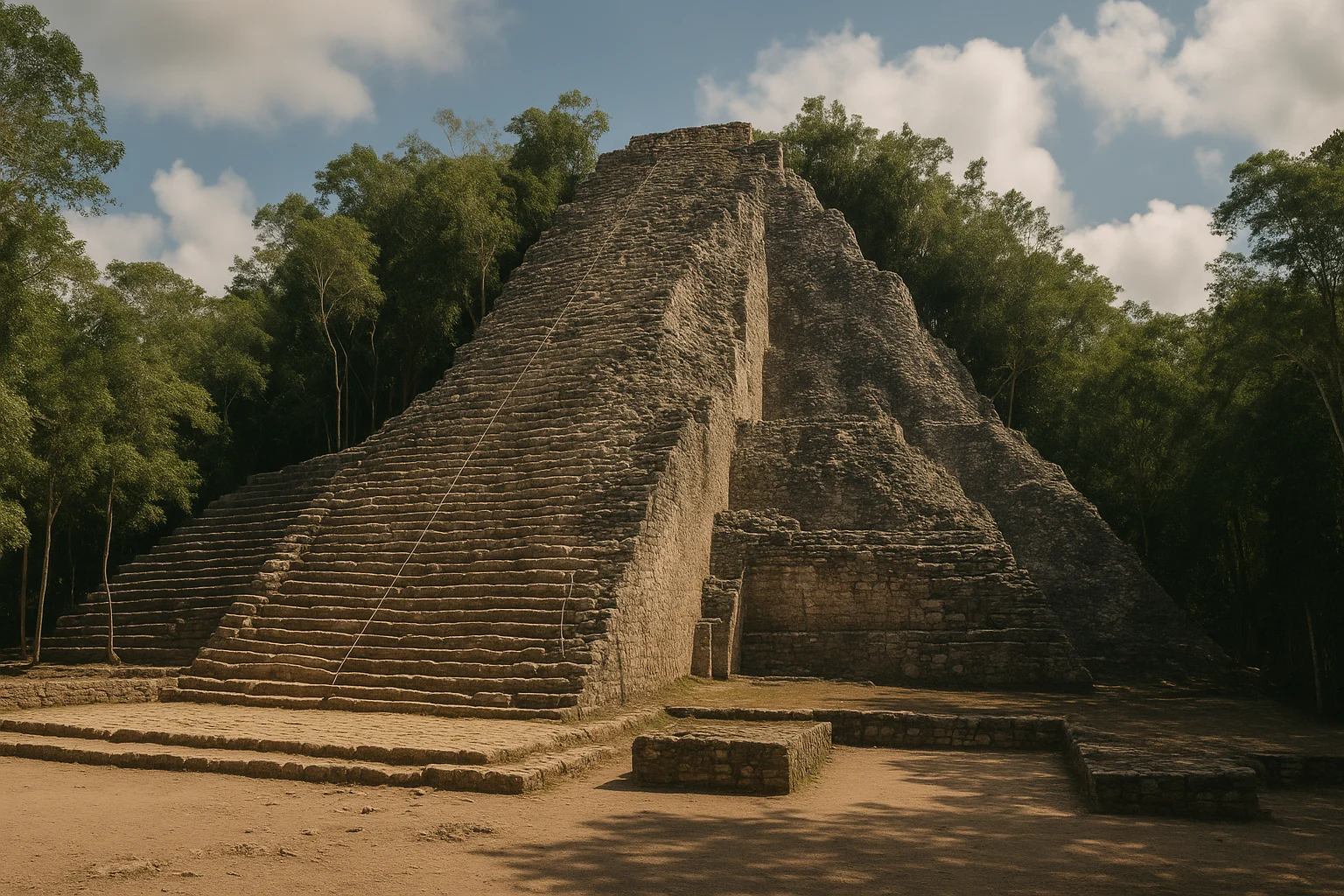
Nohoch Mul Pyramid
The tallest climbable pyramid in the Yucatan Peninsula rises 42 meters above the jungle floor, and the ascent is 120 steep, rough-cut limestone steps with a single rope handline for support. The pitch is aggressive enough that you will use your hands in places, and the descent demands more care than the climb. But the summit view is the most honest perspective available on what lowland Maya civilization looked like: unbroken green canopy stretching to every horizon, punctuated only by the tops of distant temple mounds breaking the treeline. No modern structures are visible. On clear mornings, you can count the peaks of unexcavated pyramids rising from the forest, each one marking a structure that has not been touched since the jungle took it.
Nohoch Mul dates to the Postclassic period and bears a carved diving figure above its doorway similar to those at Tulum, linking the two sites in the coastal Maya tradition. The diving god motif — a figure descending headfirst, often associated with the setting sun or the planet Venus — appears across Late and Postclassic Maya sites in the region, and its presence here connects Coba’s latest builders to a wider network of religious and artistic exchange. Arrive before 9:00 AM to climb with fewer people on the steps and cooler temperatures on the exposed stone face. The climb takes 10-15 minutes at a steady pace; allow time to rest at the summit and absorb the view before descending.
The Coba Group
The cluster nearest the entrance contains some of the site’s oldest construction, including La Iglesia — a 24-meter pyramid that offers a less strenuous climb than Nohoch Mul with similarly rewarding canopy views. The Coba Group also includes a well-preserved ball court, one of two at the site, where the sloping stone walls concentrate sound in ways that suggest deliberate acoustic design. Start your visit here to orient yourself before committing to the longer causeway walks.
The stelae scattered around the group’s base are among the site’s most important archaeological features. They record dates in the Long Count calendar — the most precise timekeeping system in the pre-Columbian Americas — and several reference events from Coba’s political history that archaeologists are still working to decode. Stela 1, near the base of La Iglesia, bears one of the longest known Maya calendar inscriptions, reaching back to a mythological date billions of years in the past, a reminder that the Maya conceived of time on scales no other pre-modern civilization attempted.
Conjunto de las Pinturas (The Paintings Group)
A smaller temple complex roughly 1.5 kilometers from the entrance, reached via Sacbe 3, the Paintings Group retains traces of original painted stucco on its upper facade. The color has faded, but remnants of red, blue, and green plaster are still legible — a corrective to the bare-stone impression most Maya ruins leave. These buildings were once vividly polychrome, every surface coated in plaster and pigment, and the Paintings Group is one of the few places at Coba where that original skin survives.
The pyramid here is smaller and less dramatic than Nohoch Mul, but the carved panels on its stairway, depicting bound captives and scenes of ritual authority, are among the site’s most detailed sculptural works. The carved lintels over the temple doorways at the summit are also noteworthy, showing figures in ceremonial dress performing what appear to be bloodletting rituals. This stop rewards a detour that many visitors skip, and the relative quiet of the Paintings Group makes it a welcome contrast to the more trafficked Nohoch Mul path.
The Sacbe Walks
Do not treat the causeways as dead time between structures. Sacbe 1, the main route connecting the Coba Group to Nohoch Mul, is itself an archaeological feature — a raised limestone road running straight through dense forest for roughly two kilometers. The surface is original Maya engineering: compacted limestone rubble topped with plaster, elevated a meter or more above the surrounding terrain to manage flooding and assert the road’s permanence. Walking it is the closest you will get to experiencing Coba the way its inhabitants did: moving through a built landscape where the infrastructure is as deliberate as the temples.
The wildlife along the sacbeob adds another dimension to the experience. Howler monkeys are common in the canopy overhead, their territorial calls audible from hundreds of meters away. Toucans, coatimundis, and spider monkeys are regularly spotted crossing between trees, and the jungle floor hosts an array of tropical butterflies and lizards. Coba is one of the few archaeological sites in the Yucatan where the natural environment remains genuinely wild, and the combination of ancient engineering and living forest gives the causeways an atmosphere that no cleared or groomed site can replicate.
Macanxoc Group
The least-visited major complex at Coba sits at the end of Sacbe 2, about a kilometer east of the entrance. Macanxoc contains the site’s most important collection of carved stelae — upright stone monuments recording royal histories, astronomical observations, and Long Count dates that reach back to the mythological origins of the Maya cosmos. Several stelae here bear dates that reference events millions of years in the past, a reminder that the Maya conceived of time on scales that dwarf any other pre-modern civilization. Stela 6 at Macanxoc contains what may be Coba’s most complete surviving royal narrative, though erosion has rendered parts of the text difficult to decipher.
The group sees far fewer visitors than Nohoch Mul, and the quiet is striking. If you have time for only one secondary complex, choose this one over the Paintings Group — the stelae collection alone justifies the walk, and the solitude of the path gives you a better sense of what Coba felt like before the tour buses started arriving.
The Lakes
Coba’s five lakes — Coba, Macanxoc, Sacalpuc, Xkanha, and Yaxlaguna — are unusual features in the Yucatan, where the porous limestone swallows surface water into underground rivers and cenotes. The lakes cluster near the site center and were the resource that made the city possible: freshwater for agriculture, domestic use, and the dense population that no cenote-dependent settlement could sustain at comparable scale. Lake Coba is visible from the entrance area, and Lake Macanxoc lies near the stelae group that shares its name. The lakes are not swimming spots, but their presence along the sacbe walks adds a dimension to the landscape that distinguishes Coba from every other inland Maya site in the northern Yucatan.
Timing and Seasons
The site opens at 8:00 AM and closes at 5:00 PM daily, with last entry around 4:00 PM. Arrive at opening. This is not generic advice — it is the single most important logistical decision for a Coba visit. By 10:00 AM, tour buses from Cancun and Playa del Carmen begin arriving in volume, and the path to Nohoch Mul becomes a single-file procession that can add 30-45 minutes of waiting time to the climb. Early arrivals have the causeways largely to themselves, and the climbing steps at Nohoch Mul are empty enough to ascend at your own pace. The difference between an 8:00 AM arrival and a 10:30 AM arrival is not marginal — it is the difference between an intimate archaeological experience and a crowded tourist attraction.
November through March is the best window for visiting, with drier air, lower humidity, and morning temperatures in the mid-70s°F (23-25°C). Even in “dry season,” afternoon humidity under the canopy is substantial, and you will sweat more than the temperature alone suggests. April through June brings the worst combination of heat and humidity, with temperatures reaching the low 90s°F (32-34°C) and jungle air that feels like breathing through a warm, wet cloth. The rainy season from July through October brings afternoon downpours that cool the air but turn the sacbe surfaces slippery and the dirt bicycle paths muddy. Morning visits remain viable year-round.
Midday is the worst time under any conditions. The canopy traps humidity, the shade provides no real relief from the heat, and the climbing surfaces at Nohoch Mul become genuinely uncomfortable in direct sun. Plan to finish your visit by noon if possible, or take a cenote break in the early afternoon and return for a final hour before closing. The cenotes near Coba — particularly Cenote Choo-Ha and Cenote Tamcach-Ha, both within a 10-minute drive of the site entrance — offer swimming in cool underground freshwater that makes the ideal midday reset between archaeological stops. If you plan to visit a cenote after the ruins, bring a swimsuit, towel, and waterproof bag for your camera. The cenotes charge 75-100 pesos admission each and have changing facilities.
Tickets, Logistics, and Getting There
Admission to Coba costs approximately 80 pesos ($4 USD) as of 2026, though INAH periodically adjusts prices. A separate fee of 60 pesos ($3 USD) is charged for video cameras. Sunday admission is free for Mexican nationals and residents, which increases crowds. Cash is safest at the entrance; card acceptance is unreliable. There is no advance booking system — tickets are sold at the gate on arrival. The entrance area includes restrooms, a small parking lot, bicycle rental stands, and a cluster of vendor stalls selling water, snacks, and souvenirs.
From Tulum, the drive takes about 45 minutes on a well-paved two-lane road through flat jungle terrain. Colectivos (shared vans) run from Tulum’s colectivo stand on the main highway and cost roughly 60 pesos ($3 USD) each way, departing when full. From Cancun or Playa del Carmen, budget 2 to 2.5 hours driving time each way. Most organized tours from the Riviera Maya hotels run $60-90 per person and include transport, a guide, entrance fees, and a cenote stop. If you are renting a car, the drive is straightforward and parking at the site costs 50 pesos. The road from Tulum to Coba is clearly signed, flat, and in good condition; it passes through the small town of Macario Gomez, where a few roadside restaurants offer solid Yucatecan food at local prices.
Inside the site, bicycle rentals are available near the entrance for around 60 pesos and cut transit time between structure groups substantially. The riding surface is packed dirt that gets muddy after rain, and there are no gears — just single-speed cruisers. Alternatively, tricycle taxis pedaled by local guides cost 150-200 pesos for a round-trip circuit of the main structures, a good option if you prefer to save your energy for climbing or if the heat is too intense for sustained walking. Walking the full circuit on foot takes 3 to 4 hours at a moderate pace; bicycles cut that to about 2 hours.
Practical Tips
- Bring significantly more water than you think you need. The jungle humidity is relentless, and shade does not equal cool. One liter per person is a minimum; bring two if visiting in the warmer months.
- Wear shoes with solid grip and ankle support. The sacbe surfaces are uneven limestone, the Nohoch Mul steps are rough-cut stone, and the bicycle paths have exposed roots and rocks.
- Bug spray is essential, particularly during the rainy season. Mosquitoes are aggressive near the lake margins and in shaded areas along the sacbeob.
- The site has minimal infrastructure. There are basic restrooms near the entrance and a few vendor stalls selling water, snacks, and souvenirs outside the gate, but nothing inside the archaeological zone.
- If you rent a bicycle, lock it at the designated racks near each structure group. Theft is rare but the site is large enough that a lost bike costs real time.
- Bring a small flashlight or use your phone light if you want to examine the darker interior chambers at the Paintings Group — the carved details are hard to see in low light.
- A hat is essential for the exposed pyramid summits, even if you spend most of your time under canopy shade on the causeways.
- There is no cell service inside the archaeological zone. Download any maps or reference material before entering.
- If visiting with children, the bicycle option is excellent for keeping them engaged over the long distances. The tricycle taxis also accommodate families.
Suggested Itinerary
Half-day visit (3 to 3.5 hours):
Arrive at 8:00 AM. Walk or bike directly to Nohoch Mul via Sacbe 1 (30 minutes on foot, 15 by bike). Climb the pyramid and spend 20 minutes at the summit. Descend and explore the surrounding platforms (15 minutes). Return along Sacbe 1, stopping at the Paintings Group if time allows (20-minute detour). Finish at the Coba Group near the entrance, visiting La Iglesia and the ball court (30 minutes). Exit by 11:30 AM, in time to reach a cenote for a midday swim before the heat peaks. Cenote Choo-Ha, 7 kilometers from the site entrance, is the best nearby option — a cavern cenote with a staircase descent into cool blue water.
Extended visit (4 to 5 hours):
Follow the half-day route but add the Macanxoc Group via Sacbe 2 after the Coba Group (45-minute round trip on foot). This adds the site’s best stelae collection and a stretch of quieter causeway that most visitors never see. Budget extra time to walk at least one sacbe segment slowly, paying attention to the engineering of the road surface and the wildlife in the canopy overhead. Finish by noon for a cenote and lunch in Tulum. If you are driving back to Tulum, the town of Macario Gomez on the return road has a few roadside restaurants where the cochinita pibil (slow-roasted pork) is excellent and inexpensive.
Nearby Sites
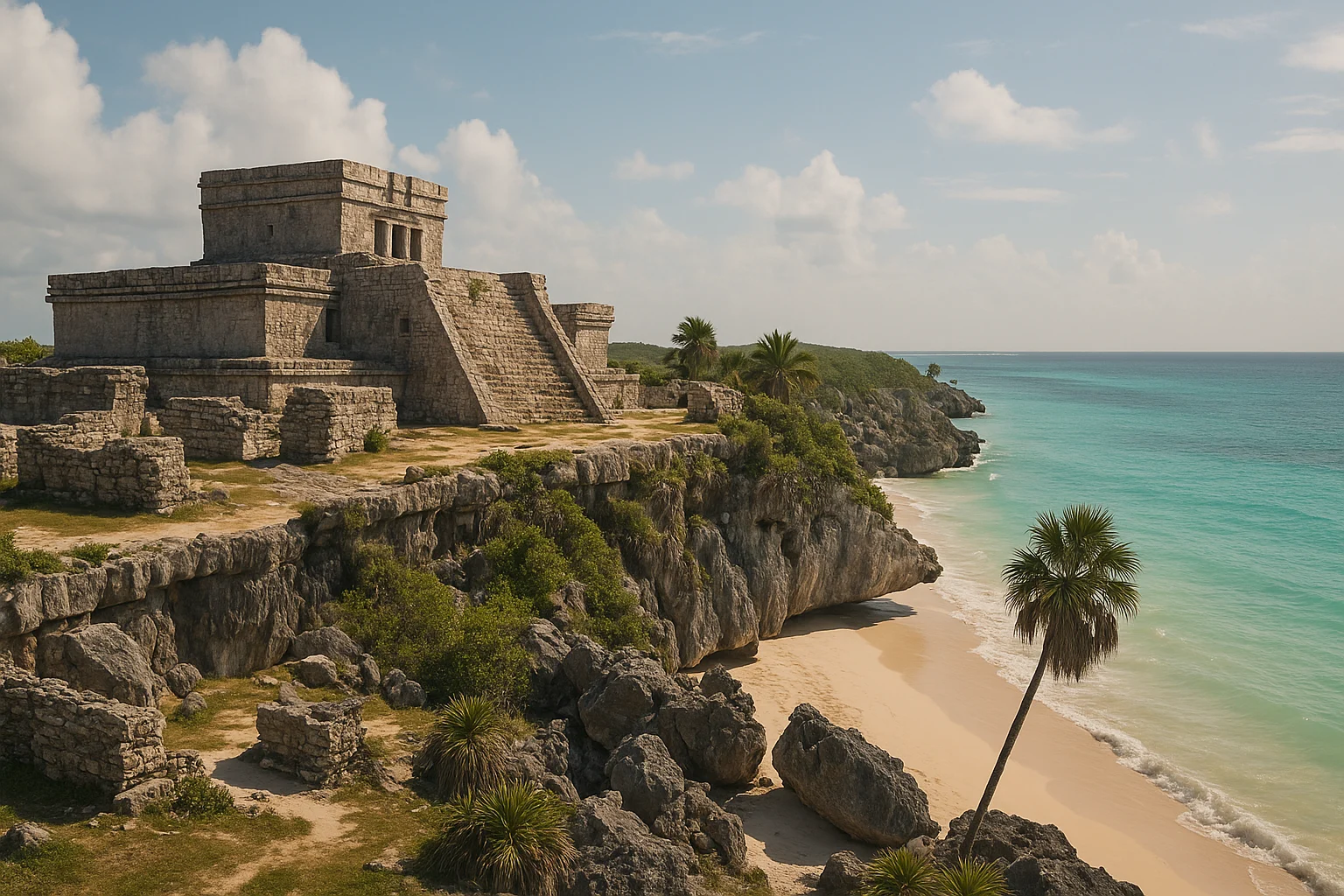
Coba works best as the inland counterpart to Tulum, under an hour south by car. Where Coba is a sprawling jungle capital connected by limestone highways, Tulum is a compact coastal trading port perched on a Caribbean cliff. Together, they tell a more complete story of Maya civilization in Quintana Roo than either does alone. Visit Tulum first for its Caribbean setting and compact scale, then contrast it with Coba’s forest sprawl. The drive between the two sites takes about 45 minutes and passes through flat jungle terrain with occasional villages.
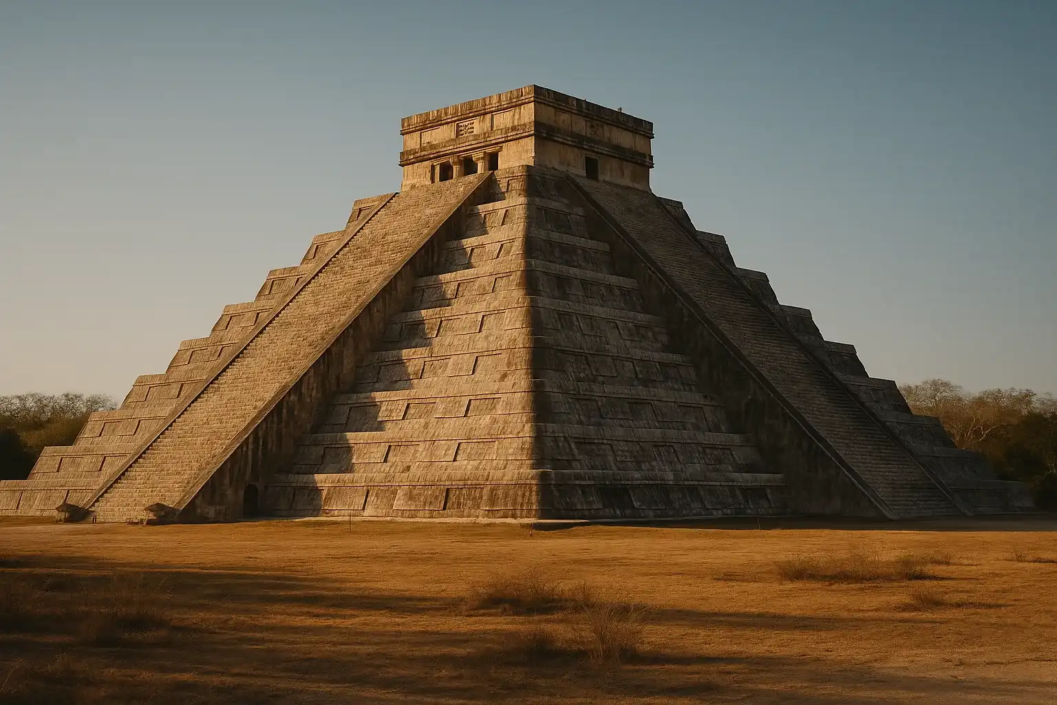
For the Yucatan’s most famous site, Chichen Itza lies about 2.5 hours northwest. The two cities were political rivals during the Late Classic period, and seeing both illuminates the power dynamics that shaped the region. Chichen Itza is more restored and far more crowded, but its architectural ambition — particularly the great ball court and the pyramid of Kukulkan — is undeniable. The contrast between Chichen Itza’s open, managed plazas and Coba’s jungle-wrapped causeways makes each site more legible in light of the other.
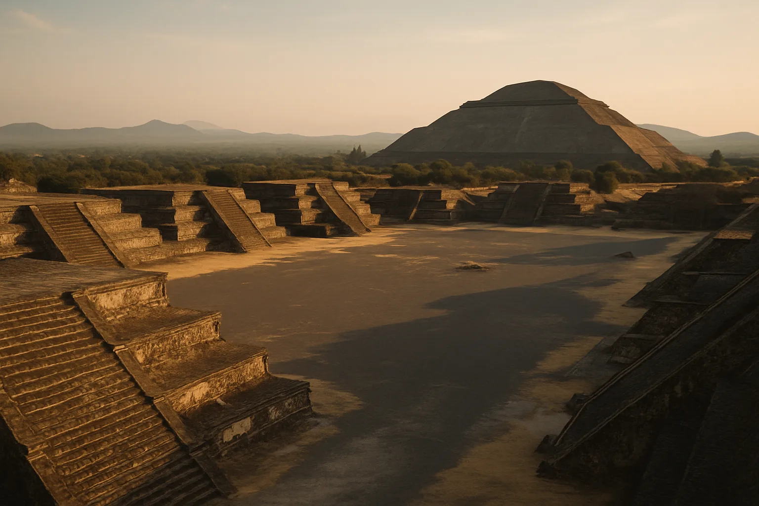
For the deepest Mesoamerican chronology, tie your itinerary to Teotihuacan near Mexico City — a city that predates Coba by centuries and whose cultural influence rippled through every subsequent Mesoamerican civilization, including the Maya. Teotihuacan requires a domestic flight from Cancun to Mexico City, but the connection enriches the entire trip.
The cenotes near Coba also deserve mention as standalone destinations. Cenote Choo-Ha (7 km from the site entrance) is a cavern cenote with a staircase descent into cool blue water. Cenote Tamcach-Ha, nearby, has a higher platform for jumping. Both charge 75-100 pesos admission and are easily combined with a morning at Coba for a rewarding full half-day. Cenote Multum-Ha, the deepest of the three, is the least visited and the most atmospheric.
Final Take
Coba does not photograph as dramatically as Chichen Itza or frame as neatly as Tulum against the Caribbean. Its power is experiential — the long walks, the jungle sounds, the sudden appearance of stone through green canopy. It is the antidote to the roped-off, overcrowded Maya ruin experience. The jungle is close, the paths are long, and the structures emerge from the canopy rather than sitting on manicured lawns. The sacbe network alone makes this site unlike anything else in the Yucatan — not just temples, but the roads that connected a living city to a wider world. Arrive at opening, climb Nohoch Mul before the heat and the crowds arrive, and walk at least one full causeway to understand what made this place work. You will leave with a sense of scale and an understanding of Maya urban ambition that no coastal site in the Riviera Maya can match.
Discover More Ancient Wonders
- Tulum: Clifftop Maya trading post overlooking the Caribbean, under an hour from Coba
- Chichen Itza: The iconic Yucatan pyramid and Coba’s great political rival
- Teotihuacan: The ancient metropolis near Mexico City that predated and influenced Maya civilization
- Explore more destinations in our Mexico Ancient Sites Guide
Quick Facts
| Attribute | Details |
|---|---|
| Location | Tulum, Quintana Roo, Mexico |
| Country | Mexico |
| Region | Quintana Roo |
| Civilization | Maya |
| Historical Period | c. 600-1500 CE |
| Established | c. 600 CE |
| Admission | ~80 pesos ($4 USD) |
| Hours | 8:00 AM - 5:00 PM daily |
| Time Needed | 2.5 - 4 hours |
| Coordinates | 20.4897, -87.7343 |
Frequently Asked Questions
How long do you need at Coba ruins?
Most travelers spend 2 to 3 hours in the archaeological zone, depending on pace and weather conditions.
Is Coba worth visiting from Tulum?
Yes. It is one of the easiest inland archaeology day trips from Tulum and offers a different experience from coastal sites.
Can you do Coba and Tulum in one day?
Yes, but it can feel rushed. Most travelers get better pacing by focusing on one major site per half-day.
Nearby Ancient Sites
Tulum Travel Guide 2026: Ruins, Beach Access, and Smart Visit Timing
MayaPlan a better Tulum ruins visit with opening-hour strategy, practical logistics from Cancun or Playa...
Chichen Itza Travel Guide 2026: Maya Secrets, Sacred Cenote, and Smart Timing
MayaChichen Itza stands as the most visited ancient site in Mexico, showcasing the architectural genius ...
Teotihuacan Mexico Travel Guide 2026: Pyramids, Mysteries & Day Trips
TeotihuacanoTeotihuacan, the 'birthplace of the gods,' remains Mesoamerica's most influential ancient city. This...