Quick Info
Curated Experiences
Dujiangyan & Mount Qingcheng Day Tour from Chengdu
Private Chengdu to Dujiangyan Tour
Sichuan Cultural Heritage Tours
Dujiangyan sits where the mountains release the Min River onto the Chengdu Plain—a borderland of furious water and extraordinary ingenuity. For nearly a thousand years before Li Bing arrived here in 256 BCE, the Min regularly burst its banks, drowning crops and villages with seasonal indifference. In the dry months it ran shallow and sluggish, leaving the plain parched. Li Bing, appointed governor of Shu by the Qin king who would soon unify all of China, saw not a problem but a puzzle—and he solved it without dams, without concrete, without anything more permanent than split bamboo, stone, and a careful reading of water’s own nature.
The result was Dujiangyan: an interlocking cascade of weirs, levees, and channels that divides and tames the Min River while leaving it fundamentally alive. Two and a half millennia later, it still irrigates more than 668,000 hectares of farmland and supplies water to tens of millions of people across Sichuan Province. No other hydraulic work of comparable age functions anywhere on Earth. UNESCO recognized it in 2000 alongside the adjacent Taoist mountain of Qingcheng Shan, and engineers from the Netherlands, Brazil, and India have traveled here to study what Li Bing understood before the Roman Empire reached its peak. To stand on the Fish Mouth Levee and watch the Min surge past on both sides is to understand, in a way no textbook manages, what it means to work with nature rather than against it.
A History Written in Water
The Min River originates in the alpine meadows of the Minshan range on the eastern edge of the Tibetan Plateau. By the time it reaches Dujiangyan—historically called Guan County—it has fallen thousands of meters in elevation and carries a vast volume of fast, sediment-heavy water. The Shu people who had settled the Chengdu Plain below had no reliable means of managing this force. Floods were treated as divine punishment; drought was endured. The plain’s agricultural potential went almost entirely unrealized.
Li Bing changed the paradigm. Appointed governor around 272 BCE by the Qin state—then the most powerful of the Warring States—Li Bing was an administrator with a deep interest in hydrology. He spent years observing the Min’s seasonal behavior: the shape of its banks at high water and low, the way silt settled in slower currents, the helical motion of water rounding a bend. His insight was conceptually elegant. Rather than block the river, he would divide it.
Working alongside his son Li Erlang and a labor force drawn from across Shu, Li Bing began construction of the Fish Mouth Levee around 256 BCE. The levee was built using zhulong—sausage-shaped cages woven from bamboo and filled with stones—a technique flexible enough to absorb the river’s seasonal movement without cracking. No mortar. No rigid masonry. The approach was so successful that Li Bing’s eight guiding principles of river management were codified and are still referenced by Sichuan water engineers today.
The completed system converted the Chengdu Plain from a flood-and-drought landscape into what the ancient Chinese called Tianfu zhi guo—the Land of Abundance. The agricultural surplus it generated allowed the Qin state to provision armies that would unify China in 221 BCE under the first emperor, Qin Shi Huang. Some historians argue that Dujiangyan contributed to Qin’s military success as meaningfully as any battlefield victory. Grain feeds soldiers, and it was Li Bing’s channels that made the grain possible at the scale required.
Successive dynasties maintained and expanded the system. Song, Ming, and Qing officials all left records of restoration and dredging work. Annual rituals grew up around the Qingming festival each spring, when ceremonies marked the reopening of the channels for the growing season. Li Bing and his son were gradually deified. The Fulong Temple, built on Lidui Island within the hydraulic system itself, was constructed in their honor and still stands within the heritage park today, housing a large Eastern Han stone statue of Li Bing recovered from the river in 1974.
The 2008 Wenchuan earthquake, measuring 8.0 in magnitude and devastating much of northern Sichuan, caused localized damage to structures around the site. Remarkably, the core hydraulic infrastructure—the weirs and channels that had survived floods, wars, and successive dynastic collapses for more than two millennia—remained functional throughout. Restoration completed by 2010 repaired surface buildings and improved visitor access without altering the ancient hydraulic geometry that makes the system work.
Three Structures That Changed a Continent
Dujiangyan’s genius lies in the interaction of three interlocking components. Each addresses a specific problem; together they create a self-regulating system that requires surprisingly little intervention to function across centuries.
Fish Mouth Levee (Yuzui) — Named for its pointed upstream profile, which breaks the current like a fish rising through water, the Yuzui is the system’s first division. It splits the Min into an outer river (Wai Jiang), which carries the majority of flow during flood season, and an inner river (Nei Jiang), which supplies the irrigation network. During the dry season the proportions reverse, routing more water into the inner channel to keep crops watered. This natural reversal requires no gates, no human operation, and no mechanical components—it is a product of Li Bing’s precise understanding of fluid dynamics across changing volumes. Walking the narrow path along the levee’s spine, with green-gray water rushing on both sides, makes the scale and precision of the original construction viscerally apparent in a way that photographs cannot replicate.
Flying Sand Weir (Feishayan) — Downstream from the Fish Mouth, the Flying Sand Weir performs two functions simultaneously. It regulates the volume of water entering the inner river during high flows, spilling excess back into the outer channel before it can overwhelm the downstream irrigation network. And it prevents sediment buildup through a mechanism that modern engineers find particularly remarkable: the weir’s position exploits the helical currents that naturally form in the river bend, flinging heavier sediment outward and over the weir by centrifugal force while cleaner surface water continues into the inner channel. This self-cleaning property meant that the Chengdu Plain’s vast irrigation network could function for centuries between major dredging operations—a feat no contemporary dam-based system has matched.
Bottle-Neck Channel (Baopingkou) — Li Bing’s laborers hand-cut this narrow gorge through the solid rock of Yulei Mountain using fire and cold water—heating the rock face and then dousing it until thermal shock split the stone. The resulting channel, shaped like the narrow neck of a bottle, acts as a permanent flow regulator: regardless of how high the inner river rises upstream, only a controlled volume can pass through the Baopingkou into the broader irrigation network beyond. The channel also accelerates water velocity, scouring the passage clean. Carved into the cliff face beside the gorge are stone markers called the “water level eyes”—gauges that Li Bing had cut to indicate safe operational depths for the system. They are the earliest known river gauges in recorded history, predating comparable European instruments by nearly two thousand years.
Getting There
Dujiangyan is approximately 60 km northwest of Chengdu, the provincial capital and the logical base for any visit to Sichuan’s ancient sites. The most convenient route is the high-speed intercity rail service (Chengdu–Dujiangyan EMU) departing from Chengdu North Railway Station. The journey takes roughly 40 minutes, trains run throughout the day, and the fare is inexpensive. From Dujiangyan Station, local buses and taxis reach the heritage park entrance in about 15 minutes.
Long-distance coaches from Chengdu’s Chadianzi Bus Station also serve Dujiangyan at lower cost, though travel time extends to around 90 minutes depending on traffic. For visitors combining the site with Mount Qingcheng or the Sanxingdui Museum, hiring a private car or joining an organized day tour from Chengdu provides the most scheduling flexibility.
The heritage park entrance is located on Yutang Road. The core circuit covering the Fish Mouth Levee, Flying Sand Weir, and Bottle-Neck Channel, plus the Fulong Temple and Erwang Temple, requires comfortable walking shoes—paths traverse uneven stone steps and riverside banks that can be slick after rain. Allow two to three hours for the main route, more if you want to linger at the temples or cross the historic Anlan suspension bridge.
When to Visit
Spring, from March through May, is widely considered the finest season to visit Dujiangyan. The annual water-releasing ceremony, held around the Qingming festival in early April, reenacts the traditional ritual of breaking the temporary winter dam and releasing the Min River into the irrigation channels. Costumed officials, drums, and thousands of spectators make it one of Sichuan’s most atmospheric cultural events. Temperatures are mild, wildflowers appear on the hillsides, and the crowds, though growing, have not yet reached summer density.
Summer brings the Min River to its most dramatic water levels. The engineering logic of the Fish Mouth Levee and Flying Sand Weir becomes viscerally obvious when the river runs high and fast. However, June through August also brings peak crowds, afternoon thunderstorms, and intense humidity. Early morning arrivals help considerably.
Autumn, September and October, offers the best combination of comfortable temperatures and manageable visitor numbers after the summer rush subsides. The surrounding hills take on warm colors, and the park’s gardens are at their most photogenic. Winter visits are quiet and often misty; the site has a contemplative quality in the off-season, though some interpretive facilities operate on reduced hours and the river runs lower, diminishing some of the dramatic effect.
Combining with Nearby Sites
The most natural companion to Dujiangyan is Mount Qingcheng (Qingcheng Shan), the Taoist sacred mountain whose forested peaks begin just 16 km to the southwest. The two sites share a UNESCO World Heritage inscription and a regular shuttle bus connects them. Most visitors spend the morning at Dujiangyan exploring the hydraulic structures and spend the afternoon ascending the mountain by cable car to visit ancient Taoist temples clinging to mist-covered slopes. Guesthouses on the mountain allow an overnight stay, turning the double visit into something genuinely unhurried.
Farther afield, the Sanxingdui Archaeological Site in Guanghan, roughly 40 km northeast of Chengdu, offers a striking counterpoint to Dujiangyan’s functional pragmatism. Where the irrigation system represents engineering sustained across millennia, Sanxingdui reveals a Bronze Age civilization whose extraordinary gold masks, towering bronze trees, and enigmatic ritual objects still challenge archaeologists’ understanding of early Chinese history. The contrast between the two sites captures the full complexity of ancient Sichuan culture.
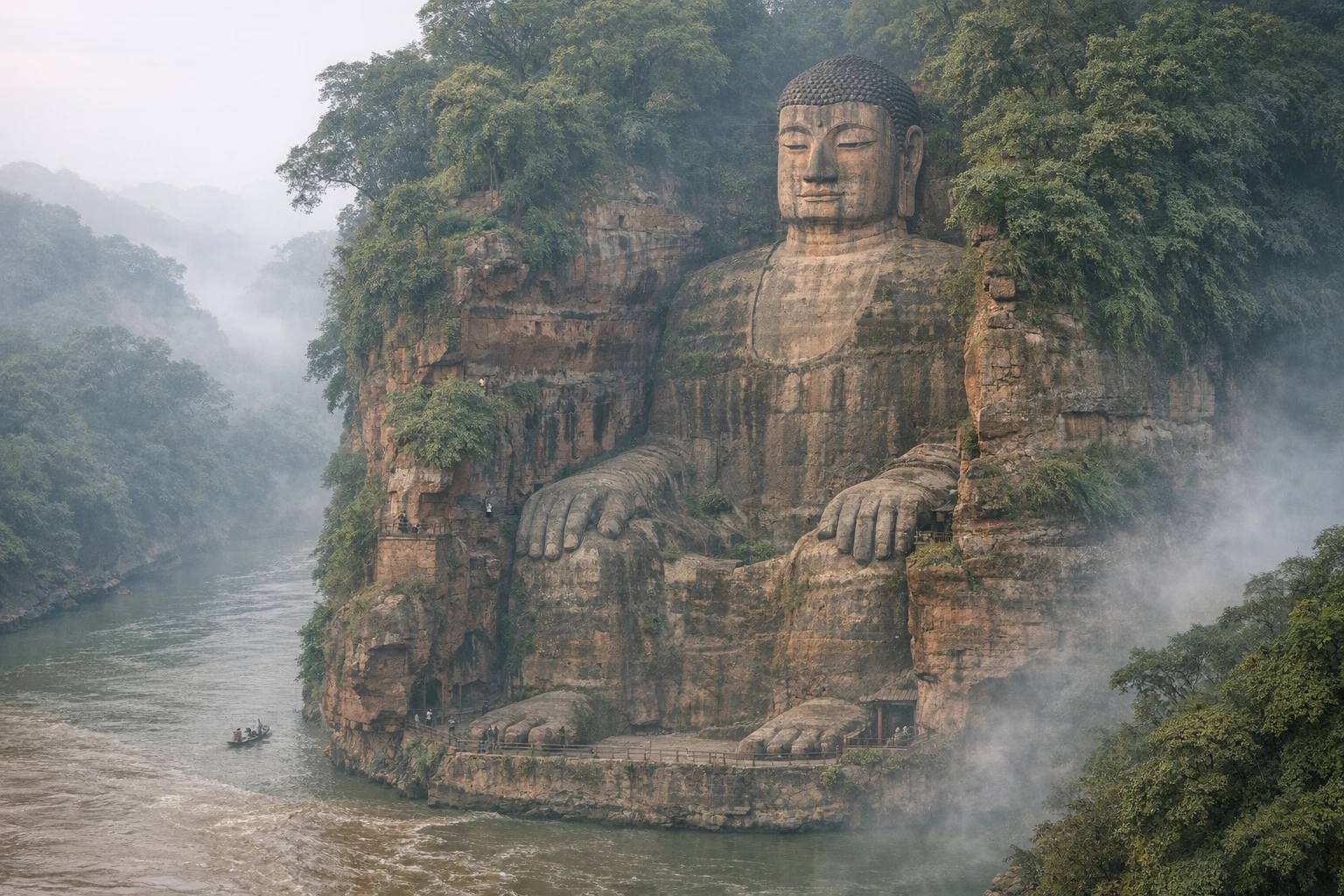
For a more extended itinerary, the Leshan Giant Buddha—a 71-meter Tang Dynasty rock carving at the confluence of three rivers, about 150 km south of Chengdu—makes an outstanding addition. A long weekend allows comfortable visits to Dujiangyan, Mount Qingcheng, and Leshan, with Chengdu as a comfortable central hub and the city’s famed hotpot restaurants as nightly reward.
Why Dujiangyan Still Matters
Most ancient engineering marvels survive as ruins—fragments that require imagination to reconstruct and historical records to understand. Dujiangyan is different. It works. Every spring, engineers inspect and clear the channels using methods broadly recognizable to Li Bing. Every summer, the Min River surges from the mountains, and the Fish Mouth Levee divides it with the same geometry it has used for 2,300 years. Every harvest, the Chengdu Plain produces food at a scale that sustains tens of millions of people, as it has done since the Qin Dynasty prepared its unification campaign.
This continuity carries lessons that modern hydraulic engineering has sometimes learned the expensive way. Large dam projects built in the twentieth century with supreme confidence in concrete and steel have silted up, triggered induced seismicity, destroyed river fisheries, and displaced millions of people. Dujiangyan, which works by redirecting rather than blocking the river, has done none of these things. Li Bing’s design treated the Min’s sediment load, seasonal energy, and natural flood variation not as problems to be eliminated but as properties to be redirected toward useful ends.
The system is not without ongoing demands—annual maintenance and periodic major dredging remain necessary, and the downstream network has been substantially expanded with modern infrastructure over centuries. But as a proof of concept for hydraulic engineering that works with natural processes rather than against them, Dujiangyan remains without equal. Engineers, environmental scientists, and policymakers from around the world visit not merely to admire an artifact of antiquity but to learn from a solution that has outlasted every political system, every military empire, and every competing technology built in its shadow.
Quick Facts
| Detail | Information |
|---|---|
| Location | Dujiangyan City, Sichuan Province, China |
| Built | c. 256 BCE |
| Builder | Li Bing and Li Erlang, Qin Dynasty |
| Type | Irrigation and flood-control hydraulic system |
| UNESCO Status | World Heritage Site since 2000 (with Mount Qingcheng) |
| Still Operational | Yes — irrigates 668,000+ hectares |
| Distance from Chengdu | ~60 km northwest |
| Travel Time from Chengdu | ~40 minutes by high-speed rail |
| Admission | Approx. ¥80 (subject to change) |
| Opening Hours | Daily, typically 8:00 AM – 6:00 PM |
| Best Time to Visit | Spring (March–May) or Autumn (September–October) |
| Key Structures | Fish Mouth Levee, Flying Sand Weir, Bottle-Neck Channel |
Explore More
Dujiangyan anchors a broader journey through Sichuan’s deep layering of natural beauty and human history. From the Taoist mist of Qingcheng Shan to the bronze mysteries of Sanxingdui, from the riverside grandeur of Leshan to the teahouse lanes of old Chengdu, the province rewards travelers who move slowly and look carefully. At Dujiangyan itself, leave time beyond the main hydraulic circuit for the Fulong Temple’s Han Dynasty stone portrait of Li Bing, the Anlan suspension bridge swaying above the inner river, and the Erwang Temple complex dedicated to the father and son whose reading of water changed the course of Chinese history.
What Li Bing built was not merely infrastructure. It was a demonstration that civilization can endure by understanding the systems it inhabits rather than simply overriding them. More than two thousand years on, that demonstration is still running—and still winning.
Frequently Asked Questions
What is the Dujiangyan Irrigation System?
Dujiangyan is a 2,300-year-old irrigation and flood-control system built around 256 BCE on the Min River in Sichuan Province, China. It is the world's oldest surviving no-dam irrigation project and remains fully operational, irrigating over 668,000 hectares of farmland today.
Who built Dujiangyan?
Dujiangyan was designed and constructed by Li Bing, governor of Shu under the Qin state, together with his son Li Erlang. Li Bing spent years observing the Min River's hydrology before devising his innovative diversion and flood-control solution around 256 BCE.
Is Dujiangyan a UNESCO World Heritage Site?
Yes. Dujiangyan was inscribed as a UNESCO World Heritage Site in 2000, jointly with the nearby Taoist sacred mountain of Mount Qingcheng (Qingcheng Shan), which rises just 16 km to the southwest.
How does the Dujiangyan system work?
Three interlocking components manage the Min River: the Fish Mouth Levee splits the river into inner and outer channels; the Flying Sand Weir regulates water levels and automatically flushes sediment through centrifugal force; and the Bottle-Neck Channel limits the volume entering the irrigation network, functioning as a natural flow regulator.
Is Dujiangyan still in use today?
Yes. After more than 2,300 years, Dujiangyan continues to irrigate over 668,000 hectares of farmland on the Chengdu Plain and supplies water to tens of millions of people in Sichuan Province, making it one of history's most enduring pieces of infrastructure.
How do I get to Dujiangyan from Chengdu?
Dujiangyan is approximately 60 km northwest of Chengdu. The fastest option is the high-speed intercity rail from Chengdu North Station (Chengdu Bei) to Dujiangyan Station, roughly a 40-minute journey. Buses from Chadianzi Bus Station also serve the route, taking around 1.5 hours.
Can I visit Dujiangyan and Mount Qingcheng on the same day?
Yes, and most visitors do. Dujiangyan requires 2 to 3 hours, and Mount Qingcheng is just 16 km away with a shuttle bus connection. An early start from Chengdu makes it comfortable to explore both sites in a single day.