Quick Info
Curated Experiences
Daily Hattusas Bogazkoy Tour
Private Hattusa and Yazilikaya Day Tour from Ankara
The wind at Hattusa carries open steppe air across broken walls, carved gates, and long stone lines that once enclosed one of the great capitals of the Bronze Age. In central Turkey, near modern Boğazkale, this was the political heart of the Hittite Empire—a power that rivaled Egypt, fought at Kadesh, and signed one of the world’s earliest known peace treaties. If you are searching for a Hattusa Turkey travel guide that goes beyond a quick checklist, this is the place to start: this is not a compact ruin you stroll in one hour, but a landscape-city that asks you to imagine roads, sanctuaries, archives, and armies spread over hills. What makes Hattusa remarkable is scale plus survival. You can stand at Lion Gate and still read the force of imperial symbolism in the stone; you can trace the Great Temple precinct and feel how administration and religion were woven together; and you can continue to nearby Yazılıkaya, where processions of deities still emerge from rock faces with startling clarity. Ancient Travels recommends treating Hattusa as a full narrative day, not a rushed stop. This guide covers the city’s history, the monuments that matter most, transport from Ankara and surrounding hubs, practical ticket and timing details, and a realistic itinerary for combining Hattusa with nearby sites. ## History: Capital of an Anatolian superpower
Before empire: Hattian roots and early settlement (c. 3rd millennium-18th century BCE)
Long before the Hittite kings, the region around Hattusa was occupied by communities archaeologists connect to Hattian cultural traditions. Its position mattered: upland routes linked central Anatolia to Black Sea zones and to southern corridors toward Syria and Mesopotamia. Early fortified occupation suggests people understood the defensive advantages of ridgelines and controlled approaches. By the early 2nd millennium BCE, the wider region was already integrated into Assyrian merchant networks centered on Anatolian trade colonies. Even before imperial monuments appeared, Hattusa sat inside a web of exchange, language contact, and political competition. ### Rise of the Hittite state (c. 17th-15th centuries BCE)
Hattusa entered recorded political history dramatically when Hattusili I established it as a royal seat, giving the city and dynasty lasting identity. Over generations, rulers expanded fortifications, palace zones, and cult spaces while consolidating authority over rival Anatolian centers. Written archives in cuneiform tablets reveal diplomatic marriages, military planning, legal rulings, and ritual obligations. This was not a loose tribal stronghold but a literate court society that depended on records and bureaucracy. The city’s growth in this period laid the framework for later imperial expansion and the architectural ambitions still visible across the site. ### Imperial zenith and international diplomacy (c. 14th-13th centuries BCE)
Under rulers such as Suppiluliuma I, Muwatalli II, and Hattusili III, Hattusa became the command center of an empire stretching across much of Anatolia and into northern Syria. The famous conflict with Egypt at Kadesh and the later peace agreement with Ramesses II place the Hittites firmly in the highest tier of Late Bronze Age powers. In this era, Hattusa’s upper city expanded with temples, gates, and massive defensive works. Religion and kingship were inseparable: state ceremonies, divine legitimacy, and foreign policy all intersected in the capital’s ritual calendar. The city projected power both militarily and symbolically. ### Collapse, transformation, and later memory (c. 12th-8th centuries BCE)
Like many eastern Mediterranean centers, Hattusa was drawn into the wider Late Bronze Age crisis around the early 12th century BCE. Imperial structures fragmented, populations shifted, and large administrative systems failed. The city was not simply erased overnight, but its role as imperial capital ended. Subsequent Iron Age groups, including Phrygian and later Galatian communities in the broader region, occupied and reused parts of the landscape in changing ways. By classical antiquity, the specific political memory of Hattusa had faded, even as local traces of older sacred and fortified spaces persisted in the terrain. ### Modern rediscovery and archaeology (19th century-present)
European travelers in the 19th century documented enigmatic reliefs and masonry at Boğazköy, but systematic archaeological work in the early 20th century transformed understanding of the site. Excavations by Hugo Winckler and collaborators uncovered thousands of cuneiform tablets, proving this was the long-sought Hittite capital named in ancient texts. Later Turkish and international teams mapped defensive lines, temple districts, and urban planning on an extraordinary scale. Hattusa’s inscription as a UNESCO World Heritage Site in 1986 recognized both monumental architecture and textual significance. Research continues today, refining chronology, ritual topography, and how imperial governance functioned in daily life. ## The Key Monuments: What to See at Hattusa
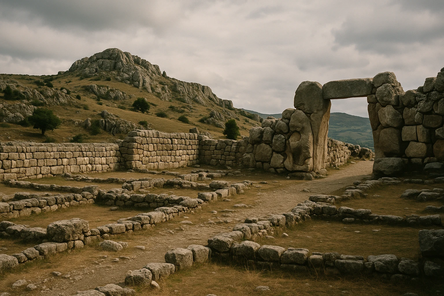
Lion Gate
The Lion Gate on the southwestern circuit is often the emotional beginning of a Hattusa visit. Built in the 14th-13th centuries BCE as part of the expanded upper-city fortifications, it combines practical defense with psychological theater. Two carved lions flank the passage, their bodies stylized but still muscular and alert, embodying royal protection and threshold power. The gate’s masonry shows careful block fitting and a controlled approach route that would have slowed entrants and exposed them to defenders. What survives today is enough to read both the engineering and message: crossing this line meant entering a king’s city under divine-royal guardianship. Photography tip: early morning side light brings out the sculpture volume and tool marks better than midday overhead sun. ### King’s Gate
On the southeastern side, the King’s Gate preserves one of Hattusa’s most discussed reliefs: a warrior figure, often interpreted as a deity rather than a mortal ruler, carved in high-profile posture near the passage. The iconography mixes martial and sacred language—helmet, weapon symbolism, and poised stance—suggesting that defense was framed as ritual order, not only military necessity. The gate belongs to the same broader fortification strategy as Lion Gate but carries a different visual program, likely tied to specific ceremonial routes or protective theology. Standing here, you can see how architecture directed movement while images directed interpretation. Photography tip: late afternoon helps the relief read more clearly, especially if you shoot at a slight angle instead of straight on. ### Sphinx Gate and Yerkapı earthworks
The Sphinx Gate crowns the monumental earth ramp known as Yerkapı, one of the most striking engineered features at Hattusa. This artificial embankment and tunnel system transformed topography into defense, raising walls and creating controlled passage points with commanding views over approaches. Original sphinx sculptures once marked the gate, reinforcing elite and possibly sacred associations at this elevated threshold. Even where original decorative elements are fragmentary or museum-held, the urban logic is clear: this was a designed statement of authority. Walking the slope and tunnel route gives you a physical sense of how movement, exposure, and surveillance were orchestrated. Photography tip: wide-angle shots from below capture the dramatic massing of the embankment against open sky. ### The Great Temple (Temple 1) and Lower City precinct
In the lower city, The Great Temple anchors Hattusa’s religious-administrative core. Built and remodeled across imperial centuries, the complex included a main cult building, large courtyards, magazines, and service spaces tied to offerings, storage, and official ritual logistics. Archaeologists identify this precinct with state worship of major deities associated with imperial legitimacy, likely including the Storm God and Sun Goddess traditions central to Hittite religion. The surviving foundations and room plans reveal a sophisticated institutional landscape: this was where faith, taxation in kind, and court ceremony overlapped. You are not looking at an isolated shrine but a working engine of empire. Photography tip: midday can flatten textures; if possible, visit the temple area when the sun is lower to emphasize wall lines and room geometry. ### City walls, towers, and the wider urban landscape
Hattusa’s fortification system is the site’s largest monument in aggregate, extending for kilometers with walls, gates, towers, and strategic high points integrated into rough terrain. Reconstructed stretches help visualize original height and defensive rhythm, but even unreconstructed sections communicate scale. The city was planned as a distributed urban organism with sacred, administrative, and military zones linked by roads and controlled entries. Driving between sectors is practical, yet brief walks at each stop are essential for understanding line-of-sight command and how landscape itself functioned as architecture. Photography tip: use elevated vantage points to capture walls as continuous lines; close shots alone can miss the city-scale concept. ### Yazılıkaya rock sanctuary
A short drive from the main ruins, Yazılıkaya is indispensable to understanding Hattusa. This open-air rock sanctuary contains carved processions of gods, goddesses, and royal figures in chambers formed by natural limestone outcrops. Most reliefs belong to the 13th century BCE and show a mature Hittite visual theology in which imperial kingship is embedded within cosmic order. The famous meeting scene of major deities, along with divine sequences and symbolic creatures, gives unusual access to state religion as image-program rather than text alone. Relief preservation varies with light, so patience pays off. Photography tip: arrive when sunlight enters obliquely; low-angle light dramatically improves legibility of worn figures. ## Getting There: Transportation and Access
Hattusa is reachable by road from Ankara and central Anatolian hubs, but the site is spread out enough that a car or organized tour is usually the most efficient way to visit. ### From Ankara
From Ankara, you are looking at roughly 230 km and about 3 to 3.5 hours each way depending on traffic leaving the capital and road conditions near Çorum. - Guided day tour: Most convenient for first-time visitors; transport and sequencing are handled. Typical full-day pricing is around 9,000-13,000 TRY ($280-410 USD) per person for small-group or private-style products. - Rental car: Best for flexibility and combining stops. Fuel and toll costs vary, but a day round-trip from Ankara often adds 1,800-2,800 TRY ($55-85 USD) on top of rental fees. - Intercity bus + local transfer: Budget option via Çorum or Sungurlu, then taxi/dolmuş to Boğazkale. Total transit can exceed 5 hours one way and schedules are limited. ### From Çorum and Boğazkale
If you overnight closer to the site, access is straightforward and far less rushed than a same-day Ankara return. - Taxi from Çorum: Usually 1 to 1.25 hours; about 1,600-2,400 TRY ($50-75 USD) each way depending on season and waiting time. - Local minibus/dolmuş: Service exists on some routes but frequency can be sparse; confirm return times before departing. - Self-drive from Boğazkale: Ideal for moving between lower city, upper city gates, and Yazılıkaya with minimal downtime. ### Admission and Hours
Expect separate entry controls for Hattusa sectors and Yazılıkaya, with common per-site prices often in the 8-15 EUR equivalent range each (paid in TRY, roughly 280-520 TRY / $9-16 USD depending on exchange and annual updates). Summer hours are typically longer, while winter closing times are earlier; check current Ministry of Culture postings before departure. Card payment may work at some points, but cash in Turkish lira is still wise as backup. For comfort and better photos, arrive early and start at upper-city gates before heat and group traffic build. ## When to Visit: Seasonal Considerations
Spring (March-May)
Spring is the strongest overall season for most travelers. Daytime temperatures commonly sit around 10-22°C (50-72°F), with green hills, clearer visibility, and manageable walking conditions across uneven ground. Crowds are moderate rather than heavy, and relief carving detail is often easier to read under softer light. A light jacket and layered clothing are enough for most days. If you want long walks plus good photography, this is the ideal window. ### Summer (June-August)
Summer brings dry heat and high sun, often around 25-34°C (77-93°F), with exposed areas feeling hotter on stone surfaces. Crowd levels vary, but tour traffic from Ankara is more common on weekends and holiday periods. Shade is limited in many sectors, especially around walls and elevated gates. Start at opening time, carry more water than you think you need, and plan a midday slowdown. Summer is workable, but timing discipline matters. ### Autumn (September-November)
Autumn rivals spring for comfort, typically around 12-24°C (54-75°F) early in the season and cooler later on. Light quality is excellent, winds are often gentler, and walking routes are pleasant for longer circuits between monuments. Visitor numbers usually feel balanced, with enough activity for services but fewer bottlenecks at key gates. For travelers who prefer mild weather and stable road conditions, early to mid-autumn is a very smart choice. ### Winter (December-February)
Winter is quiet, atmospheric, and occasionally stark. Temperatures often range from -2 to 8°C (28-46°F), with wind chill on exposed ridges and possible snow or icy patches affecting footing. Crowds are low, sometimes minimal, which can make the city feel hauntingly immense. Bring warm layers, gloves, and sturdy shoes with grip. If you value solitude and don’t mind cold conditions, winter offers a powerful, reflective experience. ## Combining Hattusa with Boğazkale and Yazılıkaya
The best way to combine Hattusa’s major zones is to think in movement arcs rather than checklist stops. Start by reaching the upper-city fortifications around 8:30 AM, when temperatures are cooler and directional light helps reliefs at Lion Gate and King’s Gate read more clearly. Spend the first 90 minutes moving between these gates and the Yerkapı/Sphinx Gate sector, pausing at high viewpoints to understand wall lines in relation to surrounding valleys. By 10:30 AM, drive down toward the lower city and walk the Great Temple precinct while your historical context is still fresh. Around 12:15 PM, break in Boğazkale for lunch—small local lokantas usually offer straightforward Anatolian dishes, and this pause makes the second half of the day much more enjoyable. Resume by 1:30 PM with a short transfer to Yazılıkaya, where 60 to 90 minutes is usually enough if you move slowly through the carved chambers and allow time for photography. If you are self-driving, you can finish with one last viewpoint stop near reconstructed wall sections around 3:30 PM before starting your return. In total, this combined circuit takes about 6 to 8 hours on the ground, excluding long-distance transport. Travelers based in Ankara should expect a full 12-hour day door-to-door; those staying in Çorum or Boğazkale can do the same route at a far better pace. ## Practical Information
What to bring
- Water and electrolytes: At least 1.5 liters per person in spring/autumn, 2+ liters in summer. - Sun and wind protection: Hat, sunscreen, and a light layer; exposed ridges can be intense in both heat and cold. - Footwear: Grippy walking shoes for uneven stones, dirt tracks, and sloped sections. - Cash in TRY: Useful for tickets, parking, or small local vendors if card systems are down. - Camera with zoom: Relief details at gates and Yazılıkaya are easier to capture with focal range. ### Etiquette and accessibility
Treat carved surfaces and masonry as fragile heritage—avoid climbing on walls or touching relief faces. Accessibility is mixed: some viewpoints are close to parking, but many paths are uneven and not fully adapted for wheelchairs. If mobility is limited, prioritize gate viewpoints plus selected lower-city stops and allow extra transition time. ## Why Hattusa Matters
Hattusa matters because it proves that the story of the ancient Near East is wider than the familiar Nile-and-Mesopotamia corridor. Here, in central Anatolia, a literate imperial system built its own diplomatic language, legal traditions, and sacred-political architecture powerful enough to negotiate as an equal with Egypt. The city is not preserved as polished spectacle; it survives as a vast, weathered framework that asks you to supply imagination, context, and patience. That is exactly why the experience stays with you. You cross a lion-guarded threshold, stand in temple courtyards where offerings and administration once overlapped, then step into Yazılıkaya where gods still process across stone. In a single day, you see how empire was enacted through roads, gates, archives, and ritual choreography. Hattusa reminds you that history is not a single civilizational line; it is a field of parallel centers, each shaping the world in ways later memory only partly preserved. Visit with time, and the silence of these hills begins to read like text. Quick Facts
| Attribute | Details |
|---|---|
| Location | Boğazkale, Çorum Province, Turkey |
| Ancient Name | Hattusa (Hattuşa) |
| UNESCO Status | World Heritage Site (1986) |
| Established | c. 2000 BCE fortified settlement |
| Distance from nearest hub | ~230 km from Ankara (about 3-3.5 hours by road) |
| Entry Fee | Typically 280-520 TRY ($9-16 USD), depending on sector and season |
| Hours | Generally opens in the morning; longer summer hours, shorter winter hours |
| Best Time | Spring and autumn, early morning start |
| Suggested Stay | 3-5 hours on site; full day with Yazılıkaya |
Explore More Turkey
- Troy: Walk layered settlements and legendary walls tied to the Homeric world. - Göbekli Tepe: See ritual architecture from the dawn of settled life. - Ephesus: Experience a grand Roman city with theaters, streets, and elite houses.
Frequently Asked Questions
How much time should I plan for Hattusa?
You need at least 3 to 4 hours on site for a meaningful visit, and closer to 5 hours if you include Yazılıkaya properly. The ruins are spread across upper and lower sectors, so driving between points saves time and energy. If you are coming from Ankara, treat it as a full-day trip.
Is Hattusa worth visiting from Ankara in one day?
Yes, if you start early. The one-way drive is usually around 3 to 3.5 hours, and the scale of the city walls, gates, and temple district rewards the effort. A guided day tour works well if you do not want to navigate rural roads and site sequencing yourself.
Do I need separate tickets for Hattusa and Yazılıkaya?
They are commonly sold as separate entries, though combined options may appear seasonally through the Turkish museum system. Bring enough cash in Turkish lira in case card terminals are offline. Verify current pricing at the gate or with the local museum office before arrival.
What are the main highlights at Hattusa?
Most travelers prioritize Lion Gate, King's Gate, the Sphinx Gate earthworks, the Great Temple district, and the city walls with reconstructed stretches. Yazılıkaya is equally important for its rock-cut reliefs of gods and royal ritual imagery. Together they explain both the political and sacred life of the Hittite capital.
When is the best season to visit Hattusa?
Spring and autumn are ideal for comfortable walking temperatures and clear light for relief photography. Summer can be very hot and exposed, especially in the upper city. Winter visits are atmospheric and quiet, but cold winds and occasional snow can slow movement between sectors.
Is Hattusa suitable for travelers with limited mobility?
Some key viewpoints are accessible by car with short walks, but many paths are uneven, stony, and sloped. Yazılıkaya includes rough ground that can be challenging without support. Travelers with mobility concerns should focus on the most accessible stops and allow extra time at each one.
Nearby Ancient Sites
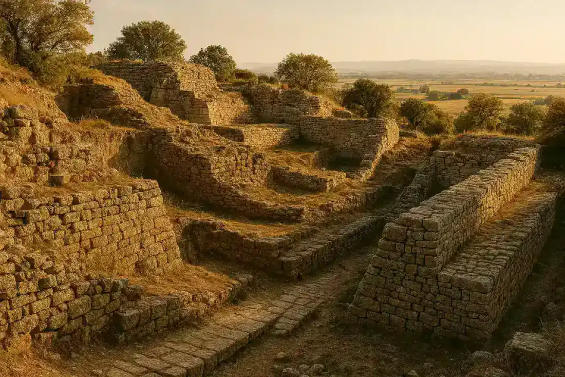
Troy Turkey Travel Guide 2026: Legendary City of Homer's Iliad
Multiple (Nine Layers)Walk the walls of ancient Troy, the legendary city of Helen and the Trojan Horse. Our guide covers n...
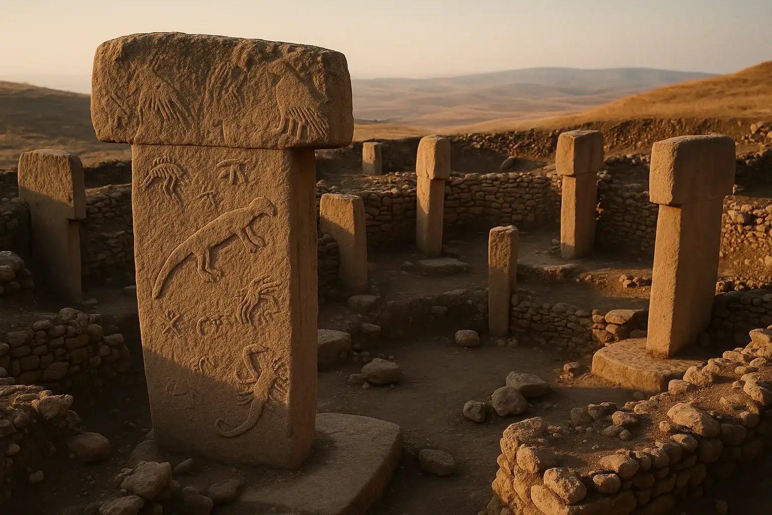
Göbekli Tepe, Turkey: The World's Oldest Temple Complex
Pre-Pottery NeolithicDiscover Göbekli Tepe, the 12,000-year-old archaeological wonder in Turkey that rewrites human histo...
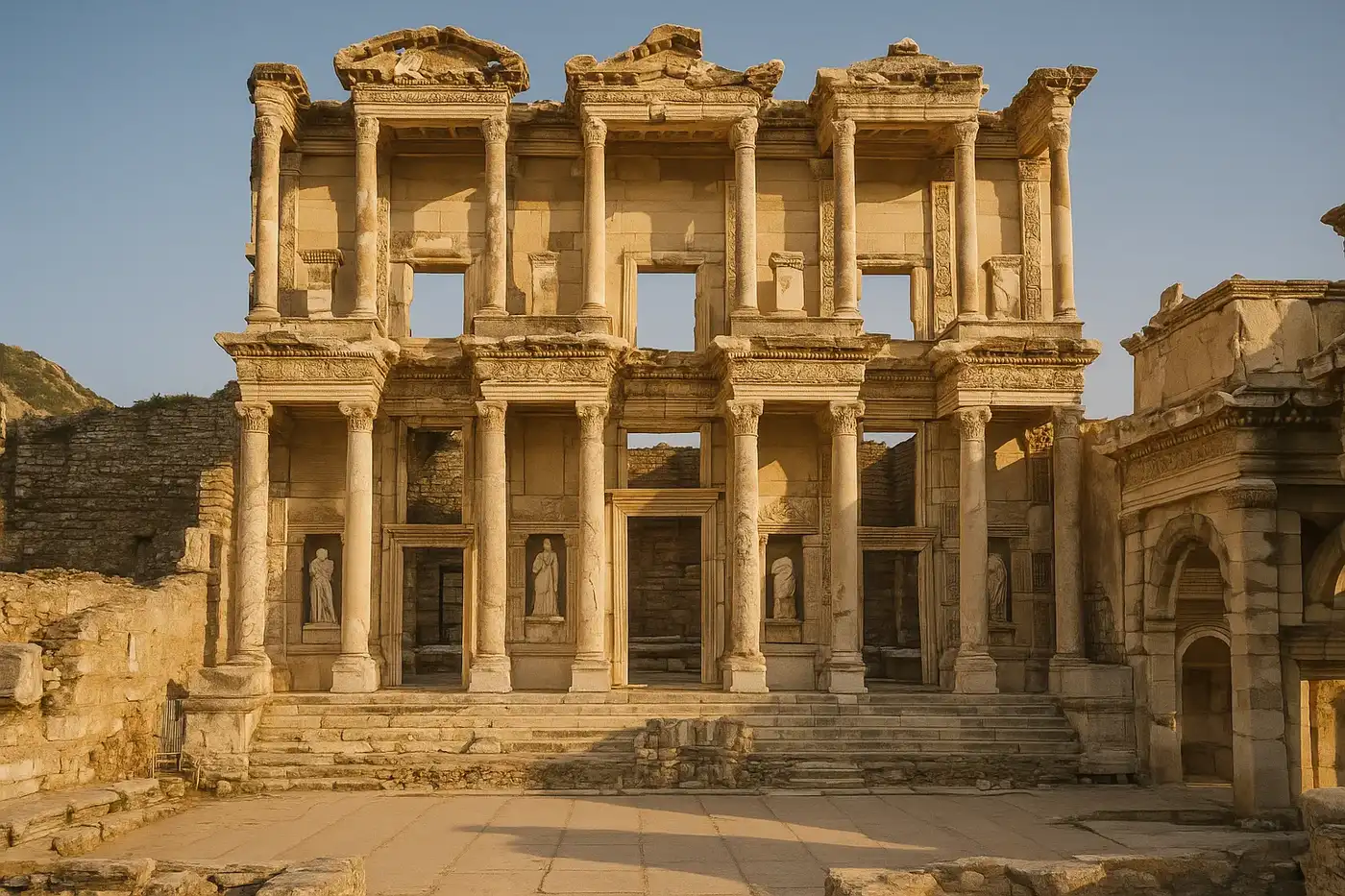
Ephesus Turkey Travel Guide: Library of Celsus & Terrace Houses
Greco-RomanDiscover Ephesus, the best-preserved ancient city in the Mediterranean. Our complete guide covers th...