Quick Info
Curated Experiences
Kaş Kekova Boat Trip by KaşTurları
Kekova Sunken City Boat Tour from Demre
Private Kekova and Simena Cruise from Kaş
In this Kekova Turkey travel guide, the first thing to understand is that Kekova is not one ruin and not one island. It is an entire archaeological seascape: a chain of harbors, coves, village ridges, and submerged walls spread across one of the most beautiful corners of Turkey’s Lycian coast. You do not walk through a single gate and enter “the site.” Instead, you move through it by boat, by short village paths, and by elevated viewpoints that make the relationship between sea and settlement suddenly clear. That is exactly what makes Kekova unforgettable.
Where many ancient destinations are defined by a single monument, Kekova in Turkey is defined by continuity. Lycian, Roman, Byzantine, medieval, and modern communities all used the same channels and anchorages, even as earthquakes and changing coastlines altered what stayed above water. The famous Sunken City zone is the visual anchor, but the experience is fuller when you include Kaleköy (ancient Simena), the castle ridge, and surrounding bays. At Ancient Travels, we recommend planning Kekova as a full-day journey from Demre or Kaş. This guide covers the historical timeline, key places to prioritize, transport logistics, ticketing realities, seasonal strategy, and how to combine Kekova with nearby Lycian highlights without rushing the day.
History: The Lycian Coast Where the Sea Kept the Record
Lycian maritime settlements (c. 5th century BCE-1st century BCE)
The earliest identity of Kekova belongs to Lycia, a regional culture built around independent city-states connected by sea routes and mountain valleys. Settlements such as Simena and Aperlai functioned as practical maritime nodes rather than imperial capitals. Their importance came from protected anchorages, local agricultural exchange, and coastwise trade that linked inland communities with wider Mediterranean traffic. Lycian funerary traditions, especially stone sarcophagi and rock-cut tomb forms, placed memory directly in the landscape people used every day. In Kekova, that relationship still feels immediate: harbor, home, and burial space were never far apart, and the coastline itself became the social map.
Roman administration and coastal prosperity (1st century BCE-4th century CE)
When Rome absorbed the region, Kekova’s settlements entered a broader imperial economy. Under Roman governance, maritime routes became more stable, and small ports along this coast benefited from predictable trade and taxation systems. Archaeological remains around the island and near village shorelines suggest sustained occupation through this period, including quay infrastructure, domestic walls, and workshop zones tied to everyday harbor life. Roman construction often reused earlier Lycian masonry, creating layered architectural signatures now visible both on land and below water. Kekova was not designed as monumental propaganda; it was a working coast, and that practical quality is part of why its remains still feel legible.
Byzantine adaptation and seismic change (4th-11th centuries CE)
As the eastern empire Christianized, the Kekova zone shifted into a Byzantine world with chapel remains, fortified high points, and changing trade priorities. Communities adapted to new religious and political realities while continuing to rely on the same maritime geography. Then a sequence of earthquakes and shoreline subsidence altered the settlement edge over centuries. Buildings near the waterline cracked, tilted, or gradually sank below sea level, producing what visitors now call the Sunken City. It was likely not one catastrophic overnight event, but cumulative geological change. The result is a rare archaeological condition: architecture preserved in place yet partially submerged, forcing modern visitors to interpret a city through water.
Medieval and Ottoman continuity (11th-19th centuries)
Through Seljuk, Crusader-era pressures, and Ottoman rule, the coast remained inhabited but peripheral to major inland power centers. Kaleköy/Simena stayed relevant because it offered defensible elevation and sheltered access to the sea. The castle ridge visible today reflects medieval and later fortification phases, while earlier strata beneath it remind us that each era rebuilt with inherited stone. Regional life shifted toward fishing, small-scale agriculture, and localized movement rather than large urban expansion. Historically, this period matters because it preserved habitation. Kekova did not become an abandoned relic; it stayed a lived landscape where ancient structures were reused, repurposed, and slowly integrated into village life.
Modern archaeology and protected waters (20th century-present)
In the 20th century, systematic surveys documented submerged and coastal remains and helped establish Kekova as one of Turkey’s most distinctive protected archaeological marine zones. Conservation policies now regulate anchoring, diving, and swimming over sensitive ruins, which is why most tours pass slowly through designated corridors rather than allowing direct immersion in the core area. This restriction is not a tourism inconvenience; it is the preservation strategy that keeps wall lines and shoreline structures visible for future generations. Today’s Kekova is therefore both historic and contemporary: a place where local communities still host travelers while legal protection preserves a fragile underwater archive.
The Key Monuments: What to See at Kekova
The Sunken City shoreline
The central experience is the slow pass along Kekova Island’s protected edge, where submerged wall foundations, stair traces, and building outlines appear beneath clear water. On calm mornings you can read entire room footprints and shoreline retaining lines from deck level, especially with polarized sunglasses. What you are seeing is not one isolated monument but part of an ancient urban fringe affected by tectonic movement and long-term subsidence. The visual impact comes from partial presence: enough survives to understand settlement patterns, but enough is missing to remind you how unstable coastlines can be. Keep your camera ready, but spend a few minutes simply looking with the naked eye; your depth perception improves once you stop chasing only postcard angles.
Simena Castle above Kaleköy
Rising over Kaleköy harbor, Simena Castle delivers the best land-based perspective on the entire Kekova system. The climb is short but steep and uneven, with loose stones and little shade, so good footwear and water are essential. The fortification visible today reflects medieval rebuilding phases, yet the site sits over older occupation layers tied to antiquity. One standout feature is a compact rock-cut theater often linked to Lycian foundations, unusually integrated into a defensive setting. From the upper ridge, you can trace boat channels, identify protected coves, and understand how settlements were distributed for visibility and shelter rather than monumental symmetry. Late afternoon usually offers the most forgiving light for both views and photos.
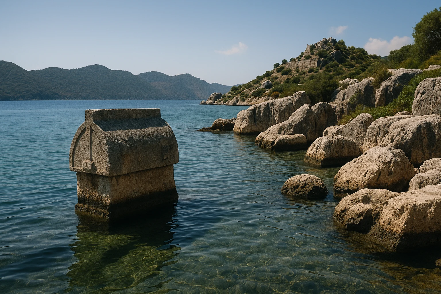
The Lycian sarcophagus at Kaleköy harbor
Near the harbor sits Kekova’s most recognizable image: a Lycian sarcophagus positioned so close to the waterline that it seems to rise directly from the sea. Its fame is not accidental. The monument captures the defining character of this coast, where funerary architecture, village life, and maritime movement coexist in one compressed frame. Lycian burial traditions often placed memory in visible civic contexts, and this example remains a powerful expression of that practice. Arrive early or linger later in the day if possible; midday tour clusters can briefly crowd the narrow waterfront viewpoints.
Tersane Bay remains
Tersane Bay is usually presented as a swim stop, but it also preserves important traces of Kekova’s working maritime past. Along the shoreline, scattered wall lines and structural remnants suggest workshop, storage, and harbor-support functions connected to anchorage life. Operators sometimes describe the area as a former shipyard; regardless of labels, the archaeological logic is practical coastal infrastructure. The bay helps you understand Kekova as an economic landscape, not only a scenic ruin zone. If your captain permits swimming outside restricted areas, look back at shore from the water. That reverse angle often makes structural alignments much easier to read.
Aperlai-facing route and the wider seascape
Longer cruises and private charters may include broader passes toward the Aperlai sector, another Lycian coastal settlement linked to Kekova through sea routes and defensive topography. Even from a distance, this leg clarifies that Kekova formed part of a network, not an isolated destination. Small ports, ridge settlements, and protected inlets created a distributed system resilient to political change and seasonal weather. For travelers, this wider route is often the moment Kekova shifts from “beautiful boat trip” to historical landscape study. If conditions are windy, ask your captain where the clearest lee-side viewing usually happens; micro-conditions can dramatically affect what you see below the surface.
Getting There: Transportation and Access
Kekova visits work best when planned as a two-stage route: road transfer to a harbor, then boat access to the archaeological coastline.
From Demre
Demre is the most efficient base for travelers focused on maximizing time on the water. The transfer to Üçağız harbor is short, and in-season departures are frequent.
- Taxi: 700-1,100 TRY ($22-34 USD), usually 20-30 minutes from central Demre.
- Dolmuş (local minibus): 60-100 TRY ($2-3 USD), cheaper but less frequent and slower.
- Rental car: 1,200-2,200 TRY/day ($37-68 USD) plus fuel; useful if combining Myra and Kekova.
From Kaş
Kaş has more hotels and nightlife, but the road leg is longer. It is still a strong base if you value atmosphere and do not mind an earlier start.
- Taxi/private transfer: 2,200-3,300 TRY ($68-102 USD), around 60-75 minutes to Üçağız.
- Dolmuş + local connection: 140-260 TRY total ($4-8 USD), typically with at least one change.
- Rental car: 1,200-2,400 TRY/day ($37-74 USD); parking near harbor areas can fill by mid-morning.
From Antalya Airport
Direct same-day airport-to-boat planning is possible but long. Most travelers enjoy the day more by overnighting first in Kaş or Demre.
- Private transfer: 6,500-9,500 TRY ($200-293 USD), roughly 3.5-4.5 hours depending on traffic.
- Intercity bus + local transfer: 450-900 TRY ($14-28 USD) plus final taxi/minibus link.
- Rental car: 1,500-2,900 TRY/day ($46-89 USD), practical for multi-stop Lycian itineraries.
Practical Information
Admission and Hours
Kekova does not function like a single fenced archaeological park with one gate fee. Your core cost is the boat experience, priced by operator type, route length, and season. Simena Castle usually has a separate entry fee paid onsite in TRY. In high season, most departures cluster between 9:30 AM and 11:00 AM and return in late afternoon. Shoulder-season schedules can be thinner, so booking one day ahead is wise. Card acceptance has improved, but small harbor points and village kiosks may still prefer cash. For visibility over the Sunken City walls, morning light is generally best; for castle views and harbor atmosphere, late afternoon is often stronger.
What to bring
- Sun protection: Hat, high-SPF sunscreen, and light long sleeves for reflected deck heat.
- Water: At least 1-1.5 liters per person, more in summer.
- Footwear: Grippy sandals or shoes for slippery docks and uneven castle paths.
- Cash in TRY: Useful for castle tickets, snacks, and small harbor purchases.
- Dry bag: Helps protect phones, documents, and camera gear during boarding and swim stops.
Accessibility and comfort
Kekova is enjoyable for many travelers without long hikes, but practical access varies by boat and dock design. Boarding can require stepping across narrow gangways, and sea conditions may affect stability. Ask operators in advance about ladder type, deck shade, and stop durations if someone in your group has mobility limitations or heat sensitivity. Kaleköy itself can be enjoyed at harbor level without climbing the castle, so mixed-ability groups can still share the day comfortably.
When to Visit: Seasonal Considerations
Spring (March-May)
Spring is usually the ideal season for Kekova, with temperatures often around 18-27°C (64-81°F). Morning seas are frequently calm, underwater visibility is strong, and hiking conditions in Kaleköy remain comfortable. Crowds rise during holiday weekends but are manageable on ordinary weekdays.
Summer (June-August)
Summer offers the widest selection of departures but also the toughest conditions, often 30-36°C (86-97°F) with intense sun reflection from deck and water. Crowds peak in July and August, especially around midday stops. Prioritize shaded boats, early departures, and hydration.
Autumn (September-November)
Autumn is excellent for balancing warm water with lighter crowds. Early season often sits around 22-31°C (72-88°F), cooling to roughly 16-24°C (61-75°F) by late November. Sea temperatures stay pleasant for swimming into October, and atmosphere in village stops is less rushed than midsummer.
Winter (December-February)
Winter is quieter and moodier, with many days around 10-18°C (50-64°F). You gain space and soft light, but wind and rain can cancel departures. Winter visits work best for flexible travelers who prioritize calm pacing over guaranteed full-service schedules.
Combining Kekova with Kaş and Demre
Kekova is most rewarding when treated as the center of a full coastal day. A strong rhythm starts with road transfer to Üçağız by 9:00 AM and boat departure around 9:30 AM, giving you the best chance of low-glare passes over the Sunken City corridor. After late-morning cruising, most routes stop in a cove for a swim outside protected archaeological waters. By 1:00 PM, many itineraries reach Kaleköy, where you can choose between a harbor lunch, short waterfront exploration, or the castle climb if temperatures are manageable.
Cruising back in mid-to-late afternoon often brings softer shoreline light and a calmer pace once peak tour overlap passes. Travelers based in Demre can still continue to Myra for an early-evening look at the theater and Lycian tomb façade if energy and daylight allow. Kaş-based visitors usually return in time for sunset along the marina and dinner in the old town.
If you only have half a day, choose one focus: either a shorter boat route centered on submerged ruins or a land-focused Kaleköy visit with minimal cruising. Trying to force full cruise, castle climb, and additional inland archaeology into a tight half-day usually produces rushed transfers and weaker viewing conditions. Kekova rewards patience and sequence far more than speed.
Why Kekova Matters
Kekova matters because it changes how you read ancient places. Instead of a single monumental ruin, you encounter a coastline where history is dispersed across water depth, harbor edges, and lived villages. The past is visible, but not fully graspable at once. You piece it together from moving viewpoints: a submerged stair line, a sarcophagus at the shoreline, a castle ridge above present-day boats.
That layered experience mirrors the real history of the eastern Mediterranean better than many grander sites do. Civilizations did not replace each other cleanly; they adapted, reused, and carried inherited geography forward. In Kekova, Lycian, Roman, Byzantine, and later communities are not museum labels in separate rooms. They are simultaneous traces in one seascape still used by local people today. If your journey through Turkey is about depth rather than checklist tourism, Kekova offers one of the clearest lessons on the coast.
Quick Facts
| Attribute | Details |
|---|---|
| Location | Kekova region, Antalya Province, Turkey |
| Ancient Name | Simena (Kaleköy) within the wider Lycian coastal network |
| UNESCO Status | Not inscribed; protected archaeological and environmental marine zone |
| Established | c. 4th century BCE maritime settlement |
| Distance from nearest hub | ~20 km from Demre to Üçağız (20-30 min by road) |
| Entry Fee | Boat tour prices vary; Simena Castle usually charged separately |
| Hours | Most departures 9:30 AM-11:00 AM, return late afternoon |
| Best Time | Spring and early autumn, with morning ruin-viewing light |
| Suggested Stay | Full day (6-8 hours) |
| Top Highlights | Sunken City shoreline, Simena Castle, Lycian sarcophagus, Tersane Bay |
Explore More Turkey
- Myra: See Lycian cliff tombs and one of the best-preserved Roman theaters in the region.
- Patara: Explore a vast Lycian-Roman site spread across dunes and wetlands.
- Aspendos: Visit a remarkably preserved Roman theater and monumental aqueduct system.
Plan your broader route with our Turkey Ancient Sites Guide. For regional planning, read our Lycian Coast itinerary guide.
Frequently Asked Questions
How much time should I plan for Kekova?
Plan a full day if you want the complete experience. Most travelers spend 6-8 hours between the boat route, a Kaleköy stop, and optional castle climb. A half-day works only if you focus on either the cruise segment or village visit, not both in depth.
Can you swim in the Sunken City area?
Swimming is prohibited directly over the protected Sunken City ruins. Boats pass slowly through designated viewing corridors, then stop in nearby coves where swimming is allowed. This rule is strictly tied to conservation and is part of what keeps the remains visible today.
Do I need separate tickets for Simena Castle?
Usually yes. Boat prices and Simena Castle admission are often separate, and castle entry is normally paid on site in Turkish lira. Carry small cash denominations because village kiosks may not always take cards.
What is the easiest base for visiting Kekova, Kaş or Demre?
Demre is closer to Üçağız harbor and usually means shorter transfer times. Kaş has more hotels and dining options but a longer road leg to departure points. Both bases work well; choose Demre for efficiency and Kaş for atmosphere.
Is Kekova good for families and non-swimmers?
Yes. You can enjoy the core archaeological views entirely from the deck, and many boats are family-friendly. If anyone has mobility concerns, ask operators in advance about boarding steps, shade coverage, and how long the Kaleköy stop lasts.
What are the key highlights besides the Sunken City walls?
Top highlights include Simena Castle's panoramic ridge, the Lycian sarcophagus by Kaleköy harbor, and clear-water coves around Tersane Bay. Together they show Kekova as a complete cultural landscape, not just one underwater photo stop.
Nearby Ancient Sites
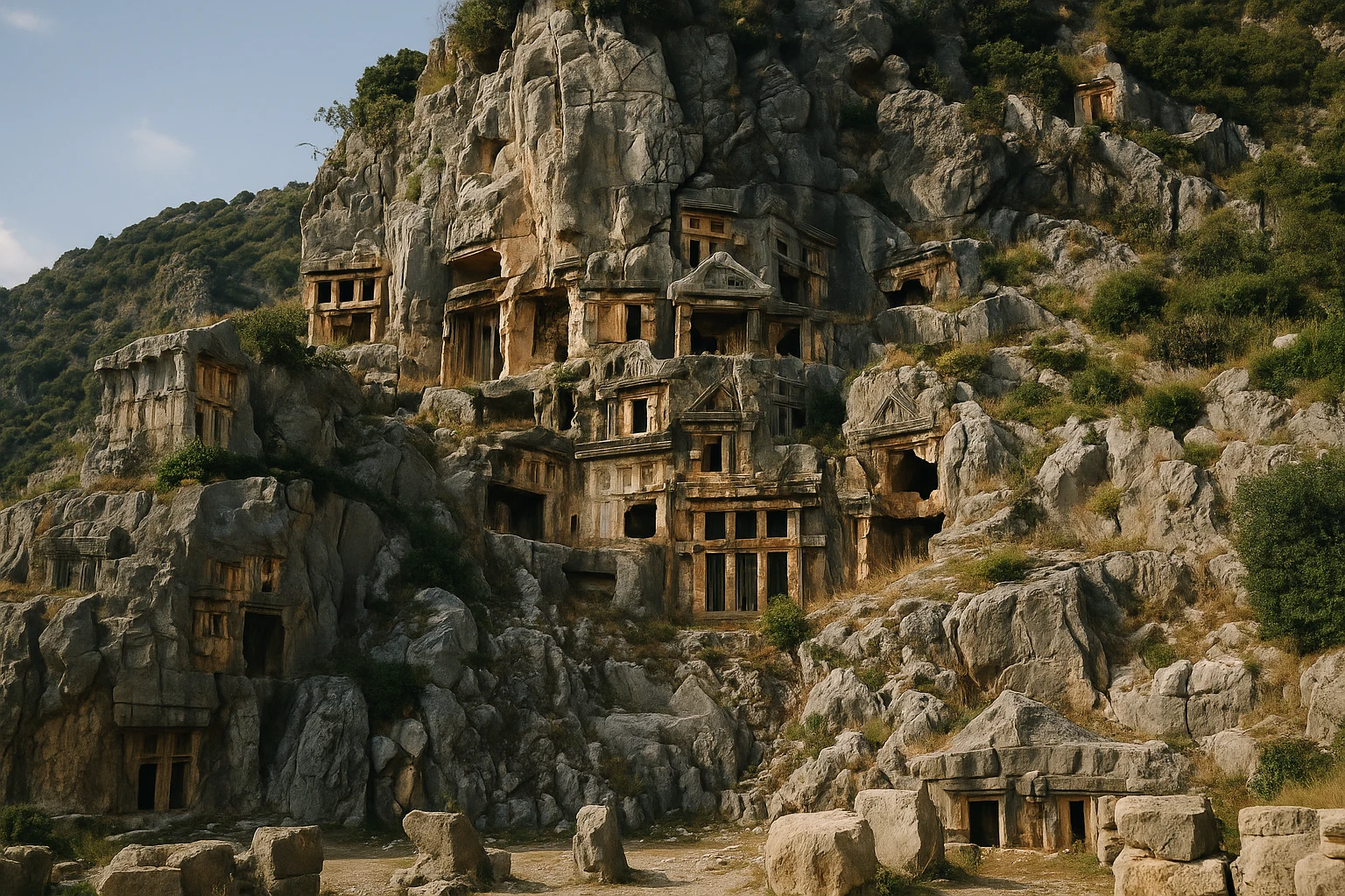
Myra Turkey Guide 2026: Lycian Tombs & Roman Theatre
Lycian-Roman-ByzantinePlan your Myra, Turkey visit with rock-cut Lycian tombs, a Roman theatre, tickets, hours, and transp...
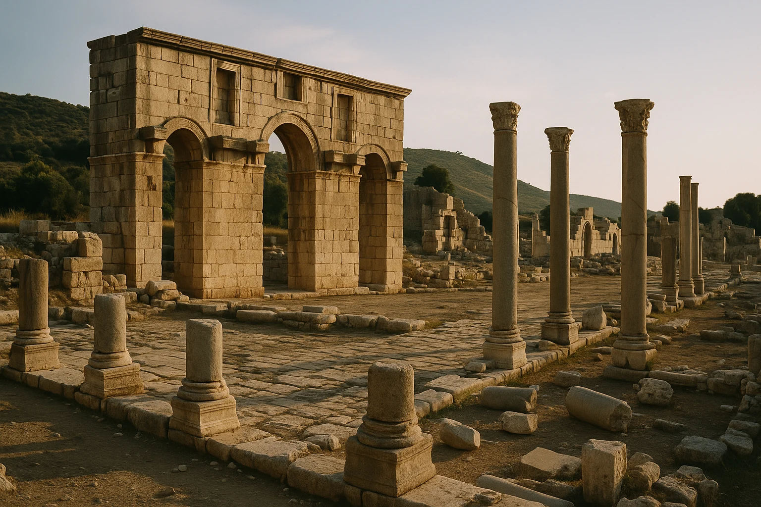
Patara Turkey Guide 2026: Lycian Capital & Roman Granary
Lycian-Hellenistic-Roman-ByzantinePlan your Patara, Turkey visit: explore Lycian and Roman ruins, climb the theater, and pair the site...
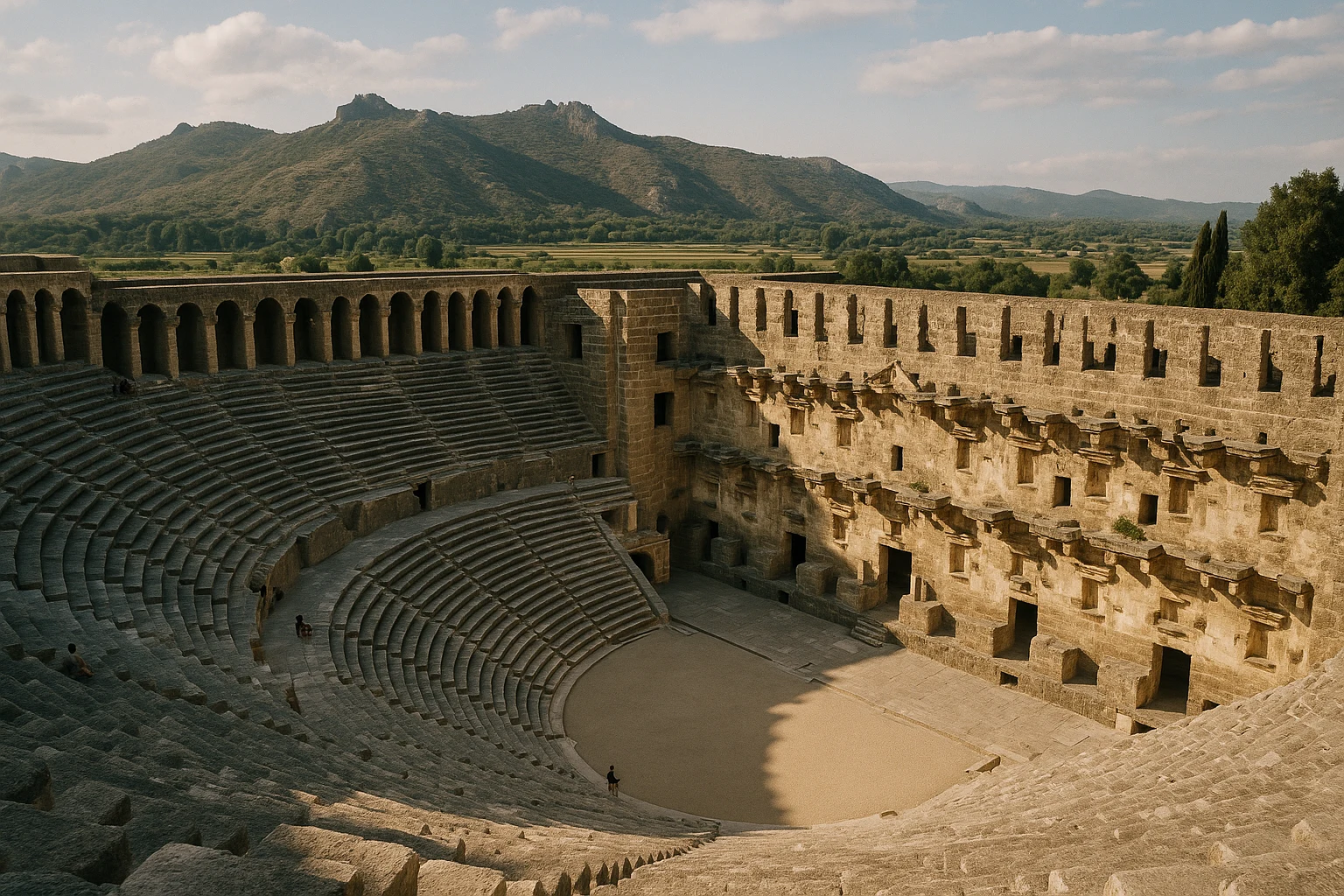
Aspendos Turkey Guide 2026: Roman Theatre & Pamphylian Aqueduct
Pamphylian-Greek-Roman-Byzantine-SeljukPlan your Aspendos visit in Turkey with practical tips on tickets, transport from Antalya, and what ...