Quick Info
Curated Experiences
Kuelap Full-Day Tour from Chachapoyas
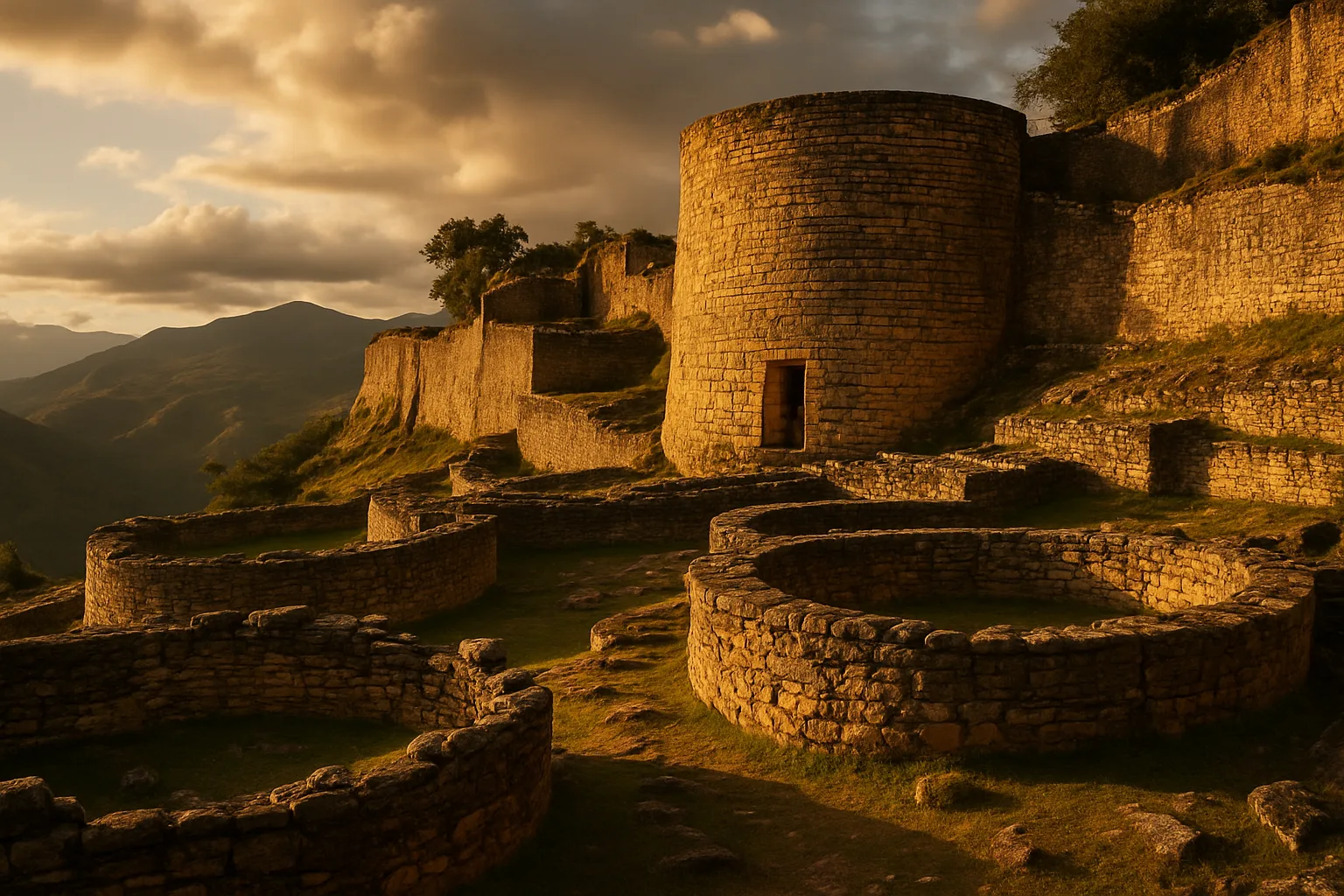
Somewhere above the cloud line of northern Peru’s Amazonas region, where the eastern Andes dissolve into ridges of humid forest rolling toward the Amazon basin, a stone wall rises from the jungle canopy with a presence that makes no immediate sense. It is too tall, too long, too massively constructed for the remote mountain ridge it occupies — nearly twenty meters high in places, built of fitted limestone blocks laid without mortar, enclosing a platform the length of six football fields. This is Kuelap, the great citadel of the Chachapoyas people, one of the most imposing pre-Columbian structures in the Americas and still among the least visited of Peru’s major ancient sites.
The fortress sits at 3,000 meters elevation on a limestone ridge above the Utcubamba River valley, roughly 65 kilometers southwest of the regional capital Chachapoyas. Construction began around 900 CE and continued across five centuries, during which the Chachapoyas — sometimes called the Cloud Warriors by archaeologists struck by their defiant resistance to later Inca conquest — built and rebuilt a walled city that enclosed more than 400 circular stone dwellings, ceremonial platforms, and storage facilities. A teleférico cable car installed in 2017 now carries visitors from Nuevo Tingo in the valley below to a station near the entrance in twenty minutes, transforming what was once a grueling half-day ascent into an accessible experience. This guide covers Kuelap’s layered history, its major structures, how to reach it from Chachapoyas and further afield, and how to combine it with the broader Amazonas archaeological circuit.
History: Citadel of the Cloud Warriors
Chachapoyas Origins (c. 400–900 CE)
The Chachapoyas were a distinct cultural group who occupied the cloud forest zone between the highlands of the Andes and the lowland Amazon — a territory of dramatic ridges, dense montane forest, and persistent mist. By around 400 CE, Chachapoyas communities had developed a recognizable architectural and artistic tradition centered on circular stone buildings decorated with geometric friezes, cliff-side burial sites containing mummified ancestors, and hilltop settlements positioned for visibility and defense. Unlike the coastal Moche, Chimu, or the later highland Inca, the Chachapoyas never unified into a centralized state. Instead, dozens of semi-autonomous communities occupied high ridgelines across a territory roughly the size of Switzerland, connected by trade, shared cultural conventions, and periodic conflict.
Construction and Expansion (c. 900–1470 CE)
Construction at Kuelap began around 900 CE and reflected a deliberate choice of military and ceremonial geography. The ridge offered commanding views across the Utcubamba valley and natural defensive advantages on three sides, and the builders amplified these with the immense outer wall that is today the site’s defining feature. That wall — up to 19 meters high in its best-preserved sections, 600 meters long on the main axis, and built from carefully fitted limestone — required a sustained construction program spanning generations. The interior platform it encloses is divided into a lower and upper level, with the upper platform accessible only through three narrow funnel-shaped entrances designed to force approaching visitors or attackers into single file. Circular houses of varying sizes filled the platform, each decorated with external friezes in diamond, rhombus, and zigzag patterns that are the hallmark of Chachapoyas visual culture. At its population peak, the compound may have housed several thousand residents, functioning as both a fortified city and a regional ceremonial center.
Inca Conquest and Resistance (c. 1470–1532 CE)
The Inca Empire under Túpac Inca Yupanqui incorporated the Chachapoyas territory around 1470 CE after a military campaign that Spanish chroniclers later described as unusually difficult. The Chachapoyas resisted longer than most Andean peoples, leveraging their hilltop fortresses and knowledge of the cloud forest terrain. Once conquered, they were subjected to the Inca system of mit’a labor and mitmaq population transfers, with many Chachapoyas warriors resettled to distant regions of the empire as colonial labor. At Kuelap, the Inca added rectangular structures inside the compound in their characteristic fitted masonry — a visible architectural counterpoint to the Chachapoyas circular tradition — but did not demolish or significantly alter the fortress itself. The site remained occupied through the early Spanish colonial period before gradual abandonment as population collapse from European diseases emptied the region.
Modern Rediscovery (1843–Present)
Juan Crisóstomo Nieto, a local Peruvian judge, documented Kuelap in 1843 as the first outsider to record the site systematically. Serious archaeological investigation followed in the 20th century, with Peruvian and international teams mapping the compound and excavating select structures. The full extent of the site — which includes satellite structures, roads, and agricultural terraces beyond the main citadel — remains incompletely documented. The 2017 inauguration of the teleférico, funded jointly by the Peruvian government and a French cable car company, transformed visitor access and marked a significant investment in the site’s tourism infrastructure. Visitor numbers grew substantially before the COVID-19 pandemic disrupted operations; the site has since reopened and the cable car system has been expanded with additional cabins.
The Key Monuments: What to See at Kuelap
The Outer Wall
The outer wall of Kuelap is the most immediate and arresting feature of the site. Its limestone blocks, many weighing hundreds of kilograms, are dry-laid in horizontal courses that rise to nearly 19 meters at the highest surviving section. Walking along the base of the wall and looking up at the coursed stone disappearing into the vegetation overhead gives a visceral sense of the construction effort invested over centuries. The wall is not entirely uniform — different building phases are visible in variations of block size and coursework angle — but the overall effect is of a continuous rampart enclosing the entire platform. The three original entrances cut through the wall are Kuelap’s most photographed features: narrow funnel passages only wide enough for one person to pass at a time, with the outer opening several meters wide and the inner opening barely a meter across, creating a natural chokepoint for crowd control or defense.
El Pueblo (The Settlement)
The majority of the Kuelap platform is occupied by El Pueblo, the residential and functional core of the settlement. Approximately 400 circular structures have been identified across the upper and lower platforms, ranging from small one-room dwellings to larger multi-function buildings. Many retain their lower wall courses and geometric exterior friezes, and several have been partially consolidated by archaeological conservation teams to stabilize collapsing sections. Walking through El Pueblo resembles navigating a dense stone neighborhood where paths thread between curved walls and the occasional tree growing through a collapsed room. The friezes are particularly striking on the better-preserved structures — rows of diamond patterns, interlocking rhombuses, and zigzag bands that distinguish Chachapoyas architecture from anything produced elsewhere in the Andes.
El Tintero (The Inkwell)
El Tintero, named by locals for its inverted conical shape, is the most architecturally distinctive individual structure at Kuelap. Unlike the other circular buildings on the platform, El Tintero narrows toward the base rather than sitting on the ground with a standard foundation — a construction technique that has no direct parallel at other Chachapoyas sites. Its function remains debated: proposed interpretations include a granary, a ritual burial structure, or a specialized storage facility. Whatever its original purpose, the inverted cone surrounded by rough ground vegetation makes it the most immediately recognizable structure for visitors and the one most frequently reproduced in photographs of the site. It stands in the southern section of the lower platform and is typically reached via a path that winds through a dense stand of native cloud forest trees.
El Castillo
At the highest point of the upper platform, El Castillo is a massive three-story circular tower approximately 8 meters in diameter and standing to a surviving height of around 6 meters. Its walls are significantly thicker than those of the residential structures below, and its interior appears to have been solid rather than habitable — suggesting a ceremonial or observational function rather than domestic occupation. The Castillo occupies the same position that a temple or primary shrine might in a coastal Andean site, though the Chachapoyas left no written records and archaeological excavation of the interior has not definitively established its ritual role. From the base of the Castillo on a clear day, the view south across the Utcubamba valley and toward the distant Andean peaks is exceptional, and on the best mornings the cloud forest below rolls in a continuous green canopy interrupted only by the silver thread of the river far below.
Getting There: Transportation and Access
Kuelap lies in one of Peru’s more remote regions, and reaching it from the main Peruvian tourist circuit requires a flight or long bus ride north from Lima or east from Chiclayo on the coast.
The Teleférico from Nuevo Tingo
The cable car station at Nuevo Tingo sits approximately 65 kilometers southwest of Chachapoyas on the road into the Utcubamba valley. The teleférico runs three-person gondolas on a 20-minute ascent to the upper station, from which the fortress entrance is a short walk. Operating hours are typically 8:00 AM to 4:00 PM (last ascent), and the cable car may be suspended during heavy rain or strong wind. Book the cable car in person at Nuevo Tingo or through your tour operator — no advance online booking system is reliably available. The round-trip cost is approximately 20 PEN ($5 USD) per person. The alternative is a narrow unpaved vehicle road ascending to a parking area near the entrance, usable in dry season in a high-clearance 4WD.
From Chachapoyas
The town of Chachapoyas (population ~20,000) is the base for visiting Kuelap. It lies 65 km northeast of Nuevo Tingo on a road that takes approximately 1.5 to 2 hours depending on conditions. Options include:
- Organized day tour: 65–100 USD per person, includes transport, cable car, and guide; the easiest option for independent travelers
- Colectivo and taxi: Colectivos from Chachapoyas to Pedro Ruiz and onward connections can reach Nuevo Tingo for 15–25 PEN ($4–7 USD) with patience; a return taxi from the valley to Chachapoyas adds 80–120 PEN ($21–32 USD)
- Rental car: Available in Chachapoyas; the road is paved for most of the distance and manageable in a standard vehicle during dry season
From Lima, Chiclayo, and Trujillo
No direct transport connects Lima to Chachapoyas conveniently. The standard routing is:
- Fly Lima to Chachapoyas (Movil Air or LC Perú, approximately 1.5 hours): the fastest option, flights limited to 2–3 days per week
- Lima to Chiclayo by air (1 hour), then bus to Chachapoyas via the Balta highway (7–9 hours by overnight bus, 80–120 PEN / $21–32 USD)
- Trujillo to Chachapoyas by overnight bus (6–8 hours); a useful option if combining with a northern coast itinerary that includes Chan Chan or Sipán
Admission and Hours
The site is open daily from 8:00 AM to 5:00 PM. Entry to the archaeological zone costs approximately 20 PEN ($5 USD) per person, paid in cash at the entrance. A licensed guide can be hired at the entrance for 40–60 PEN ($11–16 USD) and is recommended for understanding the site’s structural history; signage inside the compound is limited. There is a small visitor center with basic exhibits near the cable car upper station.
When to Visit: Seasonal Considerations
Dry Season (May–September)
This is the optimal window for visiting Kuelap. Skies clear reliably between late morning and early afternoon, the access road is in good condition, and the teleférico operates on a full daily schedule. Temperatures at 3,000 meters range from 12–20°C (54–68°F) during the day with cold nights. Mornings are best: arrive at Nuevo Tingo by 8:00 AM, take the first cable car, and explore the fortress in the clearest light of the day before afternoon cloud builds. July and August see the highest visitor numbers but the site is never genuinely crowded by major-site standards.
Wet Season (November–March)
Persistent cloud and afternoon rain are the norm from November through March. The fortress is often wrapped in mist, which creates a dramatically atmospheric visual but limits long-distance views and can make the stone paths slippery. Heavy rain can close the teleférico and render the unpaved access road impassable. If you visit in the wet season, book flexible transport and depart early enough to be on the site by 9:00 AM before conditions deteriorate. The cloud forest vegetation is at its most lush and the orchids that grow in the fortress walls are at peak bloom.
Shoulder Months (April and October)
April and October offer a reasonable compromise — better conditions than the wet season core, lighter crowds than peak dry season, and the landscape still carrying some green from the rains. October in particular can deliver several consecutive clear days in a row, making it one of the more underrated months to visit.
Combining Kuelap with the Amazonas Circuit
Kuelap is the anchor of one of Peru’s richest and most undervisited archaeological circuits, and most travelers who come this far dedicate at least three days to the Amazonas region.
From Chachapoyas, the Kuelap day trip is the obvious first priority. Return by late afternoon and spend the evening at a Chachapoyas restaurant sampling regional dishes — juane (rice wrapped in bijao leaves), cecina (dried smoked pork), and fresh highland trout are staples.
Day two can be dedicated to the Karajia Sarcophagi — a row of elongated anthropomorphic clay figures perched on an inaccessible limestone cliff face, each containing the mummified remains of a Chachapoyas leader. The figures stand 2.5 meters tall and face outward over the valley, their expressions stern and their positioning seemingly defying gravity. The site is reached by a 45-minute hike from the village of Cruz Pata, about 40 km from Chachapoyas.
Gocta Falls, once obscured from international attention until its measurement was published in 2006 revealing it to be among the world’s tallest waterfalls at 771 meters, lies approximately 1.5 hours from Chachapoyas. The hike to the base of the lower cascade takes two to three hours through cloud forest; the view of the upper fall from the valley requires only a shorter walk to a viewpoint. Together, Kuelap, Karajia, and Gocta form a three-day Amazonas itinerary that rewards the considerable effort required to reach this corner of northern Peru.
Why Kuelap Matters
Kuelap endures as an argument for the diversity of Andean civilization against the Inca-centric narrative that tends to dominate popular accounts of pre-Columbian Peru. The Chachapoyas were not a minor local culture absorbed passively into a greater empire — they were sophisticated builders who raised one of the most massive stone enclosures in the Americas before the Inca existed as a political entity, who resisted Inca military pressure for decades, and who left behind a visual and architectural tradition unlike anything produced elsewhere on the continent.
Standing inside the funnel entrance and looking up at the limestone wall rising to the treeline, it is impossible not to think about the sustained human effort embedded in those courses of fitted stone — the generations of builders who cut, transported, and laid blocks across five centuries with no written specification and no architectural tradition to draw on beyond their own accumulated knowledge. The Cloud Warriors built Kuelap in the clouds because that is where they lived and where their dead could look out across the forest canopy forever. It is a place that earns its remoteness.
Quick Facts
| Attribute | Details |
|---|---|
| Location | Luya Province, Amazonas Region, Peru |
| Civilization | Chachapoyas (Cloud Warriors) |
| UNESCO Status | Not listed (tentative list) |
| Established | c. 900 CE |
| Historical Period | c. 900–1532 CE |
| Distance from Chachapoyas | ~65 km; 1.5–2 hours by road |
| Entry Fee | ~20 PEN ($5 USD); teleférico ~20 PEN ($5 USD) each way |
| Hours | Daily 8:00 AM – 5:00 PM |
| Best Time | May–September (dry season); mornings preferred |
| Altitude | ~3,000 m (9,843 ft) |
| Suggested Stay | Full day from Chachapoyas |
Explore More Peru
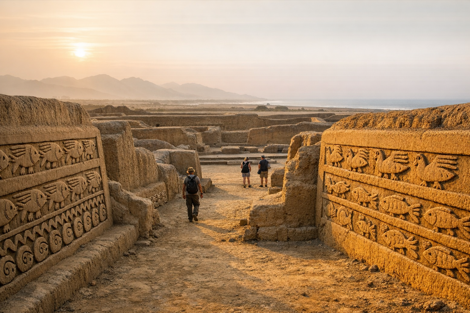
- Chan Chan: The largest adobe city in the pre-Columbian Americas, built by the Chimu empire near Trujillo
- Sipán Royal Tombs: The extraordinary Moche burial complex on the northern coast, Peru’s “Tomb of Tutankhamun”
- Túcume Pyramids: The Valley of the Pyramids near Chiclayo — 26 adobe platforms spanning 200 hectares
Plan your complete Peru archaeological journey with our Peru Ancient Sites Guide. Learn how to combine Kuelap with the northern coast circuit in our Northern Peru Itinerary Guide.
Frequently Asked Questions
How do I get to Kuelap from Chachapoyas?
Most visitors travel from Chachapoyas to Nuevo Tingo (approximately 1.5 hours by road, 65 km), then take the teleférico cable car up to the fortress in 20 minutes. Alternatively, a steeper unpaved road runs to a parking area near the entrance, and hiking trails ascend from the valley. The cable car is by far the most popular and comfortable option.
How long should I spend at Kuelap?
Allow 3 to 4 hours inside the fortress to explore the outer walls, circular houses, El Tintero, and El Castillo at a relaxed pace. Combined with the cable car rides and travel from Chachapoyas, a full day trip is the standard approach. Arriving early avoids afternoon cloud cover that can reduce views.
What is the entry fee for Kuelap?
Entry to the Kuelap Archaeological Zone costs approximately 20 PEN ($5 USD) for foreign visitors, paid at the site. The teleférico cable car is priced separately at around 20 PEN ($5 USD) each way and must be booked or purchased at the Nuevo Tingo station. Bring Peruvian soles as card acceptance is unreliable.
What is the best time to visit Kuelap?
May through September is the dry season and the optimal window. Skies are clearer, the access road is more reliable, and visibility from the fortress walls is excellent. October and April are transitional months with a reasonable chance of clear mornings. December through February brings persistent cloud and rain that can obscure views and close the teleférico on stormy days.
Is Kuelap bigger than Machu Picchu?
By sheer volume of stone, yes. Kuelap is estimated to contain three times more stone construction than the Great Pyramid of Giza, and its outer walls alone enclose a platform measuring roughly 600 meters by 110 meters. Machu Picchu is architecturally richer and better known, but Kuelap's walls and bulk are among the most massive stone structures in the Americas.
Who built Kuelap?
The Chachapoyas, sometimes called the Cloud Warriors, built Kuelap beginning around 900 CE. They were a highland Amazonian people who occupied the rugged cloud forest zone between the Andes and the Amazon basin. Their architecture is distinctive for its use of circular structures decorated with geometric friezes rather than the rectangular forms favored by coastal and highland Andean cultures.
Was Kuelap conquered by the Inca?
Yes, the Inca Empire incorporated Kuelap around 1470 CE after prolonged conflict with the Chachapoyas. The Inca modified the fortress but did not demolish it, adding some rectangular structures inside the compound. Spanish chronicles describe the Chachapoyas as fierce fighters who resisted Inca domination longer than most Andean peoples.
Nearby Ancient Sites
Chan Chan Peru Guide 2026: Chimu Capital & Adobe Citadels
ChimuExplore Chan Chan near Trujillo — the largest pre-Columbian city in the Americas. Discover the Chimu...
Tucume Pyramids Peru Guide 2026: Adobe Huacas & Lambayeque Valley
Lambayeque-Chimu-IncaTucume's 26 adobe pyramids near Chiclayo hold Lambayeque, Chimu, and Inca history. Explore Huaca Lar...

Sipan Royal Tombs Peru Guide 2026: Lord of Sipán & Moche Gold
Cupisnique-Moche-Lambayeque-Inca-Spanish ColonialVisit Peru’s Sipán Royal Tombs to see Moche elite burials, museum treasures, and practical tips for ...