Quick Info
Curated Experiences
Aran Islands Day Trip with Dún Aonghasa Visit
Inis Mór Private Heritage Tour
Aran Islands and Atlantic Cliffs Historical Circuit
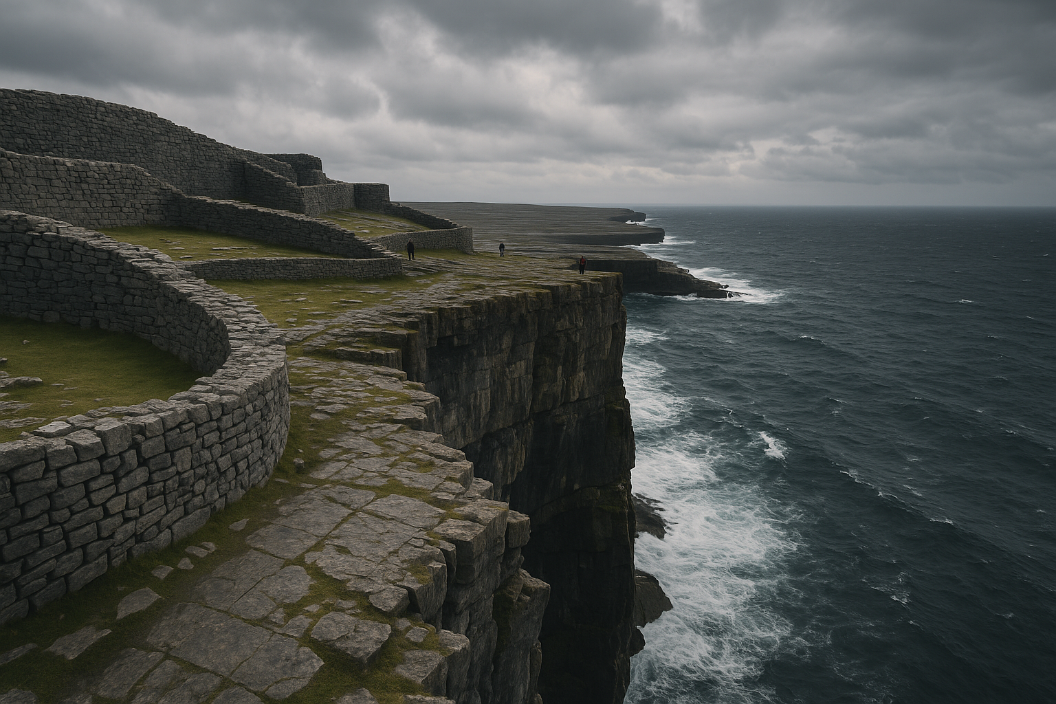
Dún Aonghasa (often anglicized as Dun Aengus) is the most striking prehistoric monument on Ireland’s Atlantic coast - a massive semicircular stone fort perched at the edge of a ninety-meter cliff on Inis Mór, the largest of the Aran Islands. It is not a ruin you visit casually. The walk up, the scale of the walls, and the sheer drop at the fort’s open side combine into something that stays with you long after you leave.
For travelers working through Ireland’s deep-history sites, Dún Aonghasa is essential. It represents a style of Atlantic fortification found nowhere else at this scale, and the setting alone justifies a full day on the island.
Why Dún Aonghasa Matters
Dún Aonghasa is one of the finest surviving examples of a prehistoric cliff fort in western Europe. Its four concentric enclosures, chevaux-de-frise stone defenses, and clifftop position reflect a level of communal planning and labor investment that rivals anything built in Bronze or Iron Age Ireland. This was not a small farmstead wall. It was a statement - defensive, ceremonial, and territorial.
What sets it apart from Ireland’s many ring forts is the relationship between architecture and landscape. The fort’s western wall is the cliff itself. Whether that edge was always exposed or whether erosion has claimed part of the original enclosure remains debated, but the result is a site where human construction and Atlantic geology merge into a single structure. The fort commands views across open ocean to the south and west, and back toward Galway Bay and the Burren to the east. Anyone approaching by sea would have seen this complex from a considerable distance.
UNESCO lists the Aran Islands as a tentative World Heritage Site, and Dún Aonghasa is the centerpiece of that case. For travelers interested in how Atlantic communities built, defended, and signaled their presence, this is a primary source.
Historical Context
The dating of Dún Aonghasa spans roughly 1100 BCE to 500 BCE, though some archaeological evidence suggests activity at the site into the early medieval period. This makes it a multi-phase monument rather than a single construction event. The innermost enclosure likely dates to the Late Bronze Age, while the outer walls and the chevaux-de-frise - upright stone pillars set into the ground to slow attackers - appear to belong to later Iron Age phases.
Excavations in the 1990s led by Claire Cotter recovered evidence of metalworking, animal bone deposits, and pottery that point to both domestic and ritual use. The site was not purely military. The finds suggest feasting, craft production, and possibly ceremonies tied to seasonal cycles or community gatherings.
The name itself links to Aonghus, a figure from Irish mythology associated with the Fir Bolg, a pre-Gaelic people said to have retreated to the Aran Islands after defeat on the mainland. Whether this reflects actual population history or later mythologizing is unclear, but the association gives the site a layered identity - part archaeology, part legend.
Inis Mór’s broader landscape reinforces the picture. The island holds over a dozen other stone forts and early Christian sites, including Dún Eoghanachta and the monastic settlement at Cill Éinne. Dún Aonghasa sits at the top of that hierarchy, both in physical scale and in the labor it would have demanded from a small island population.
What to Prioritize on a First Visit
The Visitor Centre
Start here. The interpretive displays cover the fort’s construction phases, the excavation findings, and the island’s wider archaeological landscape. Fifteen minutes inside gives you the vocabulary to read what you are seeing once you reach the summit. If the centre is closed, at minimum read the outdoor panels before heading up.
The Walk Up
The path from the visitor centre to the fort takes roughly twenty minutes at a steady pace. It climbs through open karst limestone terrain with low-growing wildflowers in spring and summer. The walk itself is part of the experience - it gives scale to the landscape and builds anticipation. Do not rush it.
The Concentric Walls and Chevaux-de-Frise
As you approach the fort, the outer enclosures become visible first. The chevaux-de-frise field between the second and third walls is particularly striking: hundreds of jagged stones set upright to create a barrier zone. Pause here to appreciate the defensive logic. Approaching attackers on foot would have been funneled and slowed before reaching the inner wall.
The Inner Enclosure and Cliff Edge
The innermost platform is the payoff. The wall curves along the cliff’s lip, and the ground drops straight to the Atlantic below. There are no guardrails in several sections. Approach the edge slowly, stay low if windy, and keep well back in wet conditions. The vantage is extraordinary - on clear days you can see the Twelve Bens of Connemara and the full sweep of the Burren coastline.
The Sound
Stand still for a few minutes inside the inner enclosure. The wind and ocean noise at this elevation are distinctive and contribute to the sense of exposure that would have defined life at this site.
Practical Visit Strategy
Getting There
Inis Mór is reached by ferry from Ros an Mhíl (Rossaveal), about 40 minutes west of Galway city, or by a short flight from Connemara Airport. Ferries run year-round but schedules thin in winter. Book in advance during July and August. From the ferry pier at Cill Rónáin, Dún Aonghasa is about 7 km west. You can walk, cycle (bike hire is available at the pier), or take a minibus.
Timing
Aim for the first morning ferry and head directly to the fort. By midday in summer, tour groups arrive and the path gets crowded. Early visits also give you the best chance of calm conditions at the cliff edge. Allow at least two hours for the round trip from the visitor centre, longer if you want to explore the outer enclosures thoroughly.
Best Seasons
May through September offers the most reliable ferry service and longest daylight. April and late September are quieter and still manageable weather-wise. Winter visits are possible but require flexibility - ferries cancel in rough seas, and the exposed path can be punishing in high wind.
What to Bring
Wear boots or shoes with good grip; the limestone is slippery when wet. Bring a windproof layer regardless of the forecast - conditions at the cliff edge are consistently harsher than at sea level. Carry water and a snack if you plan to spend time exploring or continue to other island sites afterward. Sunscreen is relevant in summer despite the latitude.
Route Pairing and Nearby Sites
Dún Aonghasa pairs naturally with other sites across Ireland’s western and midlands heritage corridor. On Inis Mór itself, allow time for Dún Eoghanachta, a smaller but well-preserved circular fort on the island’s south side, and the early monastic remains at Cill Éinne near the pier.
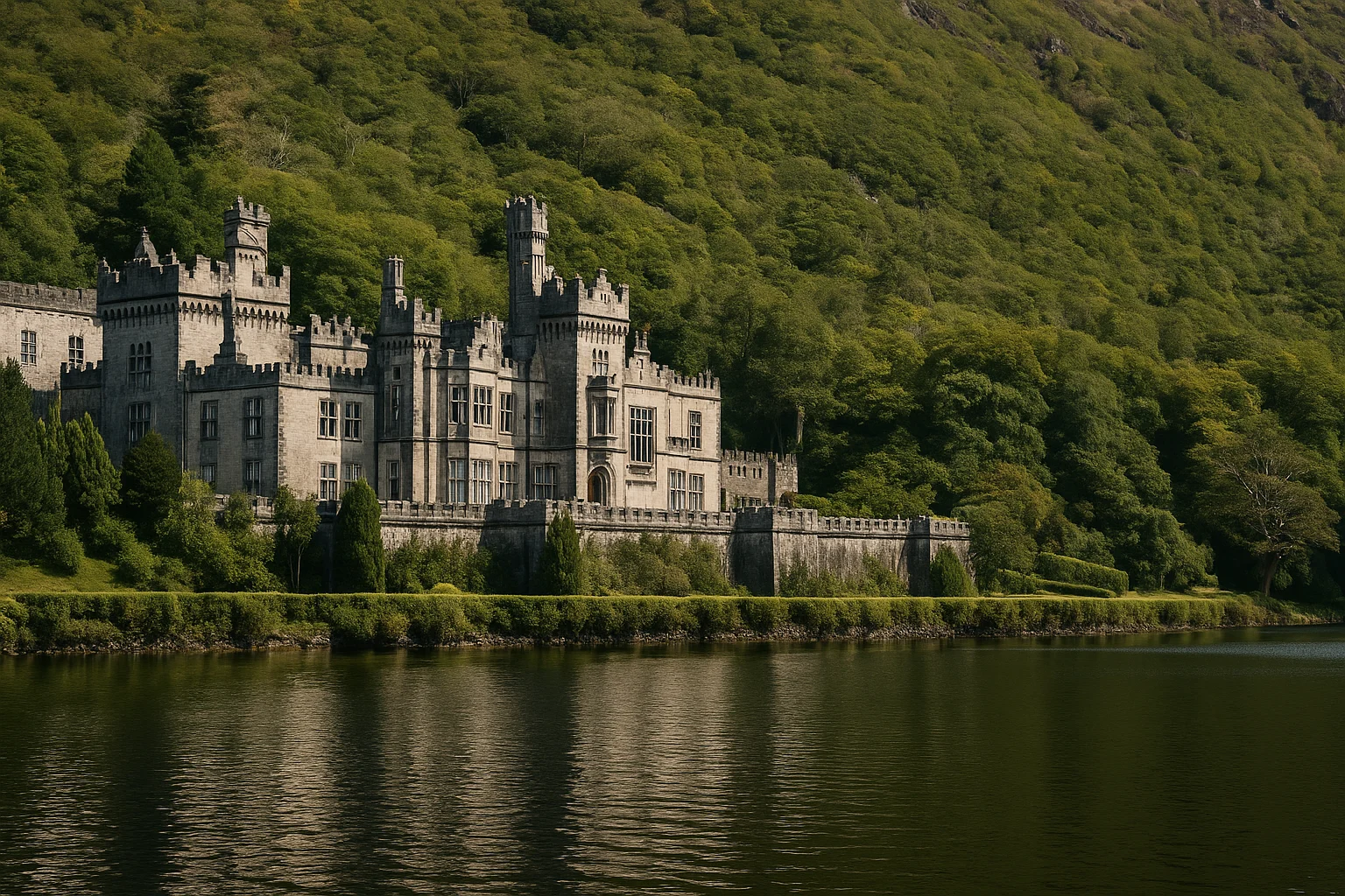
On the mainland, Kylemore Abbey in Connemara offers a contrast in period and function - a nineteenth-century estate turned Benedictine monastery set against a mountain lake. Further south, the Burren and Cliffs of Moher are within a day’s drive and share the same karst geology that defines the Aran Islands.
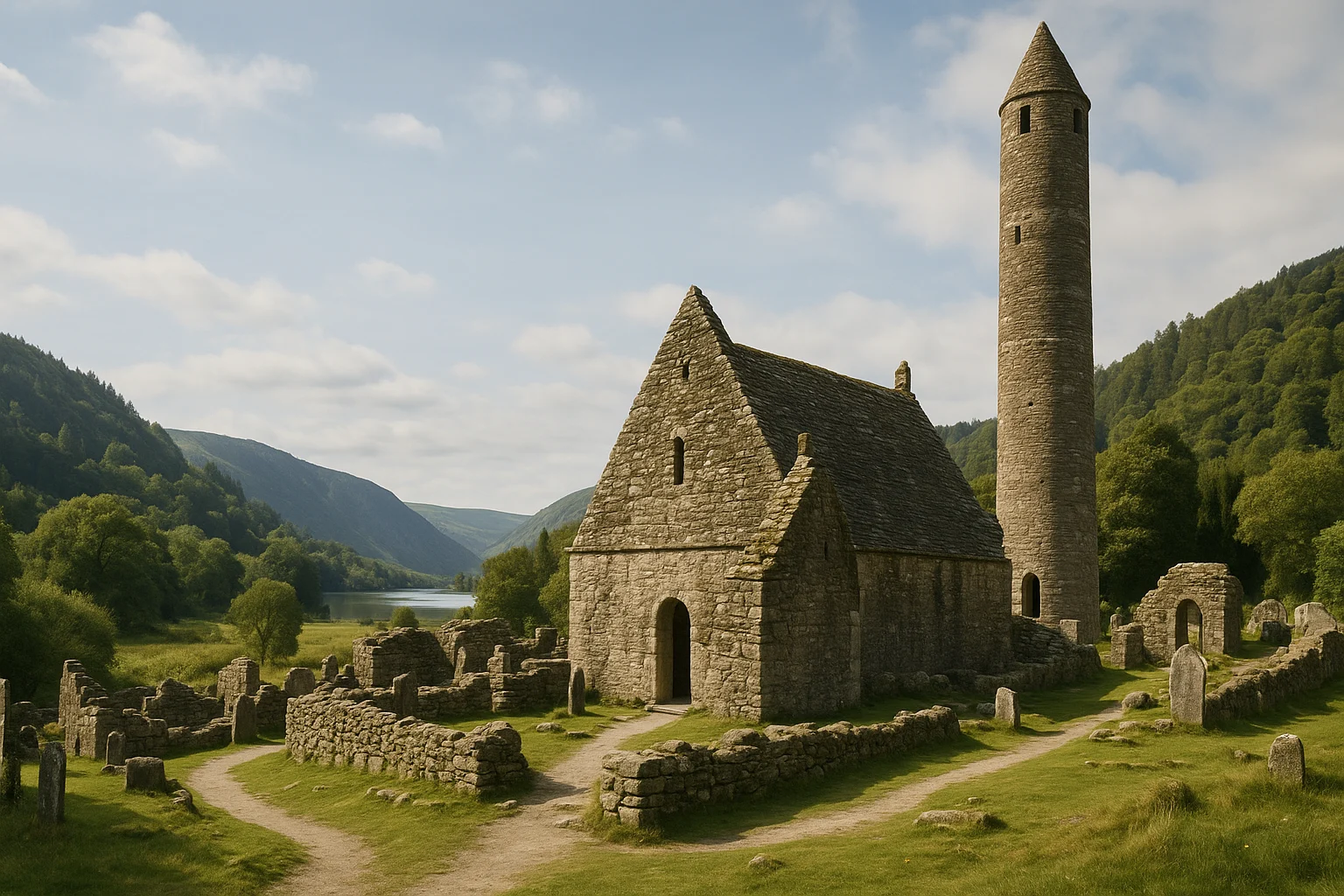
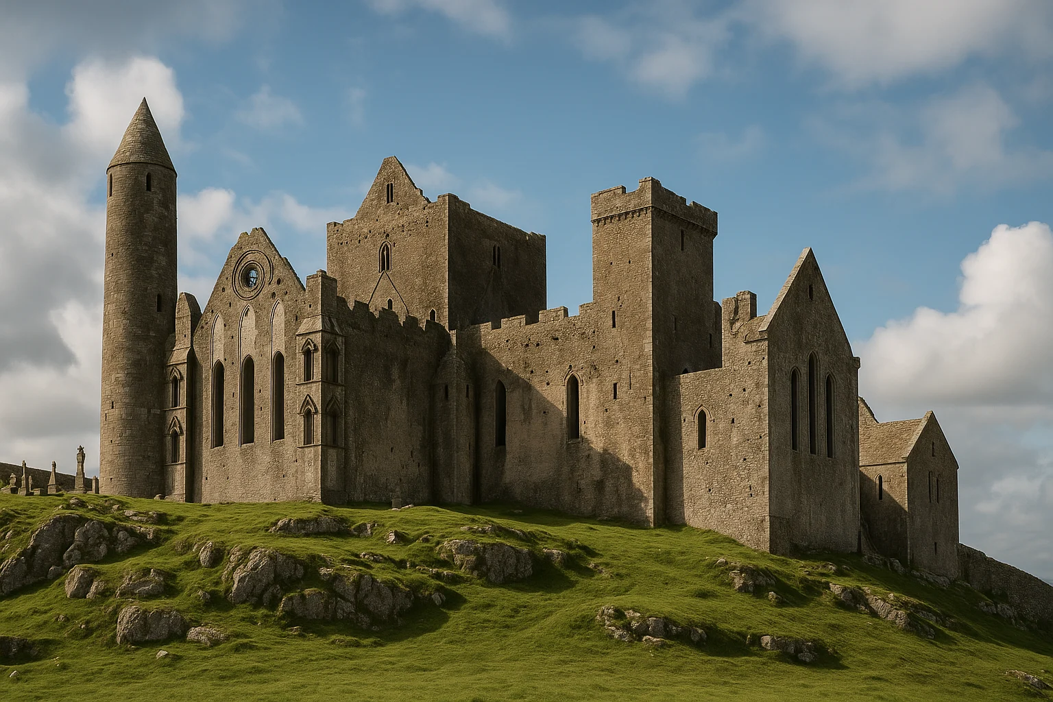
For deeper historical layering, pair with Glendalough in County Wicklow for early medieval monastic life, Newgrange in the Boyne Valley for Neolithic passage tomb engineering, and Rock of Cashel in County Tipperary for the intersection of royal and ecclesiastical power in later centuries. Together, these sites build a chronological arc from prehistoric Atlantic fortification through to medieval Ireland.
Final Take
Dún Aonghasa earns its reputation. It is not a site that has been over-marketed relative to what it delivers. The combination of Bronze and Iron Age construction, raw Atlantic setting, and the physical experience of walking up to a cliff edge with no modern buffer makes it one of the most memorable archaeological visits in Ireland. Give it a full morning, respect the exposed conditions, and build it into a wider western Ireland route. The island itself rewards slow exploration, and Dún Aonghasa is the anchor.
Quick Facts
| Attribute | Details |
|---|---|
| Location | Inis Mór, Aran Islands, County Galway, Ireland |
| Country | Ireland |
| Region | County Galway |
| Civilization | Atlantic Bronze and Iron Age communities |
| Historical Period | Late Bronze Age to Iron Age |
| Established | c. 1100–500 BCE (phased construction and use) |
| Site Type | Cliff fort (cathair) |
| Elevation | ~90 m above sea level |
| Access | Ferry from Ros an Mhíl or flight from Connemara Airport |
| Coordinates | 53.1267, -9.7686 |
Frequently Asked Questions
Is Dún Aonghasa worth visiting?
Yes. It is one of Ireland's most dramatic prehistoric sites, combining major stone fortifications with unmatched Atlantic cliff views.
How much time do you need at Dún Aonghasa?
Plan about 1.5 to 2 hours on-site, plus ferry and island transit time. Most visitors make it part of a full-day Inis Mór trip.
Can you visit Dún Aonghasa as a day trip from Galway?
Yes. Day trips are common, but you should book ferry slots early in peak season and leave buffer time for weather-related schedule changes.
Nearby Ancient Sites
Kylemore Abbey Travel Guide 2026: Connemara Abbey, Walled Garden, and Visit Timing
Modern IrelandPlan a first visit to Kylemore Abbey with practical Connemara timing, estate-route priorities, and c...
Glendalough Travel Guide 2026: Monastic Ruins, Lakes, and Wicklow Day-Trip Plan
Early Medieval IrelandPlan a clear first visit to Glendalough with route advice, monastic-site context, and practical timi...
Rock of Cashel Travel Guide 2026: Cathedral Hill Timing, Access, and County Tipperary Plan
Medieval IrelandPlan your first visit to the Rock of Cashel with practical timing, hilltop route priorities, and eas...