
Quick Info
Curated Experiences
Glastonbury and Wells Small-Group Day Tour
Private Avalon Legends and Glastonbury Tor Experience
Somerset Sacred Sites and Tor Sunset Walk
Glastonbury Tor rises 158 meters above the Somerset Levels, a terraced hill crowned by the roofless shell of St Michael’s Tower. The climb takes roughly 20 minutes, but the layered history beneath your feet spans thousands of years. Iron Age settlements, early Christian monasteries, Arthurian legend, and medieval pilgrimage all converge on this single conical hill. For travelers working through southern England’s heritage landscape, the Tor is one of the most concentrated intersections of mythology, archaeology, and panoramic geography in the country.
Why Glastonbury Tor Matters
The Tor occupies a rare position in English heritage: it is simultaneously a scheduled ancient monument, a site of active archaeological debate, and one of the most symbolically loaded landmarks in British folklore. Its terraced slopes have been interpreted as remnants of a Neolithic labyrinth, a medieval field system, and natural geological erosion. No single explanation has won consensus, which is part of what makes the site compelling.
At the summit, St Michael’s Tower is all that remains of a 14th-century church destroyed during the Dissolution of the Monasteries. The tower’s survival, alone on a bare hilltop visible for miles across the flat Somerset Levels, gives Glastonbury its iconic silhouette. On clear days, the view extends to the Mendip Hills, the Quantocks, and (on exceptional mornings) the Bristol Channel.
For practical purposes, the Tor delivers an unusually high ratio of landscape impact to physical effort. The walk is short, the summit is open, and the surrounding flatland amplifies the sense of elevation. It is one of the few heritage climbs in England where the view alone justifies the visit, independent of any historical interest.
Historical Context
Prehistoric and Roman Layers
Archaeological excavations in the 1960s uncovered evidence of occupation on and around the Tor dating to the Neolithic and Bronze Age periods. Post holes, flint tools, and animal bones suggest the hilltop served as a focal point long before written records. During the Roman period, activity continued, though the nature of use (settlement, ritual, or both) remains debated.
The terracing that wraps around the Tor’s slopes is its most persistent mystery. Some researchers have proposed it as a three-dimensional labyrinth aligned with pre-Christian spiritual practices. Others attribute the ridges to strip farming in the medieval period or natural erosion patterns in the Lias clay and sandstone. The lack of definitive dating keeps this question open.
Early Medieval Monastery and Arthurian Association
By the early medieval period, a monastic community existed on or near the Tor. A 6th-century hermitage is one possibility supported by finds of Mediterranean pottery fragments, suggesting long-distance trade connections unusual for a site this small. The monastery’s association with Glastonbury Abbey, located in the town below, tied the Tor into one of the most important religious networks in Saxon England.
The Arthurian connection runs deep here. Medieval writers identified Glastonbury with the Isle of Avalon, the mythic resting place of King Arthur. In 1191, monks at Glastonbury Abbey claimed to have discovered the graves of Arthur and Guinevere, a claim most modern historians view as a fundraising strategy after a devastating fire. Whether or not the legend holds any historical kernel, it shaped Glastonbury’s identity for centuries and continues to draw visitors today.
The Tower and the Dissolution
The church of St Michael was built on the summit in the 14th century, replacing an earlier structure destroyed by an earthquake in 1275. When Henry VIII dissolved the monasteries in the 1530s, the church was stripped. The last Abbot of Glastonbury, Richard Whiting, was executed on the Tor in 1539 - dragged up the hill and hanged. Only the tower survived, and it has stood alone on the summit ever since, maintained today by the National Trust.
What to Prioritize Onsite
The Ascent Itself
Two main paths lead to the summit. The steeper route climbs directly from the base on the west side, while a longer, more gradual path approaches from Wellhouse Lane to the south. The southern approach passes through a quieter landscape and gives better views of the terracing as you climb. Both routes are on grass, not paved, which matters significantly in wet conditions.
The Summit and Tower
Give yourself at least 20 to 30 minutes at the top. The interior of St Michael’s Tower is open and accessible, with carved details still visible on the stonework. Walk the full perimeter of the summit plateau to take in the 360-degree view. To the west, the flat geometry of the Somerset Levels stretches toward the coast. To the east, the town of Glastonbury sits below with the ruined Abbey visible among the rooftops.
The Terracing
On the descent, pay attention to the terraced ridges wrapping around the hill. Whether agricultural, ritual, or geological in origin, they are easier to appreciate from ground level than from the summit. The western face shows the most pronounced ridges.
Practical Visit Strategy
Timing
The best months for visiting are April through June and September through October. Spring offers wildflowers on the slopes and longer daylight without summer crowds. Early autumn brings clearer atmospheric conditions for distant views. Summer weekends can feel congested on the narrow summit.
Arrive early in the morning for the quietest experience. Weekday mornings before 9:00 are reliably uncrowded. Late afternoon light (roughly 4:00 to 6:00 PM in summer months) produces the best photographic conditions, with the tower backlit against western skies.
Logistics
The Tor is managed by the National Trust and is free to access year-round. There is no dedicated car park at the base. Most visitors park in Glastonbury town (pay-and-display lots along Street Road or Magdalene Street) and walk roughly 15 to 20 minutes to the trailhead. A small rural lane car park exists closer to the southern approach, but spaces are limited.
There are no facilities on the Tor itself. No toilets, no shelter, no water. Plan accordingly, especially with children.
What to Bring
- Shoes with proper grip. The grass paths become slippery in any moisture, and the descent is steeper than it appears.
- A windproof layer regardless of season. The summit is fully exposed and wind accelerates noticeably above the surrounding terrain.
- Water and sun protection in warmer months. There is no shade on the ascent or at the top.
- Budget 60 to 90 minutes total, including the walk from town parking if applicable.
Route Pairing and Nearby Sites
Glastonbury Tor fits naturally into a broader Somerset and Wiltshire heritage circuit. In the town itself, Glastonbury Abbey is the essential pairing, offering the monastic and Arthurian context that the Tor’s bare summit only implies. The Abbey ruins, Lady Chapel, and claimed burial site of Arthur all connect directly to the Tor’s story.
For prehistoric landscape context, drive north to Avebury Stone Circle, where the scale of Neolithic engineering dwarfs most English heritage sites. Nearby Silbury Hill and West Kennet Long Barrow round out a full day of prehistoric exploration.
Stonehenge lies roughly 45 minutes east and provides a sharper Neolithic contrast to the Tor’s medieval and mythological character. For travelers following the Arthurian thread, Tintagel Castle on the Cornish coast pairs with Glastonbury as the two most prominent legendary sites associated with the Arthur cycle.
The Roman Baths in Bath sit less than 30 minutes north and add a Roman-period layer to any Somerset itinerary.
Final Take
Glastonbury Tor rewards visitors who arrive with context. Without it, the site is a pleasant hill with a photogenic tower. With it, every terrace, every stone in the tower wall, and every sightline across the Levels carries accumulated meaning stretching back millennia. Come with good shoes, low expectations for facilities, and enough time at the summit to let the landscape settle. The Tor does not demand a full day, but the half-day it asks for is among the most atmospheric you will spend in southern England.
Quick Facts
| Attribute | Details |
|---|---|
| Location | Glastonbury, Somerset, United Kingdom |
| Country | United Kingdom |
| Region | Somerset |
| Civilization | Early Medieval England |
| Historical Period | Neolithic through present |
| St Michael’s Tower Built | c. 14th century (on older sacred hill) |
| Managed By | National Trust |
| Admission | Free, open year-round |
| Summit Elevation | 158 meters (518 feet) |
| Average Visit Time | 60 to 90 minutes |
| Coordinates | 51.1458, -2.6868 |
Frequently Asked Questions
How difficult is the walk up Glastonbury Tor?
The climb is short but steep. Most visitors can manage it with moderate fitness in 20 to 35 minutes, depending on weather and stops.
Is there an entry fee for Glastonbury Tor?
The Tor itself is generally open access and free to walk, though nearby parking and local attractions may have separate costs.
When is the best time to visit Glastonbury Tor?
Early morning and late afternoon usually offer fewer crowds and better light. In wet or windy weather, the slope can be slippery and exposed.
Nearby Ancient Sites
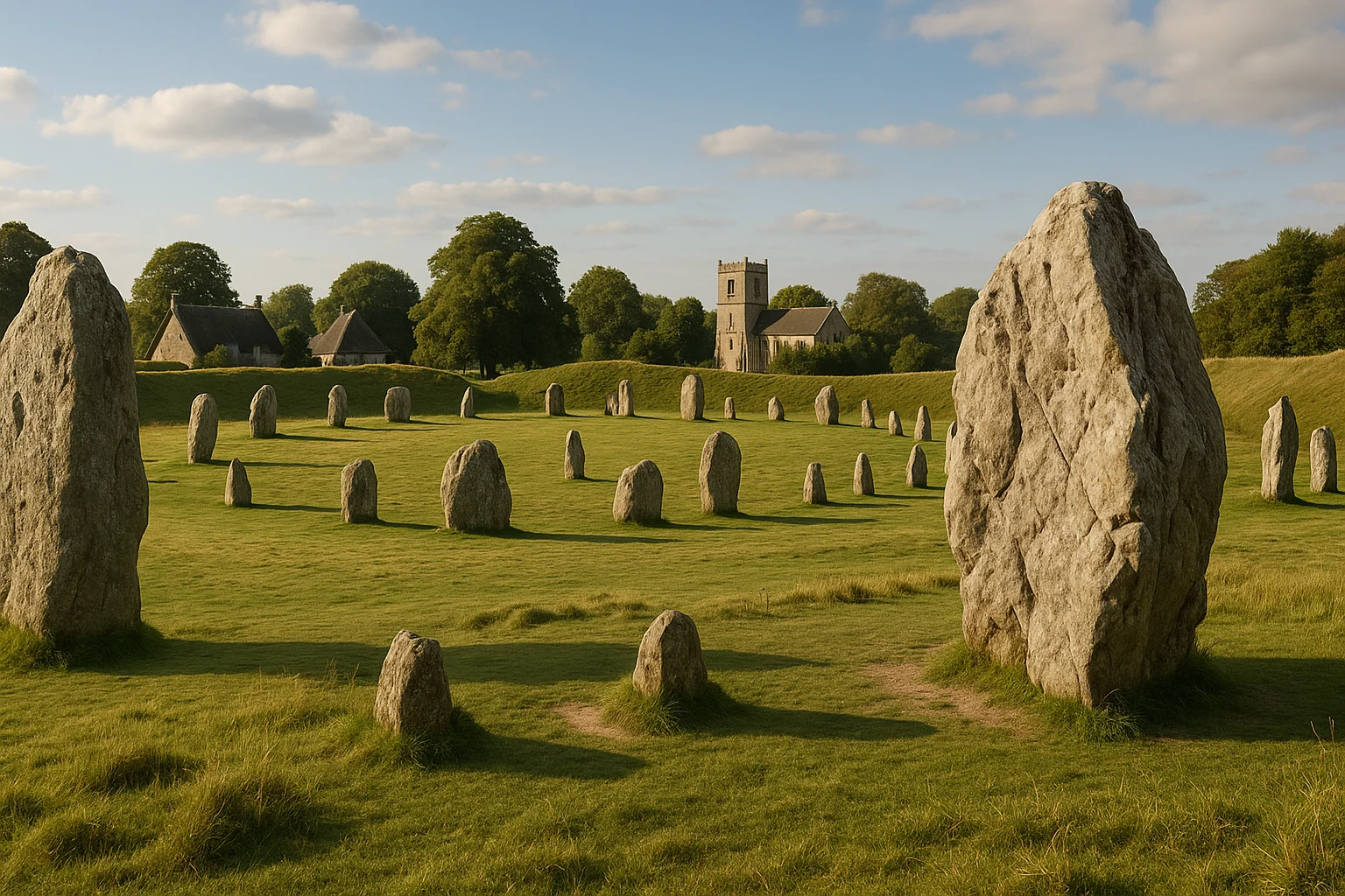
Avebury Stone Circle Travel Guide 2026: Best Walk Routes, History, and Visit Planning
Neolithic BritainPlan a stronger visit to Avebury Stone Circle with practical walking routes, landscape context, and ...
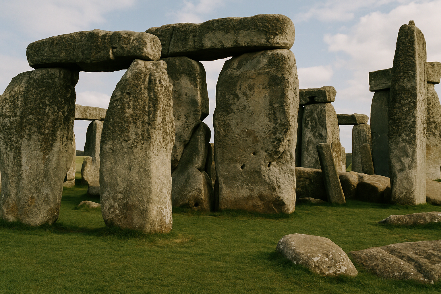
Stonehenge Travel Guide 2026: Solstice History, Tickets, and Day-Trip Planning
Neolithic and Bronze Age BritainPlan a smooth visit to Stonehenge with practical ticket timing, transport options from London and Ba...
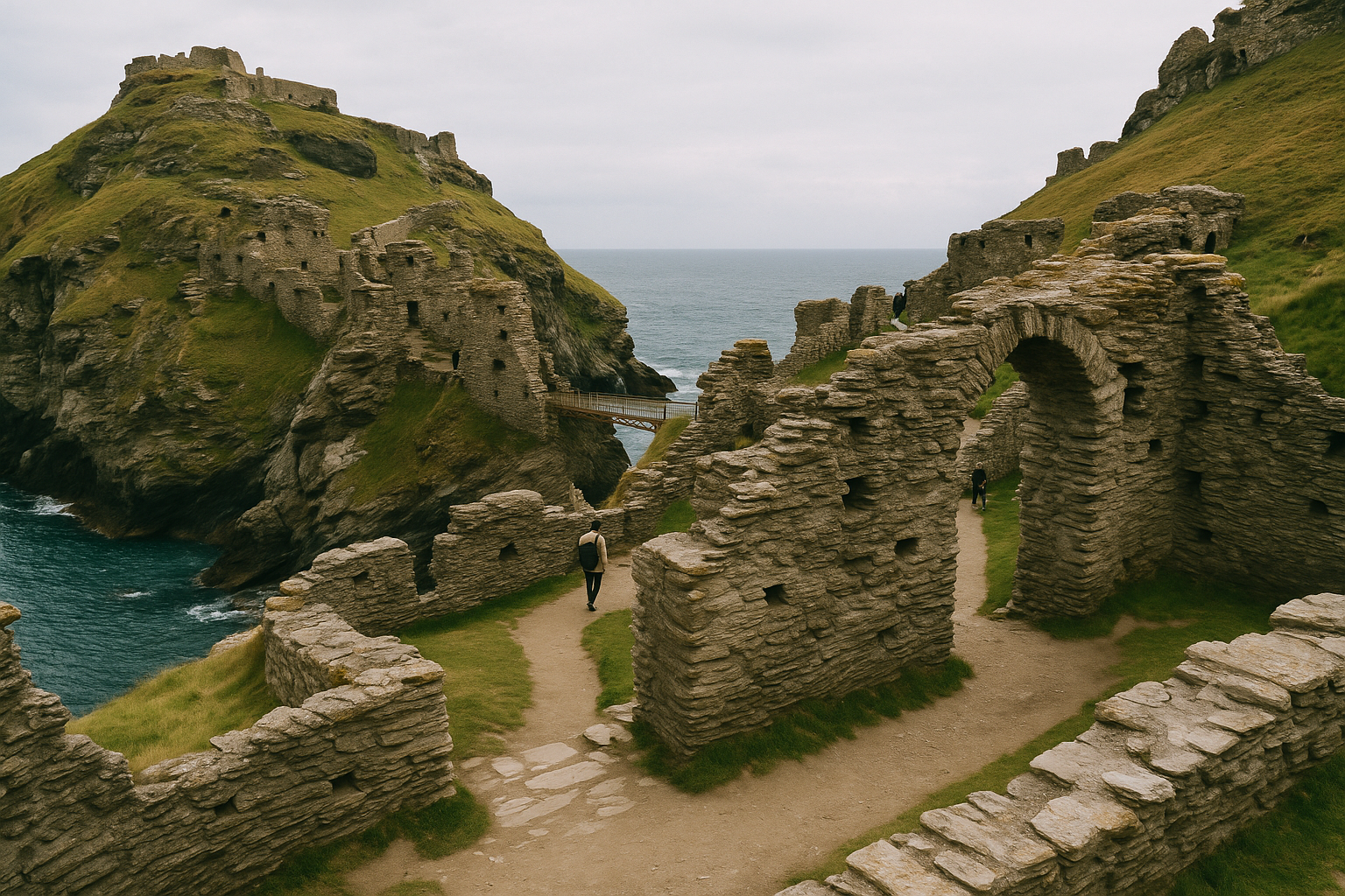
Tintagel Castle Travel Guide 2026: Coastal Ruins, Arthurian Legends, and Smart Visit Planning
Early Medieval BritainPlan your Tintagel Castle visit with practical timing, cliff-path tips, and clear context on the sit...