Quick Info
Curated Experiences
Caral and Paramonga Fortress Full-Day Tour from Lima
Archaeological Route to Caral, Bandurria and Paramonga
Private North Coast Heritage Tour: Caral and Paramonga
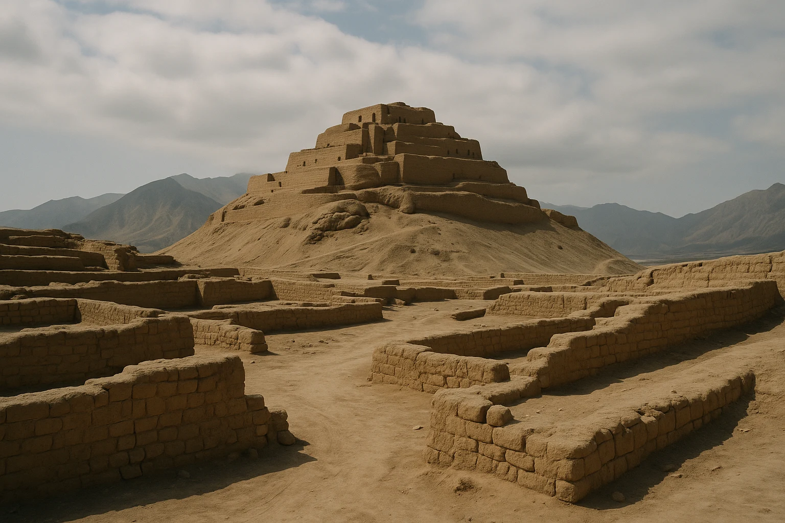
On Peru’s north-central coast, where desert hills break open into irrigated valley fields, Huaca Fortaleza Paramonga rises from the plain like a terraced clay citadel. It does not announce itself with carved stone or mountain drama. Instead, it dominates through form: heavy adobe walls, stacked levels, long access ramps, and sightlines that still command the Pativilca corridor centuries after its political purpose faded. For travelers building a huaca fortaleza paramonga peru travel guide into a larger itinerary, that first visual contrast is unforgettable—earth architecture set against green agriculture and Pacific light. Paramonga’s significance is not just architectural; it is historical layering made visible. The fortress is usually linked to late Chimu expansion, then folded into Inca coastal administration, and later absorbed into a colonial landscape transformed by plantation agriculture and road networks. You can feel those transitions as you walk the site. Ancient Travels recommends Paramonga for travelers who want to understand how power worked on the coast: not only in temples and ritual centers, but in fortified nodes that controlled movement, labor, and water-rich valleys. This guide covers the site’s timeline, key monuments, transport logistics from Lima and Barranca, seasonal planning, and how to combine Paramonga with nearby destinations like Caral for a coherent archaeology day. ## History: Where Coastal Power Took Shape
Valley foundations before the fortress (before c. 1200 CE)
Long before the visible fortress walls were built, this part of Peru’s coast had already seen millennia of settlement, irrigation, and social coordination. Nearby valleys in Supe and Pativilca supported farming communities that learned to organize water in one of the world’s driest coastal environments. The region sat within wider exchange networks linking fishing settlements, inland producers, and ceremonial centers. By the end of the first millennium CE, control of corridors between valleys mattered politically as much as control of ritual spaces. Paramonga’s location—at a strategic threshold between productive land and transport routes—made it a natural place for concentrated authority. Even if its monumental phases came later, the geography had long invited defensive and administrative architecture. ### Chimu frontier strategy and major construction (c. 1200-1470 CE)
Most archaeological interpretations place Paramonga’s primary construction in the Late Intermediate Period, when the Chimu polity expanded influence southward from its northern core. Chimu builders were experts in adobe monumentalism, and Paramonga reflects that coastal engineering logic: thick battered walls for stability, terraced levels for controlled ascent, and enclosed compounds for regulating movement. Rather than a single ceremonial pyramid, the complex appears to have operated as a hybrid military-administrative center. It likely functioned as a checkpoint, storage node, and visual marker of state authority over routes that connected river valleys and agricultural production zones. In this era, architecture was political messaging. Paramonga’s profile communicated surveillance and command before anyone reached its gates. ### Inca incorporation and adaptation (c. 1470-1532 CE)
As the Inca Empire pushed into the north-central coast in the late 15th century, it commonly integrated existing power centers rather than replacing them wholesale. Paramonga fits that broader imperial method. Scholars continue debating how much structural remodeling occurred under Inca management, but the strategic logic is clear: a fortress already positioned above a productive corridor would have been too valuable to ignore. Under Inca rule, sites like Paramonga likely shifted from regional strongholds to nodes in larger logistical systems tied to road movement, labor administration, and tribute flow. The place remained useful because its core design—control through elevation and enclosure—was adaptable across regimes. What changed most was scale of governance, not the basic utility of the architecture. ### Colonial disruption and changing valley economies (1532 CE onward)
Spanish conquest altered the political world that made Paramonga essential. Colonial administration reorganized settlement, labor, and landholding across the coast, and fortified pre-Hispanic centers gradually lost direct governing function. Unlike some sacred compounds converted into churches or colonial institutions, Paramonga moved into a long afterlife of partial abandonment, local memory, and landscape reuse. The valley remained economically important, eventually tied to large-scale sugar production and modern agro-industry. That continuity matters when you visit today: the fortress is not isolated in empty desert, but embedded in a working agricultural region that experienced new forms of imperial extraction. Paramonga therefore preserves more than walls; it preserves a vantage point on how different states repeatedly claimed the same corridor. ### Archaeology, conservation, and current interpretation (20th century-present)
Systematic archaeological study expanded during the 20th century as Peruvian researchers and cultural authorities mapped fortified coastal sites with greater precision. At Paramonga, conservation has focused on stabilizing adobe surfaces, managing visitor circulation, and limiting erosion in vulnerable upper sectors. Adobe requires continuous care; wind, occasional moisture, and uncontrolled foot traffic can degrade walls quickly. Current interpretation emphasizes Paramonga as one of Peru’s clearest examples of late pre-Hispanic frontier architecture, where defensive and administrative goals overlap. It may not be as globally marketed as Machu Picchu or Chan Chan, but for travelers and researchers interested in coastal statecraft, Paramonga is indispensable evidence. It shows how authority could be built in earth, geometry, and vantage rather than in imperial stone spectacle. ## The Key Monuments: What to See at Huaca Fortaleza Paramonga
The outer fortified envelope
The first monument is the outer defensive envelope itself: broad adobe walls with sloped faces, controlled entry points, and a perimeter that still reads as strategic design at first glance. These walls are not decorative architecture; they are engineered barriers meant to slow approach and concentrate movement through specific corridors. Their battered geometry improves structural stability while increasing defensive advantage, and even weathered sections retain impressive mass. Walking this perimeter before climbing inward helps you read the fortress as a system, not a ruin fragment. In morning light, subtle tonal variations in the clay reveal construction phases and repair patches, offering a surprisingly rich visual experience for photographers who look closely. ### The terraced citadel and ascent ramps
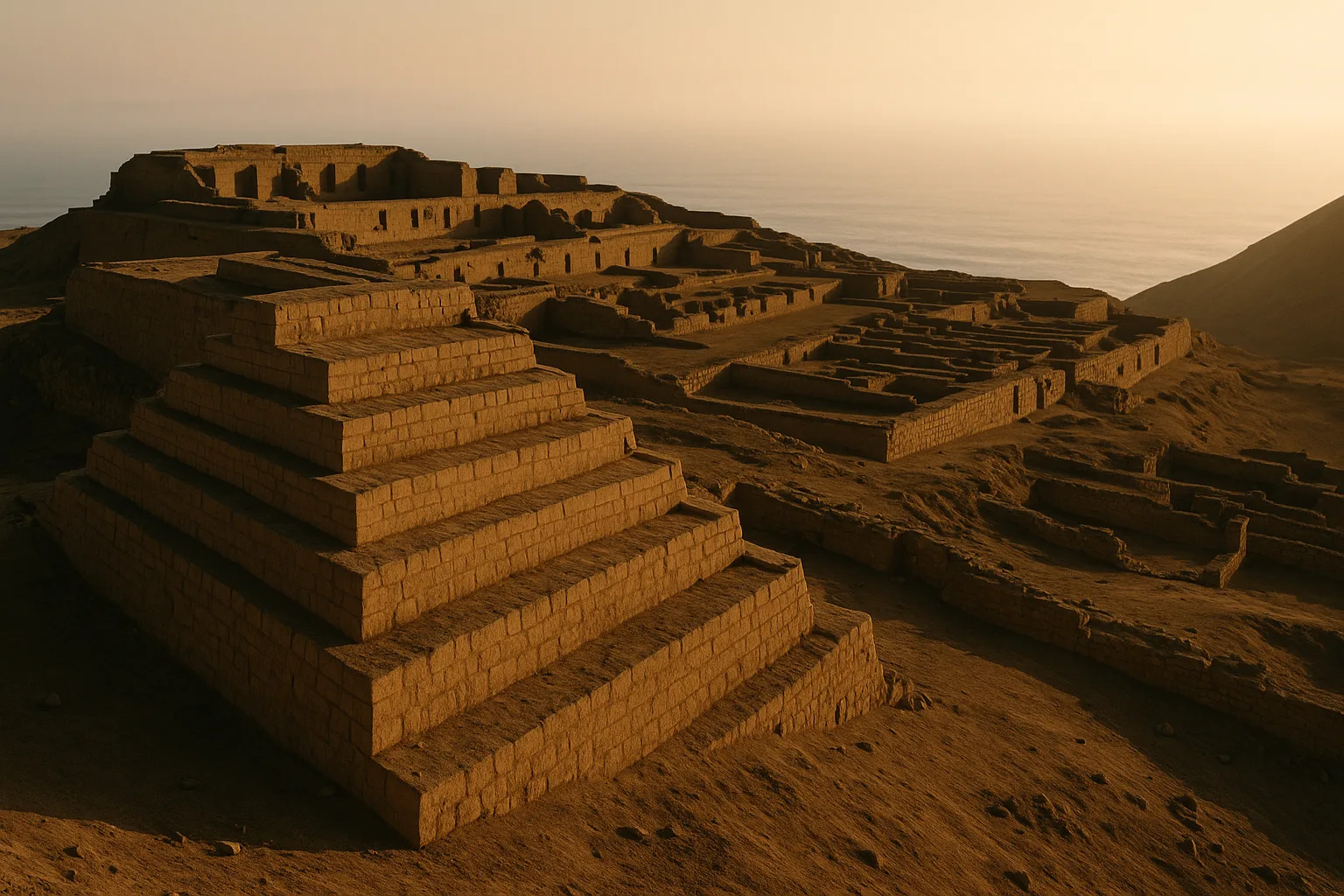
Inside the compound, Paramonga’s defining feature is its multi-level terraced citadel linked by long ramps. Unlike narrow stair-heavy ceremonial complexes, this ascent feels infrastructural. Ramps allow movement of people, supplies, and possibly administrative cargo between levels with less bottleneck risk. As you climb, the architecture creates controlled thresholds: open segments that suddenly compress into narrow transitions, then release into broader platforms. This sequencing suggests practical governance as much as defense—an environment designed to direct where people can pause, gather, or proceed. It also creates excellent visual lines for visitors. Late-afternoon side light sharpens ramp edges and produces layered shadows that make the fortress read almost like an architectural model at landscape scale. ### Inner compounds and patio organization
The inner compounds are easy to overlook, but they are crucial for understanding function. Surviving walls define enclosed patios and room clusters that likely supported storage, supervision, and controlled access for personnel. Even where upper structures are lost, circulation logic remains legible: some passages narrow intentionally, some patios open into transitional spaces, and some elevated sectors clearly restricted direct entry. This pattern suggests a working administrative complex rather than a single symbolic platform. Paramonga managed flows of people, goods, and authority. If you pause in these areas instead of rushing to the highest viewpoint, the site becomes less “mysterious ruin” and more intelligible built policy. ### High lookout terraces over the Pativilca Valley
Near the top, the lookout terraces deliver the fortress’s core argument in one panoramic sweep. You see the valley floor, modern roads, agricultural parcels, and the narrow geographic corridors that connect coast and interior. That view clarifies why successive powers valued this location: it enabled oversight and rapid response in a productive landscape. The visual contrast is striking—ochre adobe foreground against green fields and pale desert ridges. This is the best zone for wide compositions and contextual photos that explain Paramonga’s role better than any isolated close-up. If conditions are clear, spend extra time here and watch how changing sun angle reshapes the valley grid. ### The surrounding engineered landscape
Paramonga’s final key “monument” is not one structure but the integrated landscape of fortress, valley routes, and agricultural terrain. The site’s importance comes from relationships: wall to ridge, terrace to approach path, viewpoint to cultivated plain. In that sense, Paramonga resembles an operational machine built from earth architecture and topographic intelligence. Travelers expecting ornate iconography can initially underrate it, but the reward here is different. This is one of Peru’s strongest places to study how political control was embedded in movement and sightlines. Once you read the whole composition, Paramonga feels less like an isolated huaca and more like a living map of coastal governance. ## Getting There: Transportation and Access
Paramonga is reachable with straightforward planning, but because distances are long from Lima, your transport choice strongly affects comfort, timing, and how much of the site you enjoy. ### From Lima
Most travelers begin in Lima, using the Panamericana Norte toward Barranca and Paramonga. - Intercity bus + local transfer: Buses to Barranca generally take 3.5-4.5 hours depending on terminal traffic and departure time. Typical fares are 25-55 PEN ($7-15 USD). From Barranca, continue by taxi or colectivo to Paramonga in 20-30 minutes for around 8-20 PEN ($2-5 USD). - Private taxi or driver: Door-to-door private transport from Lima usually takes 3.5-4.5 hours each way and offers the best flexibility for photography timing. Full-day hire often falls between 450-750 PEN ($120-200 USD), depending on vehicle type and wait time. - Organized archaeology tour: Shared and private day tours that combine Caral and Paramonga are widely marketed. They reduce planning friction but involve early departures and late returns; prices commonly range from 95-185 USD. ### From Barranca or Supe
If you stay overnight in Barranca or Supe, Paramonga becomes a relaxed half-day visit with better control over heat and light. - Taxi: From Barranca center, expect about 20-30 minutes and 15-30 PEN ($4-8 USD) one way. - Colectivo/minibus: Inexpensive corridor options generally cost 3-8 PEN ($1-2 USD), but frequencies vary outside peak commute times. - Rental car: Self-driving from Lima is practical for independent itineraries; roads are generally straightforward and informal parking is usually available near the site area. ### Admission and Hours
Paramonga is typically open during daylight hours, usually around 08:00-17:00, with occasional local adjustments on holidays or maintenance days. Entrance is usually 5-10 PEN ($1.35-2.70 USD), and cash is the safest payment method. Card acceptance should not be assumed. The most comfortable visiting window is early morning or late afternoon, when temperatures are lower and adobe textures photograph better. Midday can feel significantly hotter than forecasts suggest because of reflected heat and minimal shade. ## When to Visit: Seasonal Considerations
Spring (September-November)
Spring is often the ideal season for Paramonga. Typical daytime temperatures sit around 19-27°C (66-81°F), with cleaner skies than winter and manageable sun exposure for long walks on exposed terraces. Crowds remain moderate, and photography benefits from steadier visibility. If you are combining Paramonga with Caral, spring gives the most balanced full-day conditions. ### Summer (December-March)
Summer brings stronger heat and brighter overhead light, commonly 24-32°C (75-90°F) at midday. The site usually remains less crowded than major Peruvian icons, but thermal comfort drops quickly on upper levels. Start early, carry extra water, and plan your climb before noon or later in the afternoon. Lightweight long sleeves can be more effective than short sleeves under intense sun. ### Autumn (April-May)
Autumn is an excellent shoulder season, often with temperatures near 20-28°C (68-82°F). Crowds thin after summer weekends, road travel remains smooth, and the site feels calmer for slow architectural reading. This is a strong choice for travelers who prioritize pacing, low stress, and cleaner compositions without many people in frame. ### Winter (June-August)
Winter on Peru’s coast can bring overcast mornings and garúa humidity, though Paramonga often remains walkable and pleasant. Expect about 16-23°C (61-73°F), with low crowd pressure and comfortable hiking temperatures. The tradeoff is flatter light during heavily overcast periods. Bring a light wind layer and be patient; visibility often improves by midday. ## Combining Huaca Fortaleza Paramonga with Barranca and Caral
Paramonga is best experienced as part of a broader coastal archaeology sequence, where each site explains a different phase of political organization. A strong itinerary begins with an early northbound departure and arrival at Caral-Supe by 8:30 AM. Spend around two hours there to understand preceramic urban planning, monumental platforms, and the valley systems that supported one of the earliest complex societies in the Americas. By 11:30 AM, move toward Supe or Barranca for lunch; local cevicherías and menú spots near central avenues keep you on schedule without requiring a long detour. Continue to Paramonga around 1:30 PM, when transfer roads are calmer and the fortress starts to gain directional light for texture-rich photography. Give yourself at least 90 minutes to walk the perimeter, ascend the ramps, and pause at the upper viewpoint. By 3:30 PM or 4:00 PM, you can decide between a same-day return to Lima or an overnight in Barranca, which removes evening highway fatigue and creates room for another nearby stop the next morning. If you choose the overnight option, add a short coastal morning in Puerto Supe before driving south, or a stop near Bandurria if routing allows. In total, expect 12-14 hours for a same-day Lima loop, or a more comfortable 1.5-day journey with one night in Barranca. ## Practical Information
What to Bring
- Sun protection: Hat, sunscreen, and sunglasses are essential because upper sectors offer little shade. - Water: Carry at least 1 liter per person in cooler months and more in summer. - Footwear: Closed shoes with grip are important on dusty ramps and uneven adobe surfaces. - Cash: Bring small PEN notes for entry fees, local transport, and simple snacks. - Camera or phone battery: You will likely shoot more than expected because the geometry rewards multiple angles. ### Dress Code and Etiquette
There is no strict formal dress code, but practical and respectful behavior matters. Avoid climbing on fragile wall crests, stepping beyond marked paths, or treating unstable edges as photo platforms. Adobe architecture erodes quickly under pressure, and preservation depends on controlled circulation. If site staff or local guides offer route guidance, follow it—especially near upper levels where footing can degrade seasonally. ### Accessibility
Accessibility is limited. Lower sectors may be manageable for some travelers with reduced mobility, but the core experience involves uneven ramps, loose surfaces, and changes in elevation that are difficult for wheelchairs or visitors needing continuous rail support. There is minimal formal accessibility infrastructure. Travelers with mobility concerns should plan a lower-level and viewpoint-focused visit rather than a full upper ascent. ## Why Huaca Fortaleza Paramonga Matters
Huaca Fortaleza Paramonga matters because it expands how you understand ancient Peru. So much global attention focuses on highland stone masterpieces that coastal earthen architecture can seem secondary at first glance. But Paramonga reveals a different intelligence: power expressed through terrain control, engineered movement, and visible command over fertile valleys. Its walls are austere, yet intensely communicative. From the upper terraces, you can read the site as a political instrument. It watched routes, structured access, and made authority legible to everyone traveling through the corridor. Successive regimes—Chimu, Inca, then colonial systems—reused the same geography because the strategic logic never disappeared. That continuity gives the fortress unusual emotional force: you are standing in a place where statecraft outlasted any one state. For travelers, Paramonga offers a rare reward. It does not overwhelm with ornament; it teaches you to see structure, landscape, and history as one system. You leave with a clearer sense of how empires were managed at their edges—and why the quiet, wind-cut citadel above the valley is one of coastal Peru’s most important stories. Quick Facts
| Attribute | Details |
|---|---|
| Location | Paramonga District, Barranca Province, Lima Region, Peru |
| Ancient Name | Commonly known today as Fortaleza de Paramonga |
| UNESCO Status | Not individually inscribed on the UNESCO World Heritage List |
| Established | c. 1200 CE fortified complex |
| Distance from nearest hub | ~15 km from Barranca (20-30 minutes by road) |
| Entry Fee | Usually 5-10 PEN ($1.35-2.70 USD) |
| Hours | Typically around 08:00-17:00 (verify locally) |
| Best Time | Spring and autumn, especially early morning or late afternoon |
| Suggested Stay | 1.5-2 hours on site |
Explore More Peru
- Caral-Supe: Pair Peru’s earliest urban center with Paramonga’s late fortified architecture in one coherent valley story. - Pachacamac: Explore a major coastal pilgrimage complex near Lima for broader context on ritual landscapes. - Huaca Pucllana: See adobe monumental architecture inside modern Lima before or after your northbound route. - Cerro Sechin: Continue into Ancash for carved stone iconography and a different expression of ancient authority. Plan your full route with our Peru Ancient Sites Guide.
Frequently Asked Questions
How much time should I plan at Huaca Fortaleza Paramonga?
Most travelers need 1.5 to 2 hours for a full circuit, including the lower enclosure, sloped ramps, and upper viewpoints. If you like architecture photography, allow another 30 minutes for changing light. When combined with Caral, plan a full-day outing from Lima.
Can I visit Paramonga as a day trip from Lima?
Yes, but it is a long day. Expect roughly 3.5 to 4.5 hours each way by road, depending on traffic and your transport type. Many travelers improve the experience by overnighting in Barranca, then visiting Paramonga in cooler morning or afternoon light.
What are the ticket price and opening hours at Paramonga?
Entry is usually inexpensive, commonly around 5 to 10 PEN (about $1.35 to $2.70 USD), though local pricing can change. Typical hours are around 08:00 to 17:00 in daylight. Bring cash in small notes because card payment is not always available.
How do I get to Paramonga from Barranca or Supe?
From Barranca, taxi rides usually take 20 to 30 minutes and are straightforward for independent travelers. Budget travelers can use colectivos on the corridor, though departures are less predictable later in the day. From Supe or Caral areas, most visitors continue by taxi or pre-arranged private car.
What will I actually see at Huaca Fortaleza Paramonga?
You will see a large adobe fortress with battered outer walls, stacked terraces, interior compounds, and long ramps that connect upper levels. The highest sections open to wide views over the Pativilca Valley and surrounding fields. The site is especially valuable for understanding how late pre-Hispanic states organized defense and administration on the coast.
Is Paramonga safe for independent visitors?
Paramonga is generally safe in daylight with normal travel precautions. The main risk is physical, not security-related: surfaces are uneven, dusty, and sometimes steep. Wear stable shoes, carry water, and avoid climbing on fragile wall edges.
Nearby Ancient Sites
Caral-Supe Peru Guide 2026: Sacred Pyramids & the First Andean City
Norte-Chico-CaralVisit Caral-Supe in Peru, the oldest known city in the Americas, with practical transport from Lima,...
Pachacamac Peru Guide 2026: Oracle Temple, Pilgrimage Roads & Lima Coast
Lima-Wari-Ychsma-IncaExplore Pachacamac near Lima: ancient oracle temples, multi-civilization coastal history, practical ...
Huaca Pucllana Peru Guide 2026: Lima Adobe Pyramid & Lima Culture
Lima-Ychsma-IncaExplore Huaca Pucllana in Lima: pre-Inca adobe pyramid architecture, museum circuit, practical entry...
Cerro Sechín Peru Guide 2026: Relief Monoliths & Casma Valley
Sechin-Casma-initial-AndeanPlan your visit to Cerro Sechín in Peru with history, carved monolith highlights, transport from Cas...