Quick Info
Curated Experiences
Kuelap and Chachapoyas Full-Day Tour
Gocta Waterfall Trek from Chachapoyas
Private Amazonas Archaeology Day Tour
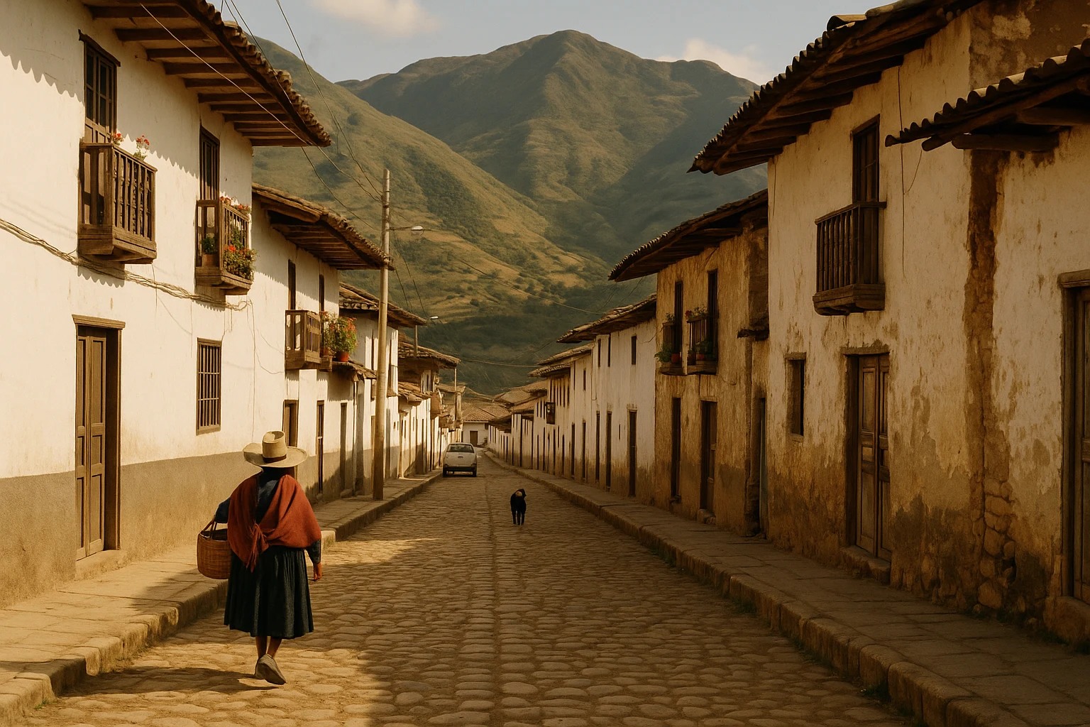
In northern Peru, most first-time visitors arrive in Amazonas with one name in mind: Kuelap. Then they drive into Leymebamba and realize the region is bigger, quieter, and stranger than the headline sites suggest. This small mountain town sits in a fold of green ridges where cloud, light, and rain move fast across the valley. You can hear river water below the road, church bells from the plaza, and little else. Leymebamba, Peru is not a monumental ruin in the conventional sense. It is a base camp, a threshold, and one of the best places in the country to understand the people behind the stones. For travelers who care about context as much as spectacle, this is where the Chachapoyas world becomes legible.
At Ancient Travels, we recommend Leymebamba as the interpretive anchor for the southern Amazonas circuit: visit the museum first, then read the surrounding landscape differently. Instead of seeing isolated attractions, you begin to see a connected cultural geography of fortified ridges, cliff tombs, ritual routes, and colonial-era road links that still shape movement today. This guide covers the town’s historical layers, the sites and monuments you should prioritize, exactly how to get there from Chachapoyas and larger hubs, practical details for tickets and timing, and a realistic way to combine Leymebamba with Kuelap, Revash, and cloud-forest viewpoints without rushing the experience.
History: Frontier Town Between Cloud Kingdoms and Colonial Roads
Chachapoyas landscape before Spanish settlement (c. 900-1532 CE)
Long before Leymebamba appeared on colonial maps, the valley belonged to the wider world of the Chachapoyas cultures, whose communities occupied high ridges and cloud-forest corridors across what is now Amazonas. Political organization was decentralized, but architecture, burial practice, and material culture show clear shared traditions. Settlements favored defensible elevations and visually commanding terrain, while funerary structures were often placed in cliffs and remote mountain recesses. The area around present-day Leymebamba mattered as a connective zone between upland settlements and routes that descended toward warmer valleys. Rather than one centralized city-state, this was a networked cultural landscape where mobility, kinship, and terrain shaped identity.
Inca incorporation and strategic road use (c. 1470-1532 CE)
When the Inca Empire expanded northward in the late 15th century, Chachapoyas territory was gradually absorbed through a combination of military pressure, alliances, and population relocation policies. The region was difficult to govern directly because of steep topography and dispersed settlement patterns, but it was strategically important for movement between ecological zones. Inca administrators used and adapted existing pathways while integrating certain areas into broader labor and tribute systems. In Leymebamba’s corridor, this period likely intensified route maintenance and logistical traffic. Even where direct imperial architecture is limited, the rhythm of movement changed: roads became instruments of state power, and valleys like this one became more tightly bound to regional administration.
Early colonial foundation and mission geography (16th-18th centuries)
Leymebamba developed as a colonial town in the 16th century within the Spanish framework of parish life, tribute collection, and settlement concentration. Like many Andean frontier communities, it combined imposed institutions with strong continuity in local labor, agriculture, and mountain travel patterns. Spanish Colonial authorities prioritized ecclesiastical control and taxation, while local families maintained practical knowledge of routes, weather windows, and highland production cycles. Over time, the town became a service node linking scattered rural populations to church, market, and administration. The resulting settlement form remains visible: a compact civic core, road-facing houses, and a social life calibrated to distance and altitude.
Republican isolation and regional exchange (19th-20th centuries)
After independence, Leymebamba remained geographically peripheral to Peru’s coastal political centers but regionally important within Amazonas. Mule routes, then rough roads, connected it to Chachapoyas, Cajamarca, and agricultural valleys where coffee, cattle, and subsistence crops sustained local economies. State presence was uneven, and infrastructure lagged, yet local exchange networks persisted. By the mid-20th century, improved transport slowly increased circulation of goods, school access, and administrative contact. Even so, the town kept a frontier character: weather-dependent roads, long travel days, and a social rhythm still tied to mountain conditions rather than national timetables.
Archaeological rediscovery and museum-era identity (late 20th century-present)
Modern Leymebamba’s wider significance surged after high-profile archaeological work in the region, especially research connected to Laguna de los Cóndores and surrounding Chachapoyas funerary sites. The creation of Museo Leymebamba gave the town a rare role: custodian of one of Peru’s most important highland cloud-forest collections, including celebrated mummy bundles and organic artifacts preserved by altitude and microclimate. This shifted Leymebamba from quiet waypoint to intellectual center for travelers trying to understand Chachapoyas life beyond fortress walls. Today, heritage tourism, agriculture, and local services coexist, and the town’s identity is increasingly tied to stewardship of fragile archaeological memory.
The Key Monuments: What to See at Leymebamba
Museo Leymebamba (Leymebamba Museum)
The museum is the principal reason to stop in town, and it rewards serious attention. Designed for both visitors and researchers, it presents Chachapoyas material culture with unusual clarity: mummy bundles, textiles, ceramics, wooden objects, and contextual interpretation that explains where artifacts were found and what they reveal about social life. The best galleries do not sensationalize burial finds; they frame them within ritual practice, ecological adaptation, and long-distance interaction across mountain environments. You should budget at least 90 minutes here, more if you read every panel. Photography rules may vary by room, so ask at entry. Late morning often offers the calmest lighting and fewer groups.
The mummy bundle collection from Laguna de los Cóndores
The museum’s most famous holdings are the preserved funerary bundles recovered from cliff and lake-adjacent contexts in the Laguna de los Cóndores zone. These remains are powerful, and for many visitors they become the emotional center of the entire Amazonas journey. What matters most is not shock value but evidence: wrapping techniques, associated offerings, and preservation patterns that illuminate status, ancestry, and community memory. The collection helps you understand how the Chachapoyas treated death as a social relationship rather than a final rupture. Spend time with the interpretive sequence from excavation context to conservation practice; it explains why removal, curation, and display are ethically complex. If you only have one stop in Leymebamba, make it this.
Revash mausoleums (excursion from Leymebamba)
About an hour from town, depending on road and trail conditions, the painted cliffside mausoleums of Revash offer one of northern Peru’s most visually distinctive burial landscapes. The structures appear like miniature houses placed high in inaccessible rock faces, with red-and-white paint traces and geometric motifs still visible in favorable light. Their placement is the message: elevation, difficulty of access, and surveillance across the valley all mattered in Chachapoyas funerary logic. The walk can be moderate to strenuous depending on your route, and rain changes everything underfoot. Wear shoes with grip and carry water. For photos, aim for angled morning light that defines the façade geometry without flattening the rock texture.
Colonial church and town plaza of Leymebamba
Leymebamba’s central church and plaza are modest compared with major Andean colonial centers, but they reveal continuity between civic planning and mountain adaptation. The plaza works as transport hub, social commons, and orientation point for onward travel. The church, repeatedly repaired across earthquakes and humidity cycles, reflects the endurance of parish life in a remote corridor where institutions survived by local labor. This is not a monument you rush; sit for twenty minutes and watch daily rhythms: school movement, market errands, evening gathering. Understanding the living town keeps the archaeology from becoming abstract.
Valley viewpoints and the old transit corridor
A final “monument” in Leymebamba is the landscape itself. Several roadside and short-walk viewpoints reveal the valley’s layered infrastructure: newer vehicle routes, older foot and mule paths, terraced fields, and settlement pockets aligned to water and sun exposure. From these points, you can see why this corridor persisted across political eras. Geography dictated options, and communities adapted rather than replaced the logic of movement. If clouds lift near sunset, the depth of the ridges becomes extraordinary. Bring a light shell; weather can shift from warm sun to cold mist in minutes.
Getting There: Transportation and Access
Leymebamba is reachable year-round, but mountain road conditions make timing and transport choice critical.
From Chachapoyas
Chachapoyas is the most practical base for reaching Leymebamba, and the journey usually takes 2.5 to 3.5 hours depending on weather, roadwork, and traffic around narrow sections.
- Shared minibus (colectivo): Frequent daytime departures, typically 20-35 PEN ($5-9 USD), with variable comfort and limited luggage space.
- Private taxi or driver: Usually 220-320 PEN ($58-84 USD) one way, faster and more flexible for museum-hour timing or combined stops.
- Rental car: Often 180-260 PEN ($47-68 USD) per day plus fuel; useful if you plan Revash and additional valleys, but only comfortable for drivers used to steep mountain roads.
From Lima, Cajamarca, or Trujillo
Most long-distance travelers first position to Chachapoyas, then continue overland to Leymebamba. Direct same-day connections from coastal hubs are possible but tiring.
- Via Chachapoyas flight route: Fly to Chachapoyas when schedules align, then transfer by road to Leymebamba.
- Via Cajamarca overland: Inter-regional road options exist but are long and weather-sensitive; plan conservative connection buffers.
- Via Trujillo/Chiclayo + bus: Practical for travelers combining northern coast archaeology before heading inland, though travel days can exceed 10 hours.
Admission and Hours
Leymebamba town itself has no general entry fee, but Museo Leymebamba typically charges around 15 PEN ($4 USD), with occasional local/student rates. Museum hours are commonly around 9:00 AM to 5:00 PM with a midday lull, though exact schedules can change on holidays and local events. Bring cash in small bills; card machines are not always reliable. If you want a slower, quieter visit with better staff availability for questions, arrive before midday rather than close to afternoon departure windows.
Practical Information
You will have a better day in Leymebamba if you plan for altitude, moisture, and road unpredictability instead of treating it like a quick urban museum stop. Even short excursions can become longer when fog rolls in or traffic pauses on single-lane sections.
What to Bring
- Rain layer: A lightweight waterproof shell is essential even in dry months.
- Water: Carry at least 1 liter per person for town plus excursion stops.
- Footwear: Grippy walking shoes for wet stone, dirt trails, and uneven shoulders.
- Cash: Small PEN notes for museum tickets, snacks, and transport changes.
- Camera protection: A simple dry bag or wrap helps in mist and sudden showers.
Dress Code and Etiquette
Dress is practical and modest in town. You do not need formal attire, but respectful clothing and calm behavior are appreciated in church areas and community spaces. In museum galleries with human remains, keep voices low and follow photo restrictions exactly. Ask before photographing residents, especially in smaller neighborhoods and market zones.
Accessibility
Museum access is generally easier than regional cliff or trail sites, but full accessibility can vary by room layout and temporary installations. Sidewalks and streets in town are uneven, and transport boarding may involve high steps. If mobility is a concern, arrange a private driver and confirm museum access details in advance to avoid unnecessary strain.
When to Visit: Seasonal Considerations
Spring (March-May)
Late rains taper through spring, and valleys turn vividly green. Daytime temperatures often sit around 14-22°C (57-72°F), with cool mornings and occasional cloudbursts. Crowds are light, and roads gradually improve after the wettest months, though landslide repairs can still cause short closures. Spring is a strong shoulder season if you want atmosphere and fewer visitors, especially in May.
Summer (June-August)
Summer is generally the driest and most reliable period in Amazonas. Expect roughly 12-23°C (54-73°F), clearer mornings, and better odds of uninterrupted road travel. Visitor numbers increase, but Leymebamba still feels calm compared with major Peruvian destinations. This is the easiest season for combining museum time with Revash or long scenic drives in one day. Early starts remain best for stable visibility.
Autumn (September-November)
Autumn begins with pleasant, relatively dry conditions and transitions toward increasing humidity by November. Typical ranges are 13-22°C (55-72°F). September and early October often provide excellent photography light and moderate crowds, while late autumn can bring afternoon mist that complicates longer excursions. If you visit in November, build flexibility into your itinerary and avoid tightly stacked connections.
Winter (December-February)
Winter in this region is the core wet season, with frequent rain, heavier fog, and occasional road disruptions. Temperatures usually stay around 13-21°C (55-70°F), but damp air can feel colder than the numbers suggest. Crowds are minimal and the landscape is lush, yet logistics are less predictable. Bring waterproof layers, protect electronics, and prioritize museum-focused days when mountain access is uncertain.
Combining Leymebamba with Chachapoyas and Kuelap
Leymebamba works best as part of a two- or three-day circuit rather than a rushed detour. The most rewarding sequence begins with Chachapoyas as your logistical base, then a dedicated Leymebamba day. Leave town by 7:00 AM so you reach the museum around opening time, when staff can answer questions and galleries are quiet. Spend the first part of the morning with the mummy collection and textile rooms, then break around 11:30 AM for lunch near the plaza. If weather is stable, continue to Revash in early afternoon and return before dusk; mountain roads are more stressful after dark, especially in shoulder and wet months.
On the following day, move to Kuelap with an early 8:00 AM cable-car schedule from Nuevo Tingo. This order matters: Leymebamba first gives historical texture, then Kuelap delivers scale. You stop seeing walls as anonymous ruins and start recognizing architecture as one expression of a larger Chachapoyas world that included ritual landscapes, burial traditions, and route control. By 5:00 PM, you can be back in Chachapoyas for dinner and still feel like you traveled through centuries rather than attractions.
If you only have one full day total, prioritize museum plus short valley viewpoints over an overambitious multi-stop push. The region rewards depth more than checklist speed. A focused day in Leymebamba can still be a highlight if you give yourself time to read, ask questions, and let the landscape set the pace.
Why Leymebamba Matters
Leymebamba matters because it corrects a common travel illusion: that history is made only in famous monumental centers. In reality, civilizations persist through corridors, waypoints, and communities that carry memory between capitals. This town holds one of the clearest windows into Chachapoyas life and death, not through spectacle alone but through careful preservation, local stewardship, and interpretation that treats the past as lived experience.
When you stand in the museum and then step back into the valley air, the region connects. Cliff tombs, fortress walls, colonial streets, and modern roads become parts of one long mountain story about adaptation and endurance. You understand that distance was never emptiness here; it was structure. Routes shaped politics, altitude shaped architecture, and weather shaped time itself. Visit Leymebamba with patience, and you leave with more than photos. You leave with a map of how people made meaning in a landscape that still asks for respect.
Quick Facts
| Attribute | Details |
|---|---|
| Location | Leymebamba District, Amazonas Region, Peru |
| Ancient Name | Chachapoyas cultural corridor (no single ancient city-name attested) |
| UNESCO Status | Not individually inscribed; part of wider Chachapoyas heritage landscape |
| Established | c. 16th century CE colonial town |
| Distance from Chachapoyas | ~95 km, usually 2.5-3.5 hours by road |
| Entry Fee | Museo Leymebamba ~15 PEN ($4 USD) |
| Hours | Museum typically around 9:00 AM-5:00 PM |
| Best Time | June-September for road reliability and clearer skies |
| Suggested Stay | Half day in town; full day with Revash excursion |
| Altitude | ~2,200 m (7,218 ft) |
Explore More Peru
- Kuelap: The monumental Chachapoyas fortress that pairs perfectly with Leymebamba’s museum context.
- Gocta: Cloud-forest waterfall landscapes ideal for adding a nature day to your archaeology itinerary.
- Chan Chan: Peru’s vast Chimu adobe capital on the northern coast, a strong contrast to highland stone traditions.
Plan your complete Peru journey with our Peru Ancient Sites Guide. For route strategy, read our Peru transport and itinerary planning guide.
Frequently Asked Questions
How much time should I plan for Leymebamba itself?
Plan at least half a day in town and the Leymebamba Museum, and a full day if you add Revash. Most travelers spend 1 to 2 hours in the museum and then continue to local viewpoints or nearby archaeological stops. If roads are wet, add buffer time for slower mountain travel.
Is Leymebamba Museum worth visiting if I already saw Kuelap?
Yes. Kuelap gives you scale, but Leymebamba gives you human detail through textiles, ceramics, and the famous mummy bundles recovered from Laguna de los Cóndores. The museum context helps explain daily life, burial customs, and Chachapoyas identity in a way fortress walls alone cannot.
How do I get to Leymebamba from Chachapoyas?
Most travelers go by shared minibus, private taxi, or rental car via the road toward Celendín. The trip is roughly 2.5 to 3.5 hours depending on weather and landslide conditions, with mountain curves and occasional delays. Leaving early in the morning gives the best chance of clear roads and daylight return.
What does the Leymebamba Museum ticket cost?
Museum entry is typically around 15 PEN ($4 USD) for international visitors, though local pricing can change seasonally. Bring cash in small bills because card acceptance is inconsistent in this part of Amazonas. Guided interpretation can often be arranged locally for an additional fee.
When is the best season to visit Leymebamba?
May through September is usually the most reliable period for road access and clearer skies in the cloud forest. October and April are decent shoulder months with fewer visitors but occasional rain. In the wettest months, fog and landslides can affect long drives, so keep plans flexible.
Can I visit Laguna de los Cóndores from Leymebamba?
Yes, but it is a demanding excursion that generally requires local logistics, current trail intelligence, and often overnight planning. Many visitors instead see the recovered mummy bundles at the museum, which provides the historical story in a much easier format. If you attempt the lake route, go with an experienced local operator.
Nearby Ancient Sites
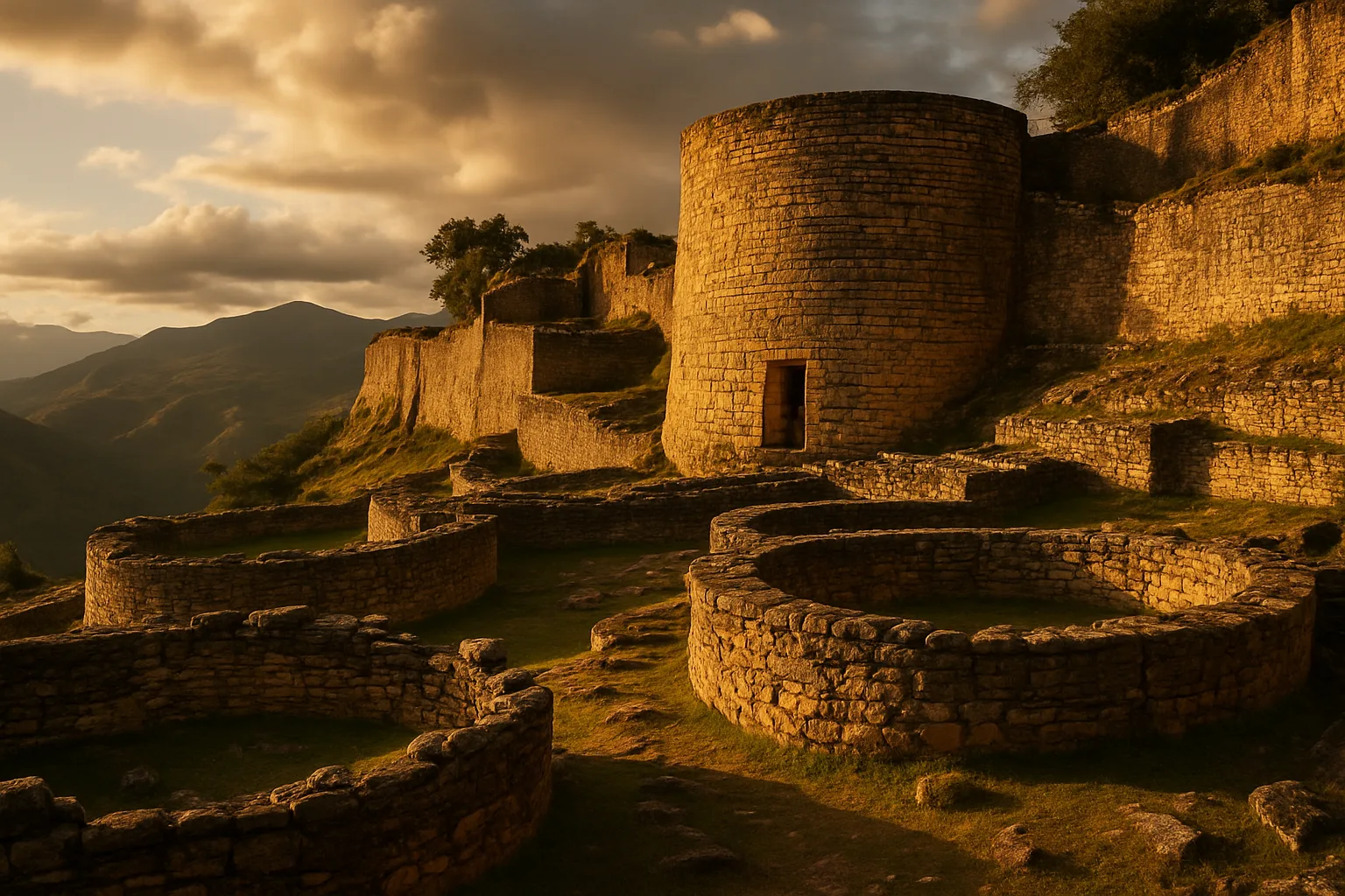
Kuelap Peru Guide 2026: Chachapoyas Cloud Fortress
ChachapoyasExplore Kuelap, the massive Chachapoyas cloud fortress in northern Peru. Reach it by cable car from ...
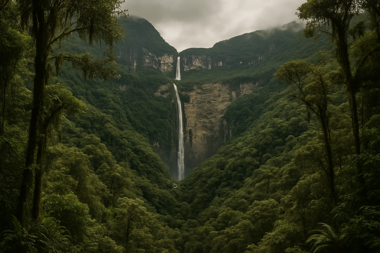
Gocta Falls Peru Guide 2026: Cloud Forest Hike & Access
Chachapoya-IncaVisit Gocta Falls in Amazonas, Peru: one of the world's tallest waterfalls with cloud-forest trails,...
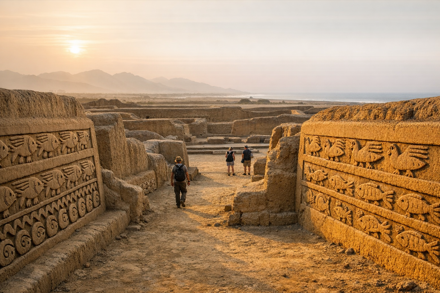
Chan Chan Peru Guide 2026: Chimu Capital & Adobe Citadels
ChimuExplore Chan Chan near Trujillo — the largest pre-Columbian city in the Americas. Discover the Chimu...