Quick Info
Curated Experiences
Relaxing Boat Trip to Phaselis Bay from Kemer
Kemer Boat Trip with Phaselis Bay Stop
Private Antalya Coast Tour: Phaselis, Chimera, and Cable Car
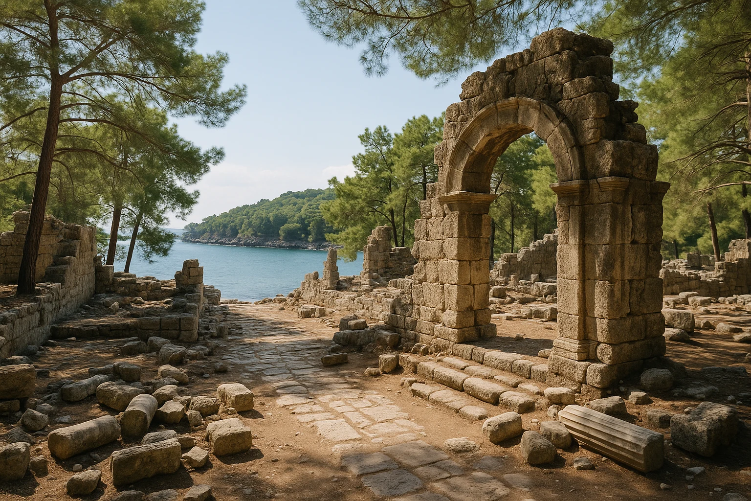
Where the Taurus Mountains fall into the Mediterranean, Phaselis, Turkey sits on a narrow forested peninsula that feels designed for sailors and storytellers. Pines lean toward three natural harbors. Roman paving stones run through the shade toward open coves of clear, blue water. You can stand beside an ancient quay, turn your head, and see both ship-borne commerce and modern beach towels occupying the same shoreline. Few archaeological sites in the eastern Mediterranean combine this much maritime history with this much physical beauty in such a compact walk.
Phaselis was never the largest city on the coast, but it was one of the most strategically gifted. Founded as a port town, absorbed into larger empires, rebuilt after raids, and eventually quieted by changing trade routes, it preserves a long record of how coastal cities survive by adapting. At Ancient Travels, we recommend Phaselis as one of the best anchors for a wider Antalya-region itinerary, especially if you want history without giving up sea time. This guide covers the historical timeline, what to see on site, transport from Antalya and Kemer, admission realities, seasonal timing, and how to combine Phaselis with nearby ruins in a single rewarding day.
History: A Port City Between Empires
Lycian and Greek foundation (c. 7th century BCE–4th century BCE)
Most classical sources describe Phaselis as a Greek-founded port on the borderland between Lycia and Pamphylia, likely established by settlers from Rhodes around the 7th century BCE. Whether that foundation story is perfectly literal or partially mythologized, archaeology confirms early urban planning centered on maritime trade. Phaselis was positioned to mediate shipping between the Aegean world, Cyprus, and Levantine routes, and its three harbors gave it unusual resilience against changing winds and naval pressures. The city minted coins, developed defensive works, and became known less for inland agriculture than for what passed through its quays.
Persian and Hellenistic transitions (4th century BCE–1st century BCE)
Like much of southern Anatolia, Phaselis moved through the power shifts triggered by Achaemenid Persian influence and then Alexander’s campaigns. The city reportedly welcomed Alexander the Great in 333 BCE, a common strategic choice for ports seeking favorable terms under new rulers. In the Hellenistic era, control shifted among successor kingdoms, and piracy became a recurring regional problem. Phaselis prospered when sea lanes were secure and suffered when they were not. Even so, its urban core retained a distinctly Hellenic civic pattern: processional street axis, public structures near the harbor approaches, and religious architecture integrated into commercial space.
Roman consolidation and urban buildout (1st century BCE–4th century CE)
Roman suppression of Cilician piracy in the 1st century BCE changed the city’s trajectory. Under Roman rule, maritime commerce stabilized, and Phaselis entered a major construction phase. The broad paved avenue most visitors walk today largely reflects this era, with drainage channels, public bath complexes, and market-adjacent structures designed for heavy daily movement. The small theater on the hillside and expanded harbor infrastructure also belong to this Romanized urban vision. Phaselis never eclipsed giant provincial centers, but it developed into a reliable mid-coast hub where ships, merchants, officials, and pilgrims could all land with predictable facilities.
Byzantine continuity and decline (5th century CE–13th century CE)
In Late Antiquity, Phaselis continued as a Byzantine coastal settlement with ecclesiastical presence and reduced but persistent maritime activity. Earthquakes, Arab naval pressures, and shifting trade currents gradually weakened the city. Silting and coastal geomorphology likely affected harbor utility over time, while inland political centers became comparatively more important. By the Seljuk period, Phaselis had largely lost its former status. Stone was reused elsewhere, vegetation reclaimed public spaces, and the peninsula shifted from living port to layered ruin.
Modern archaeology and preservation (19th century CE–present)
European travelers described Phaselis in the 19th century, but systematic archaeological work accelerated in the 20th and 21st centuries under Turkish institutions. Excavations clarified street alignments, bath structures, and harbor-zone functions while balancing research with tourism pressure from Antalya’s booming coast. Today, Phaselis is managed as both a cultural heritage landscape and a popular recreational destination. That dual identity can be messy, but it also keeps the site alive in public memory: not a fenced relic, but a place where history, forest, and sea still meet in daily use.
The Key Monuments: What to See at Phaselis
The North Harbor and quay edge
The North Harbor is usually the clearest first encounter with ancient Phaselis as a port city. Its protected basin and surviving shoreline masonry explain immediately why the founders chose this peninsula. You can still trace parts of quay alignments where cargo handling would have happened, with small inlets that offered practical shelter from weather. The harbor is not monumental in the way of giant imperial ports, but that is exactly its value: it reads as a working commercial environment scaled to regional traffic. Photography tip: in early morning, the low sun defines submerged stone lines through the water and makes harbor geometry visible even from ground level.
The Roman main street (cardo-like axis)
Running inland from the harbor zone, the main paved street is the spine of the site and one of the best-preserved urban elements in Phaselis. The stone paving blocks are broad, uneven from centuries of use, and edged by drainage channels that still demonstrate Roman attention to stormwater in coastal settlements. As you walk, you pass foundations of shops, public rooms, and civic spaces that once opened directly onto this route. It was infrastructure before aesthetics: a circulation and trade corridor connecting sea arrivals to markets and administrative points. Photography tip: use the street’s perspective lines with pine canopy overhead for your strongest “city in forest” composition.
The theater on the slope
The theater of Phaselis is modest in scale compared with Aspendos, yet it reveals how even medium-size port towns adopted standard Greco-Roman civic forms. Built into the natural slope, it likely served performances, assemblies, and public announcements tied to civic life. Surviving cavea seating and stage-zone remains are fragmentary but legible enough to understand orientation and acoustics. What makes this theater memorable is context: from certain angles, you glimpse sea and trees beyond stone seating, a reminder that entertainment architecture here was never separated from maritime landscape. Visit late morning or late afternoon for softer contrast on the worn seating rows.
Aqueduct and water management remains
Water systems were the difference between seasonal anchorage and durable city. The aqueduct remains at Phaselis, together with cistern and channel evidence, show deliberate hydraulic planning in a place with summer dryness and variable demand from visiting ships. You can read sections of elevated conduit and masonry channels feeding distribution points closer to the urban core. These are not decorative ruins; they represent logistical intelligence. Any port expecting merchants, crews, and local residents needed reliable supply, and Phaselis invested accordingly. Photography tip: shoot aqueduct fragments with tree trunks in frame to emphasize the dialogue between engineered line and natural growth.
South Harbor and beach-edge ruins
The South Harbor area is where archaeology and leisure are most visibly intertwined. Foundations and wall lines sit close to pebbled beach zones now used by day visitors, and this juxtaposition can initially feel surprising. Historically, it makes sense: sheltered coves were both economic assets and social spaces. The harbor likely handled smaller craft and local movement while supporting broader commercial rhythms. Today, this is the easiest place to understand Phaselis as a lived coastal city rather than an isolated monument complex. Come near sunset for warm light across the water and silhouettes of ruined walls against the bay.
Getting There: Transportation and Access
Phaselis is straightforward to reach if you plan your transport before leaving Antalya’s urban core.
From Antalya city center
The drive from central Antalya to the Phaselis turnoff typically takes about 1 hour to 1 hour 20 minutes, depending on season and traffic along the D400 coastal highway.
- Taxi or ride-hail: Usually 1,200-1,800 TRY ($36-55 USD) one-way depending on pickup point and time; fastest direct option.
- Public bus + short taxi: Antalya to Kemer/Tekirova corridor buses are frequent and cheaper, often 90-160 TRY ($3-5 USD) per person, then a short taxi transfer to the gate (roughly 200-350 TRY / $6-11 USD).
- Rental car: Flexible and often best value for couples or families; parking is available near the entry zone, and combining multiple sites becomes much easier.
From Kemer and Tekirova
From Kemer, Phaselis is close enough for a quick half-day outing, usually 20-30 minutes by road. From Tekirova, the ride is even shorter.
- Taxi: Commonly 300-700 TRY ($9-21 USD) depending on distance and negotiation.
- Dolmuş/minibus corridors: Budget-friendly for the main road route, but you may still need a brief taxi hop from the highway stop.
- Boat excursions: Seasonal boat tours often stop in Phaselis Bay; useful if you want scenery and swimming, though less ideal for in-depth archaeological pacing.
From Antalya Airport (AYT)
If you land and go directly to the site, travel time is usually 1 hour 15 minutes to 1 hour 40 minutes.
- Airport taxi/private transfer: Approximately 1,700-2,500 TRY ($52-76 USD), with direct drop-off.
- Car rental from airport: Practical for multi-day Antalya coast itineraries.
- Tour operator pickup: Good no-stress option when booked with a day trip including Phaselis.
Practical Information
Admission and hours
Phaselis typically opens in the morning and closes near sunset, with seasonal shifts in exact times. International visitor pricing is often posted in euros (commonly around €10, roughly 350 TRY / $11 USD at recent exchange levels), while domestic card programs may have different terms. Because Turkish archaeological pricing can update without much notice, check official culture portal listings or your ticket app the day before travel.
Bring both a card and some cash. Card acceptance has improved, but backup cash avoids delays at busy entry windows. The best visit window is usually early morning for cooler temperatures and quiet paths, or late afternoon for softer light and fewer tour-bus peaks. Midday in summer can be punishingly hot, especially on exposed stone segments between shaded pines.
What to bring
- Sun protection: Hat, sunscreen, and light long sleeves for exposed sections.
- Water: At least 1 liter per person, more in summer.
- Footwear: Grippy sandals or walking shoes for uneven paving and pebbled edges.
- Swim gear: Optional but useful if you plan to use the coves after exploring ruins.
- Offline map: Handy where mobile signal fluctuates under forest cover.
When to Visit: Seasonal Considerations
Spring (March-May)
Spring is the strongest all-around season for Phaselis, with temperatures commonly around 17-27°C (63-81°F). The forest is fresh, visibility is usually clear, and walking the full urban axis is comfortable. Crowd levels rise during school holidays, but early arrival still buys quiet. If you want both archaeology and a short swim, late spring is especially good.
Summer (June-August)
Summer brings heat, often 30-36°C (86-97°F) by midday, with high UV and reflective glare off stone and sea. Crowds are highest, especially from coastal resorts and boat trips. Visit at opening time, rest in shaded pine zones between monuments, and avoid long exposed stops around noon. For most travelers, summer is manageable only with deliberate pacing.
Autumn (September-November)
Autumn is nearly as good as spring, with sea still warm and air temperatures typically 20-31°C (68-88°F) in early autumn, cooling later in the season. Crowds thin after peak holiday periods, and late-afternoon light is excellent for harbor photography. This is an ideal shoulder season if you prefer space without sacrificing beach conditions.
Winter (December-February)
Winter is quiet and atmospheric, generally 10-18°C (50-64°F), though rain and wind can appear quickly. The site becomes greener, and you may have long stretches of path to yourself. If weather is stable, winter can be wonderful for focused historical exploration, but bring a light waterproof layer and check same-day conditions before departing Antalya.
Combining Phaselis with the Antalya Coast
Phaselis works best as a flexible half-day anchor that can be expanded into a full coastal circuit depending on your energy and interests.
A rewarding sequence starts with arrival at 8:30 AM, before day-trip buses settle in. Spend your first hour on the North Harbor and main street while temperatures are low and shadows still give depth to architectural lines. By 10:00 AM, move upslope to the theater and water-system remains, then loop back through the pine corridor toward the South Harbor for a final archaeological pass. If you want beach time, reserve 11:30 AM to 12:15 PM for a short swim and reset before leaving.
From there, continue by car toward Olympos and Çıralı, arriving around 1:00 PM for lunch near the riverfront or beach approach roads. In the late afternoon, head to Yanartaş (the Chimaera flames) for a hike timed around sunset, when the natural gas flames are most dramatic against dusk. This full arc takes roughly 10 to 11 hours with transfers.
If you prefer a shorter day, pair Phaselis with central Kemer only. Visit ruins in the morning, then have a long seaside lunch around 1:30 PM at Kemer Marina, returning to Antalya before evening traffic peaks. That version is about 6 hours total and still gives a complete sense of the coast’s historical and contemporary rhythm.
Why Phaselis Matters
Phaselis matters because it shows ancient urban life at human scale, without losing historical depth. This was not an imperial capital designed to overwhelm. It was a working port where commerce, infrastructure, religion, and daily routines had to coexist under changing rulers for centuries. You can still read that pragmatism in the paving, drainage, harbor walls, and water channels.
It also matters because the setting rewrites how many travelers imagine ruins. At Phaselis, antiquity is not isolated from landscape. Stone sits under pine needles. Theater steps face open sky and sea wind. Harbor masonry disappears into clear water where people still swim. The effect is less museum, more continuity.
If your journey through Turkey is about understanding how geography shapes civilization, Phaselis is essential. Come early, walk slowly, and let the site reveal itself harbor by harbor.
Quick Facts
| Attribute | Details |
|---|---|
| Location | Phaselis peninsula, near Tekirova (Antalya Province), Turkey |
| Ancient Name | Phaselis |
| UNESCO Status | Not inscribed as a standalone UNESCO World Heritage Site |
| Established | c. 7th century BCE port foundation |
| Distance from nearest hub | ~16 km from Kemer (about 25 minutes by car) |
| Entry Fee | Commonly around €10 (approx. 350 TRY / $11 USD), subject to updates |
| Hours | Seasonal; generally morning to near sunset |
| Best Time | Spring and autumn; early morning or late afternoon |
| Suggested Stay | 2-3 hours (4+ with swimming) |
| Known For | Three harbors, Roman street axis, aqueduct, and pine-forest coastal setting |
Explore More Turkey
- Perge: A major Pamphylian city with grand colonnaded streets and stadium remains near Antalya.
- Aspendos: Home to one of the best-preserved Roman theaters anywhere in the Mediterranean.
- Myra: Lycian rock-cut tombs and a large Roman theater in Demre.
Plan a broader southern route with our Turkey ancient sites hub and sharpen logistics with our Turkey transportation guides.
Frequently Asked Questions
How much time should I plan at Phaselis?
Most travelers need 2 to 3 hours for the main street, theater, aqueduct, and harbor walks. If you want time for swimming at one of the coves, plan 4 to 5 hours. The site is compact but rewarding when explored slowly.
What is the best time to visit Phaselis?
Spring and autumn are ideal, with warm but manageable temperatures and softer light for photos. In summer, arrive early (before 9:00 AM) to avoid midday heat and busier beach crowds. Winter is quieter and green, though occasional rain can make paths slippery.
How much does Phaselis cost, and is it included in museum cards?
Entry is typically priced in euros for international visitors (commonly around €10, with TRY payment accepted at current exchange rates). Türkiye's MüzeKart options can apply for eligible visitors and residents. Check official Ministry of Culture updates before your visit, as prices change seasonally.
How do I get to Phaselis from Antalya?
From Antalya, the easiest route is by car or taxi via the D400 toward Kemer, then the signed turnoff to Phaselis. Public buses heading to Tekirova or Kemer can get you close, followed by a short taxi ride. Organized day tours are the simplest no-planning option if you want transport and guiding included.
What are the top highlights inside Phaselis?
The standouts are the North Harbor, the broad Roman-era main street with drainage channels, the theater on the slope, and sections of the aqueduct feeding the old city. The pine forest setting and sea views make the ruins feel unusually calm compared with inland sites.
Is Phaselis suitable for families and casual visitors?
Yes. Paths are generally easy around the core ruins, and nearby beaches make it attractive for mixed-interest groups. Bring water, sun protection, and sturdy sandals or shoes for uneven stone surfaces.
Nearby Ancient Sites
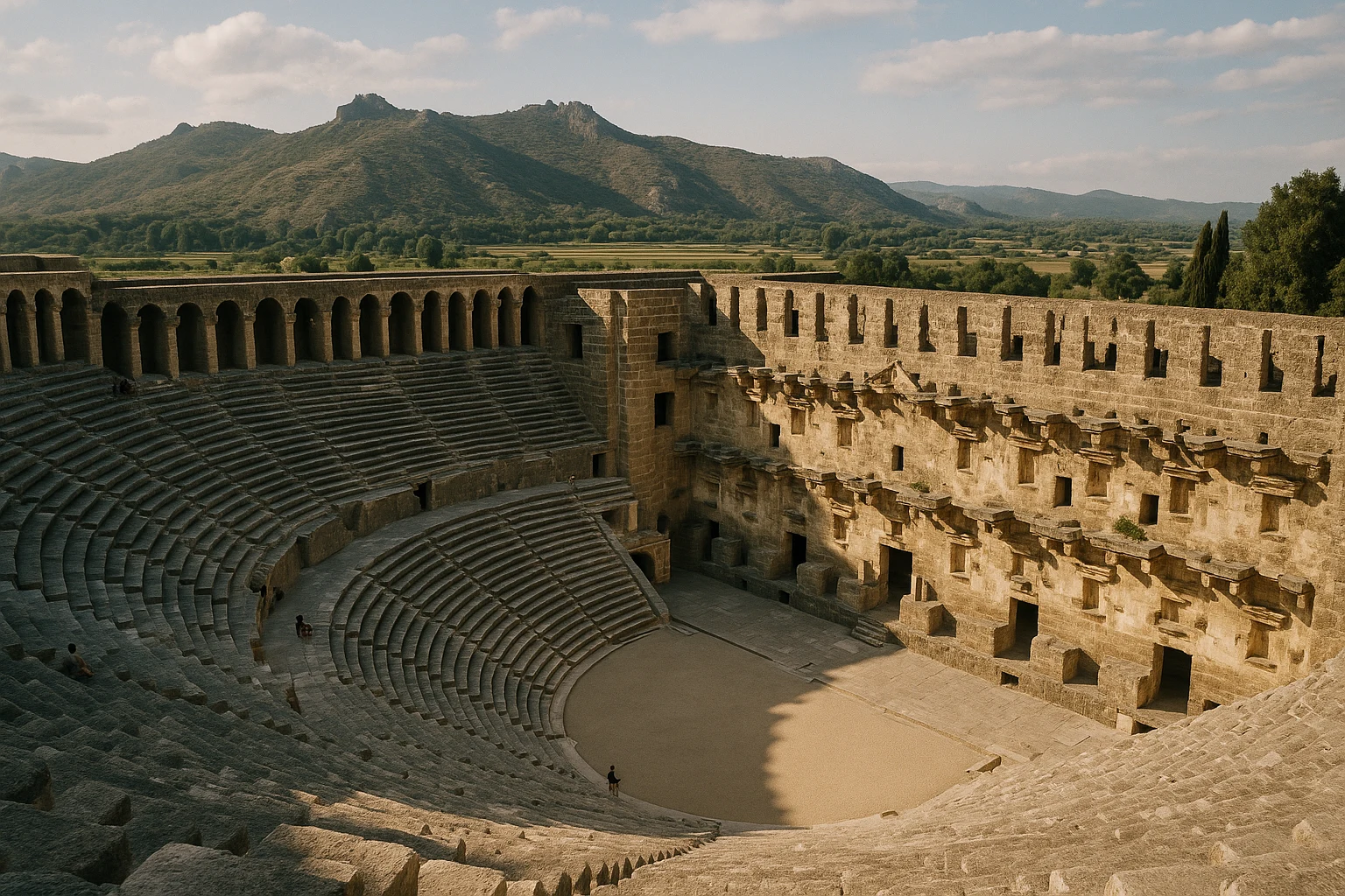
Aspendos Turkey Guide 2026: Roman Theatre & Pamphylian Aqueduct
Pamphylian-Greek-Roman-Byzantine-SeljukPlan your Aspendos visit in Turkey with practical tips on tickets, transport from Antalya, and what ...
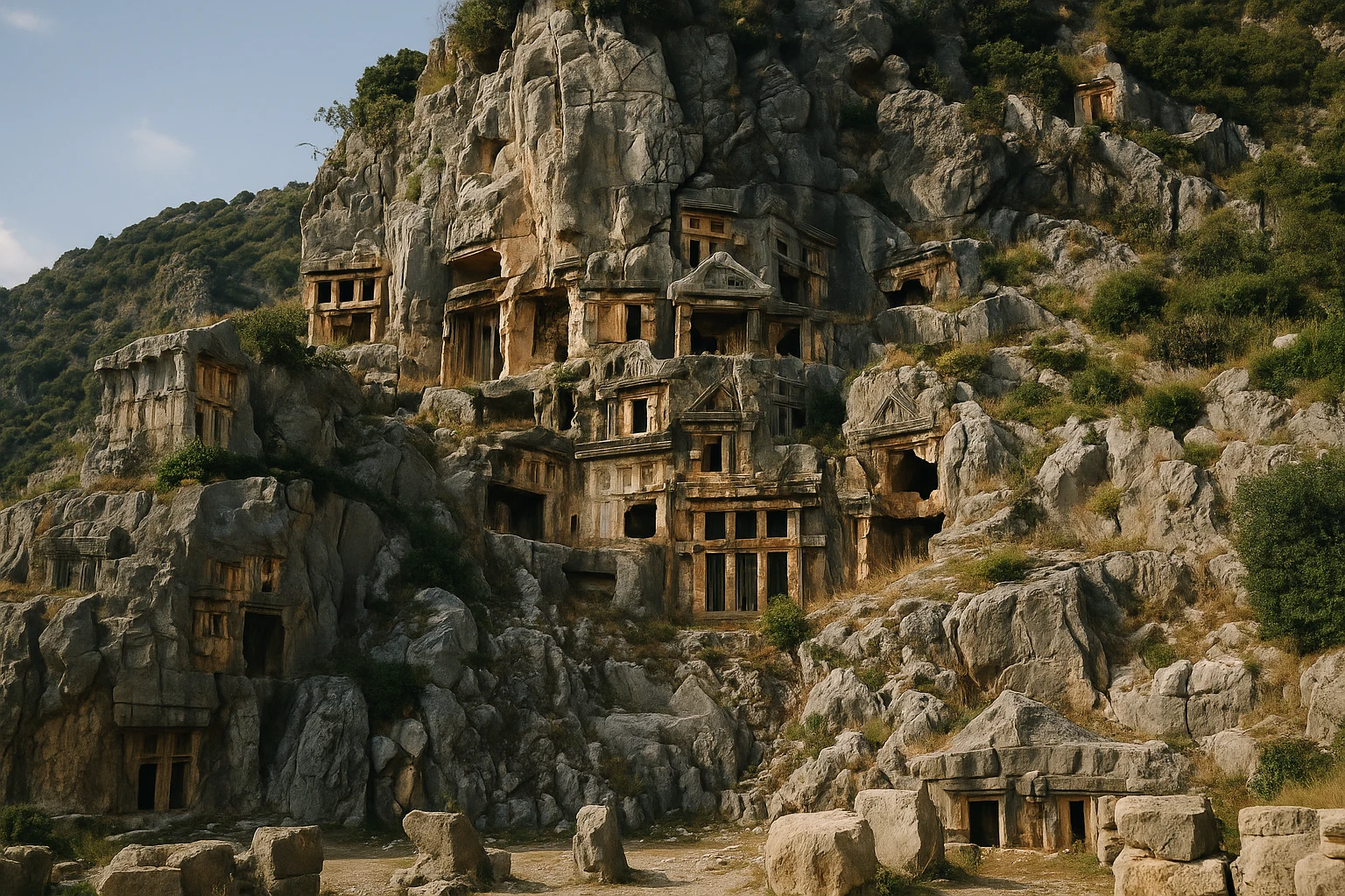
Myra Turkey Guide 2026: Lycian Tombs & Roman Theatre
Lycian-Roman-ByzantinePlan your Myra, Turkey visit with rock-cut Lycian tombs, a Roman theatre, tickets, hours, and transp...