
Quick Info
Curated Experiences
4-Day Choquequirao Trek Includes Services From Cusco
Choquequirao Trek to Machu Picchu 8 Days
Private Choquequirao Trek Adventure from Cusco
The first thing Choquequirao does is silence you. Not because there are crowds to navigate or whistles from guides with colored flags, but because there are so few people at all. After hours of switchbacks above the Apurímac River, the ridge opens, clouds shift, and stone terraces appear in the distance as if they were being revealed rather than discovered. This Choquequirao Peru travel guide begins where every real visit begins: with effort. You do not arrive here by train or bus. You earn your way in on foot, and that physical approach changes how you read the site when you finally stand inside it.
Set high above one of the deepest canyons in the Andes, Choquequirao is often called Machu Picchu’s sister city, but that label undersells it. The complex is vast, partially excavated, and still wrapped in cloud-forest vegetation that makes every uncovered wall feel like an active archaeological event. At Ancient Travels, we recommend Choquequirao for travelers who want the Inca world at a slower, more intimate scale: fewer visitors, longer conversations with landscape, and monuments that feel like they are still stepping out of the mountain. This guide covers the site’s history, the major architectural sectors, trek access from Cusco, practical planning, seasonal strategy, and how to combine Choquequirao with Peru’s Sacred Valley highlights.
History: A mountaintop city between empire and frontier
Before Inca expansion: regional highland cultures (c. 1000-1400 CE)
Long before imperial Inca masonry spread across the Vilcabamba ranges, these slopes were used by highland societies connected to what archaeologists broadly classify as Late Intermediate Period cultures, including groups often associated with the Killke tradition around Cusco. The ridge where Choquequirao stands offered strategic views over movement corridors linking high puna routes with lower tropical valleys. Even if the monumental city we see today is Inca in form, the location itself was chosen within an older Andean geography of lookout points, ritual mountains, and controlled agricultural pockets. In other words, the Inca did not invent the significance of this place; they intensified it.
Imperial construction under the Inca state (15th century CE)
Most evidence places Choquequirao’s major construction in the 15th century during the height of the Inca Empire, likely under rulers in the Pachacuti-to-Tupac Inca Yupanqui era when state architecture expanded aggressively across the Andes. The city’s urban plan follows classic imperial logic: ceremonial spaces on high ground, residential compounds grouped by function and status, and agricultural terraces cut into severe slopes to stabilize soil while producing maize and other crops. Fine stonework appears in important ritual sectors, while utilitarian retaining walls show practical engineering priorities. Choquequirao was not a random refuge; it was a planned administrative and ceremonial node embedded in imperial strategy.
Civil war, Spanish invasion, and the Vilcabamba resistance (16th century CE)
The 16th century brought cascading upheaval. The Inca civil war between Atahualpa and Huáscar fractured political unity just as Spanish forces entered the region. In the years that followed, surviving Inca elites regrouped in the Vilcabamba zone, using remote mountain networks to resist colonial control. Choquequirao’s position in this broader landscape likely made it part of logistical and symbolic circuits connected to that resistance world, even if it was not the principal capital itself. Like many Andean sites, it appears to have experienced gradual abandonment rather than a single dramatic “fall,” with paths and terraces continuing to serve local needs after elite functions declined.
Colonial memory and local knowledge (17th-19th centuries)
Spanish colonial documents mention difficult mountain routes and old Inca constructions in the broader region, but Choquequirao did not enter global travel imagination in the way Machu Picchu eventually would. Local communities, however, retained practical knowledge of trails, ruins, and place names. This gap between local continuity and outside “discovery” is crucial: the site was never truly lost to everyone, only to external scholarly and tourist systems. Throughout the colonial and republican periods, vegetation reclaimed many architectural sectors, preserving some walls while hiding others under dense growth.
Modern archaeology and ongoing excavation (20th century-present)
Systematic study accelerated in the 20th century, with Peruvian archaeologists and conservation teams mapping, excavating, and stabilizing key zones across a site that still has major unexcavated portions. One of the most celebrated findings is the terrace complex with white quartzite llama figures inlaid into darker stone, a visual signature unlike anything at comparable Inca centers. Today Choquequirao remains both a destination and an active research landscape. That matters for travelers: you are not walking through a finished museum, but through a living archaeological process where each season can reveal new walls, pathways, and interpretations.
The Key Monuments: What to See at Choquequirao
Main plaza and ceremonial core
The heart of Choquequirao is a sequence of open spaces and platforms that functioned as the ceremonial and administrative center. From the main plaza, you can trace sightlines toward surrounding ridges, a reminder that Inca urbanism was never separate from mountain cosmology. Buildings around the plaza include kallanka-style halls and elite compounds with tighter stone joints than peripheral sectors, suggesting differentiated status and use. The layout allows controlled gatherings while preserving processional movement between sacred and civic zones. Early morning is ideal here: low light brings out the relief in masonry courses and you can read how walls were keyed into bedrock instead of simply resting on it.
The usnu and ritual architecture
Many researchers identify elevated ceremonial platforms in Choquequirao as usnu-type ritual spaces, where offerings, observation, and political theater could overlap. These structures are modest compared with imperial capitals but strategically placed to command both plaza visibility and mountain horizons. The Inca state performed power through choreography as much as force, and architecture like this provided stages for that choreography. Pay attention to orientation: openings and platform edges often frame specific peaks or valley lines, reinforcing the idea that ritual action here was tied to a sacred landscape map. For photography, late afternoon can produce dramatic shadows across stepped stone edges.
Agricultural terraces and hydraulic intelligence
Choquequirao’s terraces are not decorative leftovers; they are core infrastructure. Cut deeply into steep slopes, these retaining systems controlled erosion, created microclimates, and expanded usable agricultural land in a topography that seems almost impossible for farming. Drainage channels and layered fill demonstrate advanced engineering that balanced water retention with runoff control during heavy Andean rains. Walking these sectors makes clear that food security and slope stabilization were as monumental as temples. If you want to understand Inca state capacity, spend time here, not just in plazas. Mid-morning gives the best visibility across terrace geometry before clouds thicken.
The white llama terraces
This is Choquequirao’s most distinctive feature: a series of terrace walls with white quartzite llama figures set into darker stone. The llamas appear in profile, moving in procession across the hillside like a frozen herd. Scholars debate exact meaning, but most interpretations connect them to camelid wealth, caravan movement, and highland ritual economy. Their placement on working agricultural architecture is especially striking, blending symbolic expression with practical infrastructure rather than separating art into elite enclosures. The sector requires extra walking on sloped paths, but it is non-negotiable if you came this far. Bring a lens with moderate zoom; details read better from across the opposing terraces.
Residential compounds and daily life spaces
Beyond the ceremonial core, clusters of rectangular structures and enclosed patios suggest housing for administrators, specialists, retainers, and support labor. Storage features in some compounds indicate redistribution functions typical of imperial centers, where goods moved in and out through state-managed networks. You can also see construction variation here: some walls are rougher, quickly built, or repaired, which hints at changing occupation phases and practical adaptation over time. This is where Choquequirao feels most human. Not a postcard icon, but a lived place where cooking, sleeping, storing, and planning happened under the same mountain weather you feel today.
Viewpoints over the Apurímac canyon
Choquequirao’s setting is itself a monument. From several exposed edges near the upper sectors, the Apurímac canyon drops away in massive folds, and condors are occasionally visible riding thermals. These lookouts explain the site’s dual character as sanctuary and strategic overlook. They also remind you why reaching the site is physically demanding: every dramatic view corresponds to equally dramatic terrain underfoot. Clouds move fast here, so if visibility opens, take your panoramic shots immediately. The best light usually comes early and late, with midday often flattening depth in the canyon.
Getting There: Transportation and Access
Reaching Choquequirao is a trek-first experience: road transport gets you to trailheads, but the ruins require sustained hiking through steep canyon terrain.
From Cusco to Cachora or Capuliyoc
Most visitors start in Cusco and transfer by road to Cachora or directly to Capuliyoc, the common trek departure point. Travel time is usually 4-5 hours depending on road conditions and stops.
- Private transfer: Door-to-door vehicle from Cusco, typically 450-750 PEN ($120-200 USD) one way depending on group size and season.
- Shared transport + local taxi: Combined vans/buses plus short onward transfer, often 80-180 PEN ($22-48 USD) per person total, but schedules can be fragmented.
- Tour operator transport: Included in guided packages; usually the smoothest option for first-time trekkers because timing aligns with camp and mule logistics.
Trail approach and trekking options
From Capuliyoc, most itineraries descend toward the Apurímac, cross near Playa Rosalina, then climb to Marampata and onward to the site sectors. Round-trip routes commonly run 4 days, with slower or extended variants at 5 days.
- Guided trek: Includes guide, muleteers, camps, and meals; often 1,900-4,500 PEN ($510-1,210 USD) depending on service level.
- Independent trekking: Lower direct costs but requires managing food, tents, navigation, and contingency planning for weather and injuries.
- Mule support add-on: Available through local arranges near trail communities, helpful for water, camping gear, and safer pacing on climbs.
Admission and hours
Choquequirao entry is paid in cash in Peruvian soles at control points, with rates that may vary by traveler category and administrative updates. As a practical planning range, many trekkers budget roughly 60-70 PEN ($16-19 USD) for foreign adult entry, but always confirm current official pricing before departure. Site access hours are generally daytime-oriented due to trekking safety and ranger control, and most groups visit early morning through mid-afternoon. Card payment is typically unavailable on route, so carry extra soles for fees, camps, and small purchases. The most comfortable visit window on-site is early morning, when visibility is often cleaner and heat on exposed stairs is lower.
When to Visit: Seasonal Considerations
Spring shoulder (September-November)
Temperatures often sit around 10-24°C (50-75°F), with warming days and variable early rains as the wet season approaches. Trails are usually manageable in September and October, while November can become muddier. Crowds remain moderate compared with peak dry-season months. This period can deliver dramatic green slopes and good photography conditions when clouds break after brief showers.
Summer rains (December-February)
Expect frequent precipitation, humidity, and slick trail sections, with many trekking segments around 12-23°C (54-73°F) but feeling warmer in sun breaks. Crowd levels are lower, which appeals to experienced hikers seeking solitude. The tradeoff is route unpredictability: landslides, swollen streams, and slower pace can affect schedules. Waterproof layers, trekking poles, and flexible timing are essential.
Autumn transition (March-May)
Late wet-season conditions gradually clear, and by April-May many trekkers find a strong balance of greener landscapes and improving trail reliability. Typical ranges run 11-24°C (52-75°F), with cool nights at camp. Crowd levels rise into May as dry-season planning begins, but the route still feels uncrowded versus Peru’s marquee circuits. For many travelers, this is the ideal compromise season.
Winter dry season (June-August)
This is the classic trekking window, with the most stable skies and daytime temperatures often around 9-22°C (48-72°F), while nights can drop sharply at higher camps. Visibility is usually excellent for canyon and ridge views, and route confidence is highest. Crowd levels are the year’s peak for Choquequirao, though still relatively light compared with Machu Picchu access routes. If you prioritize reliable weather and clean mountain light, winter dry season is the strongest choice.
Combining Choquequirao with Cusco and the Sacred Valley
Choquequirao works best as the anchor of a longer Cusco-region itinerary rather than a standalone box-checking trek. The most effective sequence is to acclimatize in Cusco first, spending at least two nights before departure so the canyon descent and climb are less punishing. On trek day one, most travelers leave by 4:30-5:30 AM, reach Capuliyoc by late morning, and begin descending while temperatures are still manageable. By late afternoon, camps near Chiquisca or Santa Rosa set up a rhythm that balances effort and recovery.
A classic four-day plan reaches the archaeological sectors around early morning on day two or three depending on camp choice. This timing matters: first light over the terraces gives both better visibility and a calmer, almost private experience across the ceremonial core. After a full site exploration, many itineraries overnight at Marampata to avoid rushing the return ascent from river level. You are usually back near road access by midday on day four, then in Cusco by evening.
If you have extra time, continue into the Sacred Valley after a recovery day. Start Ollantaytambo around 8:00 AM for fortress sectors before midday heat, then pair Pisac the following morning for market-town context and broad terrace views. This creates a rewarding narrative arc: Choquequirao’s remote imperial frontier first, then the valley’s better-known administrative and agricultural centers. In total, plan 7-9 days for a coherent Cusco + Choquequirao + Sacred Valley journey without turning the whole trip into a sprint.
Why Choquequirao Matters
Choquequirao matters because it restores scale to the Inca story. At famous sites, you often inherit a finished narrative: where to stand, what to photograph, what each wall means. Here, the narrative is still being assembled. You feel the empire not as a polished icon, but as labor, engineering, ritual, weather, and distance. Terraces hold mountains in place. Stone paths negotiate impossible gradients. White llama figures move across retaining walls like memory embedded in infrastructure.
It also matters because access filters intention. People who come here usually come to listen as much as to see. That creates a different atmosphere: quieter camps, slower conversations, more attention to terrain and history rather than checklists. In a travel era built on acceleration, Choquequirao insists on sequence, effort, and patience. If Machu Picchu is the Inca world presented, Choquequirao is the Inca world still unfolding.
Quick Facts
| Attribute | Details |
|---|---|
| Location | Vilcabamba range, Cusco Region, Peru |
| Ancient Name | Choqek’iraw (commonly rendered Choquequirao) |
| UNESCO Status | Not independently inscribed; part of the wider Inca cultural landscape under study |
| Established | c. 15th century CE royal-administrative center |
| Distance from Cusco | ~155 km by road to trailhead + multi-day trek |
| Entry Fee | Commonly around 60-70 PEN ($16-19 USD), cash in soles |
| Typical Access Window | Daytime site visits within multi-day trekking itineraries |
| Best Time | April-August, with May-August for the driest conditions |
| Suggested Stay | 4-5 days round-trip trek from Cusco |
| Primary Highlight | White quartzite llama relief terraces |
Explore More Peru
- Machu Picchu: Peru’s iconic Inca citadel, best paired after acclimatization and advance ticket planning.
- Ollantaytambo: Fortress-temple complex and living Inca street grid in the Sacred Valley.
- Pisac: Terraces, ritual sectors, and one of the valley’s most dramatic ridge settings.
- Huayna Picchu: Steep summit climb above Machu Picchu for travelers wanting a high-view extension.
Plan your full Andean route with our Peru Ancient Sites Guide. If you’re building a Cusco-first itinerary, start with our practical Sacred Valley planning guide.
Frequently Asked Questions
How difficult is the Choquequirao trek?
This is a strenuous mountain route with long descents and climbs, typically 4-5 days round-trip. Most travelers cover 58-64 km (36-40 mi) with major elevation changes between approximately 1,500 m and 3,100 m. Good cardiovascular preparation and trekking experience make the journey much more enjoyable.
How much time should I plan at the ruins themselves?
Plan at least a half day at Choquequirao, and ideally a full day if you want to visit multiple sectors without rushing. The complex is larger than many visitors expect, and some terraces require extra walking on steep paths. Spending the night at nearby camps allows you to explore in better morning light.
What is the best season for visiting Choquequirao?
The driest and most reliable trekking window is generally May through September, with June to August offering clearer skies but colder nights. Shoulder months (April and October) can be excellent with greener landscapes and fewer groups. Heavy rain from December to March can make trails muddy and river crossings more complicated.
How do I get to the Choquequirao trailhead from Cusco?
Most travelers drive from Cusco to Cachora or Capuliyoc, usually 4-5 hours by private vehicle or organized trek transport. Public options exist via shared vans and local buses but require more transfers and schedule flexibility. A guided package is often the simplest choice if you want logistics handled end-to-end.
What are the current entry fees and permits for Choquequirao?
Entry fees are paid in Peruvian soles at control points and can change seasonally, so confirm with official regional tourism sources or your operator before departure. There is no train access like Machu Picchu; access is by foot only. Bring cash in soles because card payment is usually unavailable on the route.
Is Choquequirao safe for independent trekkers?
Yes, many independent trekkers complete the route safely, but it requires planning for weather, water, camps, and physical effort. Solo travelers should register at checkpoints, carry navigation backups, and monitor trail conditions after rain. Hiring a guide or muleteer adds both safety and historical context.
Nearby Ancient Sites
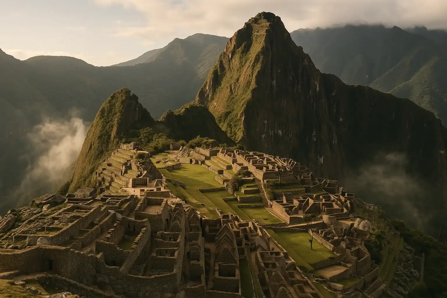
Machu Picchu Peru Travel Guide 2026: Circuits, Tickets & Entry Tips
Inca EmpireNavigate Machu Picchu's 2026 circuit system with our definitive guide. Learn how to choose your rout...
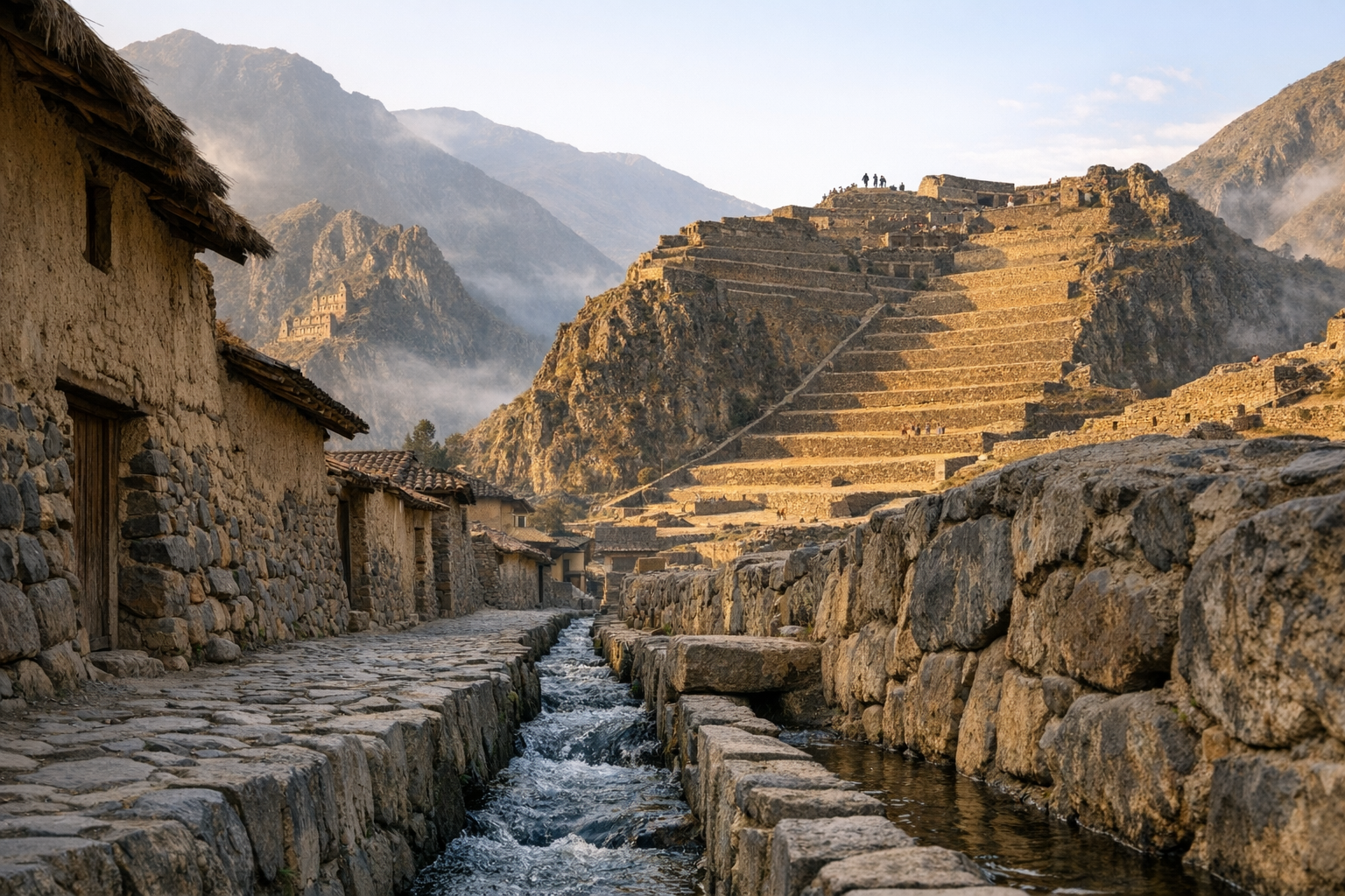
Ollantaytambo Peru Guide 2026: Inca Fortress & Sacred Valley Town
IncaVisit Ollantaytambo in Peru's Sacred Valley: explore the Inca fortress terraces, the Sun Temple, and...
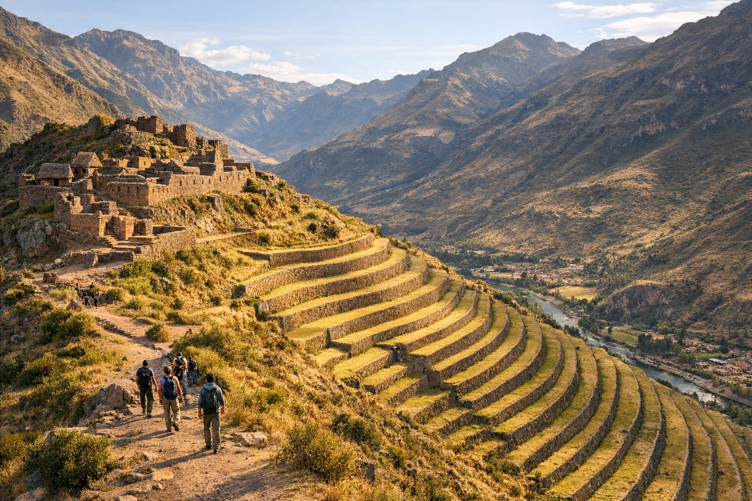
Pisac Peru Guide 2026: Inca Citadel, Market & Sacred Valley
IncaExplore Pisac in Peru's Sacred Valley: hike the Inca citadel terraces above town, visit the famous a...
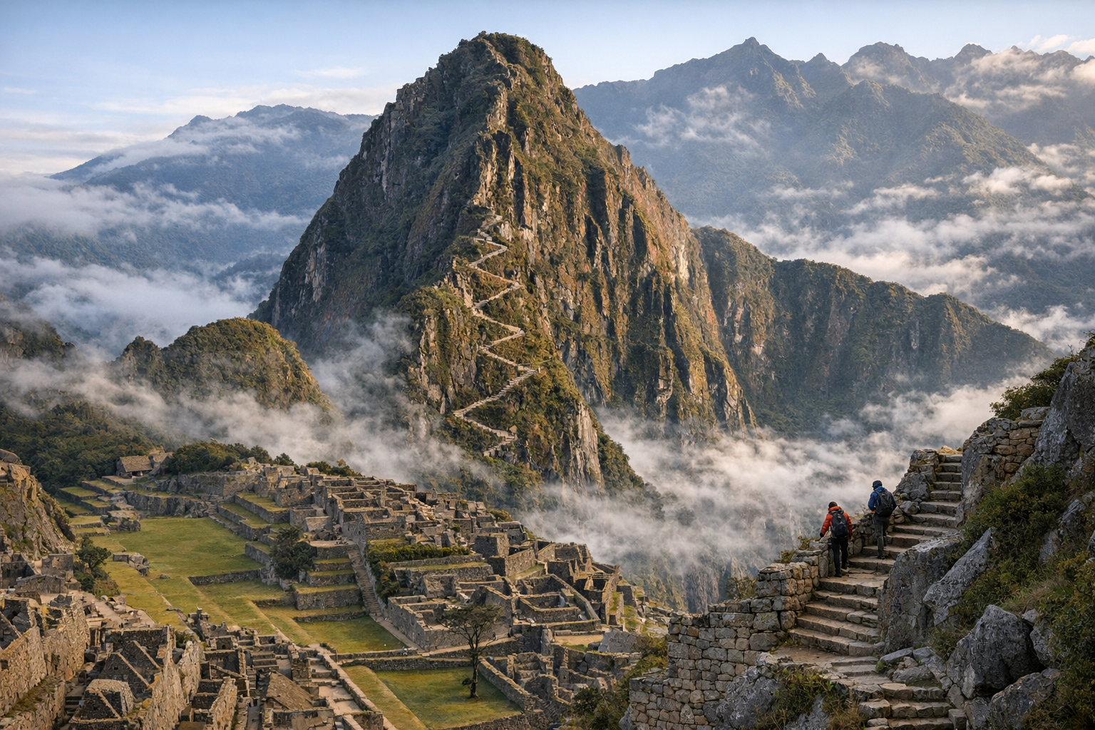
Huayna Picchu Peru Guide 2026: Hike Tickets & Summit Views
IncaClimb Huayna Picchu — the iconic peak above Machu Picchu. Essential guide to limited permits, trail ...