Quick Info
Curated Experiences
Hadrian's Wall and Roman Forts Full-Day Tour
Hadrian's Wall with Vindolanda and Housesteads
Private Hadrian's Wall Historical Day Tour
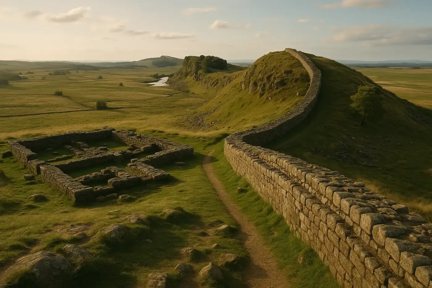
Hadrian’s Wall stretches 73 miles across northern England, from Wallsend on the River Tyne to Bowness-on-Solway on the Irish Sea coast. It is not a single monument you walk up to, photograph, and leave. It is a frontier system - forts, milecastles, turrets, ditches, military roads, and civilian settlements layered across a dramatic landscape. Planning well means choosing a focused section rather than trying to “do” the whole wall, and understanding that the strongest experiences come from combining ruins, museums, and walking.
Most visitors who feel underwhelmed made the same mistake: they drove to one spot, looked at stones, and left. The wall rewards those who slow down, walk even a short stretch, and pair what they see outside with what the museums preserve inside.
Why Hadrian’s Wall Matters
This is the most substantial surviving Roman frontier monument anywhere in the former empire. Other limites (frontier boundaries) in Germany, North Africa, and the Middle East survive in fragments, but nowhere else can you walk miles of continuous wall line through open countryside, visit multiple garrison forts, and see the physical infrastructure of Roman imperial control laid out at landscape scale.
For travelers interested in how empires actually functioned at their edges - not just how they looked at their centers - Hadrian’s Wall is unmatched. It shows the daily machinery of frontier life: where soldiers slept, how supplies moved, where civilians clustered to trade, and how Rome managed the boundary between “inside” and “outside” its world.
UNESCO inscribed the wall as part of the broader “Frontiers of the Roman Empire” World Heritage Site in 1987, linking it to frontier remains across Europe. But the English section remains the most visitable and best-interpreted stretch of that entire transnational network.
Historical Context
Emperor Hadrian ordered construction of the wall beginning in 122 CE, during a visit to Britain. The project took roughly six years to complete in its initial form, though modifications continued for decades. Unlike a simple defensive barrier, the wall functioned as a control system - regulating movement, taxation, and surveillance across the frontier rather than serving as a last-ditch fortification.
The wall incorporated a milecastle (a small fortified gateway) at every Roman mile, with two turrets spaced evenly between each pair. Larger garrison forts like Housesteads, Vindolanda, and Birdoswald housed auxiliary troops drawn from across the empire - Batavians from the Netherlands, Tungrians from Belgium, Hamians from Syria. The diversity of these garrisons is one of the wall’s most compelling historical dimensions, visible in religious dedications, personal letters, and everyday artifacts recovered from excavations.
Rome maintained the wall as an active military frontier for nearly 300 years, until the withdrawal of Roman forces from Britain in the early 5th century. After that, locals quarried its stone for churches, farmhouses, and field walls. What survives today is most impressive in the central sector, where the wall rides the natural ridge of the Whin Sill, a volcanic dolerite escarpment that gave the Romans both a defensive advantage and gave modern visitors the most photogenic stretches.
What to Prioritize Onsite
Housesteads Roman Fort (Vercovicium)
The best single-stop introduction to the wall. Housesteads sits on the ridge with commanding views north and south. The fort layout is clearly readable - barracks, granaries, headquarters building, hospital, and the famous communal latrines. Walking from the fort along the wall in either direction gives you the landscape context that photographs alone cannot convey.
Vindolanda Fort and Museum
Vindolanda predates the wall itself and has been under continuous excavation since the 1930s. Its museum holds some of the most remarkable Roman-era finds in Britain, including the Vindolanda writing tablets - thin wooden postcards preserving personal letters, military reports, and shopping lists from frontier soldiers and their families. These tablets do more to humanize Roman Britain than any standing ruin. Allow at least 90 minutes for the museum and excavation site combined.
Chesters Roman Fort (Cilurnum)
Chesters preserves the best-visible military bathhouse on the wall, along with well-defined barracks and a bridge abutment on the North Tyne. It offers a different character from Housesteads - lower elevation, river valley setting, and a strong focus on the daily hygiene and social routines of garrison life.
Sycamore Gap and the Central Ridge Walk
The central sector between Steel Rigg and Housesteads delivers the wall’s most iconic scenery. Even a 45- to 90-minute walk along this stretch transforms your understanding of the site. The terrain explains the wall’s route logic better than any museum panel. Note that the famous Sycamore Gap tree was felled in 2023, but the landscape remains dramatic and the walking is still the wall’s finest.
The Roman Army Museum and Walltown Crags
Located near Carvoran, the Roman Army Museum (run by the Vindolanda Trust) provides a strong overview of Roman military life through film and interactive displays. Walltown Crags, a short walk away, offers another excellent ridge-top wall section with fewer crowds than Housesteads.
Practical Visit Strategy
Timing. Late spring through early autumn (May to September) offers the longest daylight and the best conditions for walking. Weekday mornings outside school holidays give you the quietest experience at major sites. Weather in northern England shifts fast - wind and rain can arrive without warning even in July.
How long. A single full day is enough to visit two major sites and walk one wall segment. Two days allows a more relaxed pace and a third or fourth stop. Attempting the full 84-mile Hadrian’s Wall Path National Trail requires six to eight days.
Getting around. The AD122 seasonal bus service (typically late May through September) connects major sites along the central sector, making car-free visits feasible. With a car, drive times between stops are short individually but add up across a full day. Build buffer time rather than cramming in one more stop.
What to bring. Waterproof jacket and trousers, sturdy walking shoes with grip (the ridge sections are uneven and exposed), layers for wind, water, and a packed lunch if you plan to walk - there are limited food options between sites. Binoculars are useful for reading inscriptions and spotting landscape features.
Tickets. Housesteads and Chesters are managed by English Heritage (membership or entry fee). Vindolanda and the Roman Army Museum operate under the Vindolanda Trust with a separate combined ticket. Neither system is expensive, but check seasonal opening hours before visiting - some sites close early or entirely in winter months.
Route Pairing and Nearby Sites
Hadrian’s Wall pairs naturally with other UK heritage destinations to build a broader itinerary. The Roman Baths in Bath offer the urban, civic-religious counterpart to the wall’s military frontier. Together, they show two fundamentally different expressions of Roman power in Britain.
For a deeper timeline through British history, Stonehenge anchors the prehistoric end, while the Tower of London provides the medieval and early-modern chapter. A route connecting all four covers roughly 3,000 years of power, defense, and ritual on one island.
Closer to the wall itself, the city of Newcastle offers the Segedunum fort reconstruction at the wall’s eastern terminus in Wallsend, plus the Great North Museum’s Roman collection. Carlisle, near the western end, has Tullie House Museum with strong regional archaeology displays. Either city works as a comfortable base.
Final Take
Hadrian’s Wall is best understood as a landscape, not a building. The strongest visits combine at least one major fort, one strong museum, and one walking segment along the ridge. That combination - stone, artifact, and terrain together - is what makes the wall register as more than ruins. It is the place where Rome’s ambitions met geography, weather, and the limits of control, and two thousand years later, you can still read that negotiation in the ground.
Quick Facts
| Attribute | Details |
|---|---|
| Location | Northern England, Wallsend to Bowness-on-Solway |
| Country | United Kingdom |
| Region | Northern England (Northumberland / Cumbria) |
| Civilization | Roman Britain |
| Historical Period | 2nd-5th century CE |
| Construction Began | 122 CE |
| Total Length | 73 miles (117 km) |
| UNESCO Status | World Heritage Site (1987) |
| Coordinates | 54.9899, -2.6046 |
Frequently Asked Questions
What is the best section of Hadrian's Wall to visit?
Many first-time visitors prioritize the central section around Housesteads and Steel Rigg, where surviving wall lines and landscapes are most dramatic.
Can you see Hadrian's Wall in one day?
Yes, if you focus on 2-3 key stops such as Housesteads, Vindolanda, and one scenic walking segment instead of trying to cover the full line.
Is Hadrian's Wall difficult to walk?
Some stretches are gentle, while ridge sections can be steep and exposed. Choose shorter segments if you want the views without a full hike.
Nearby Ancient Sites
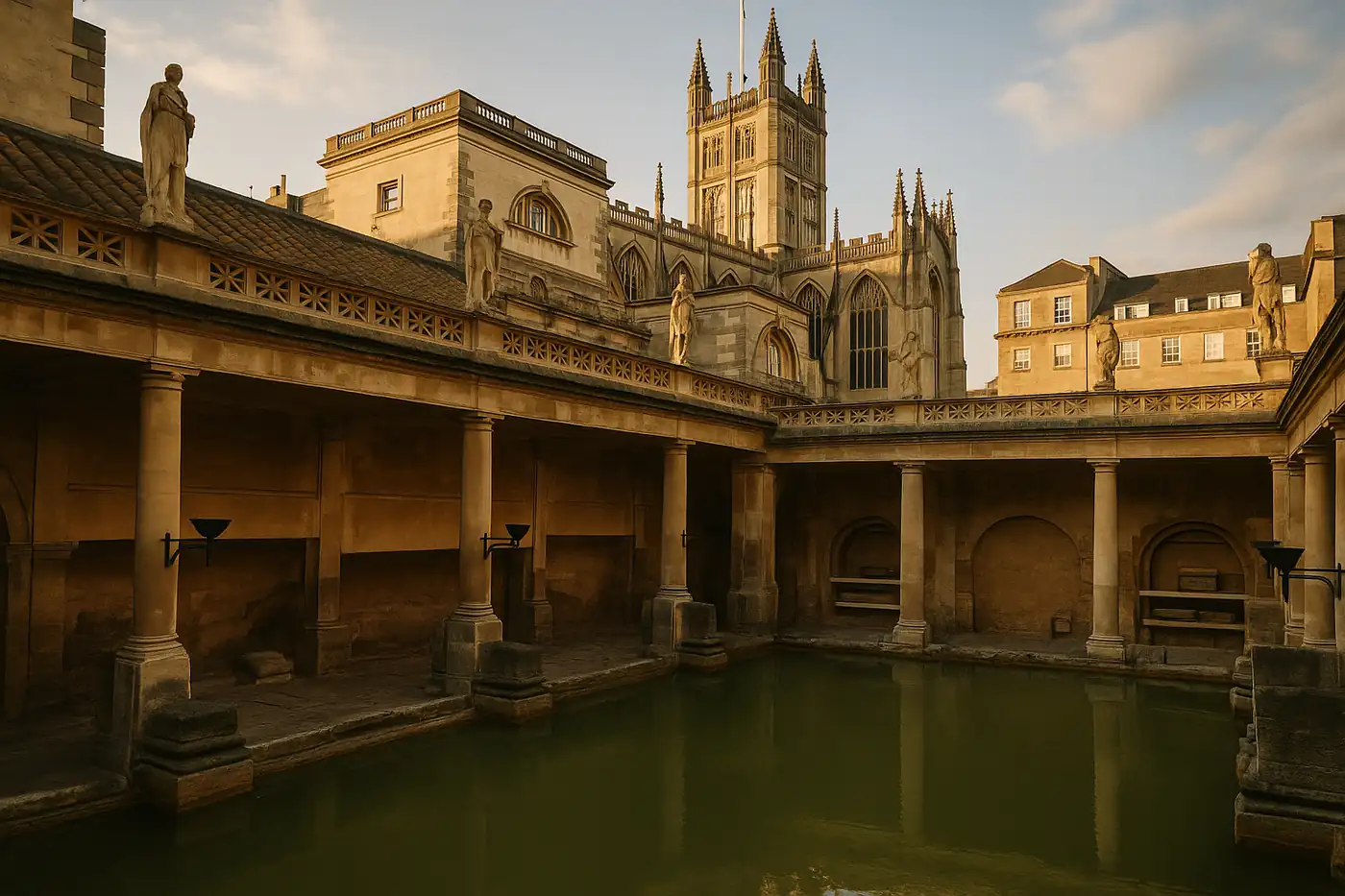
Roman Baths Bath Travel Guide 2026: Tickets, History, and Smart Visit Tips
Roman BritainPlan a better visit to the Roman Baths in Bath with clear ticket strategy, historical context, and p...
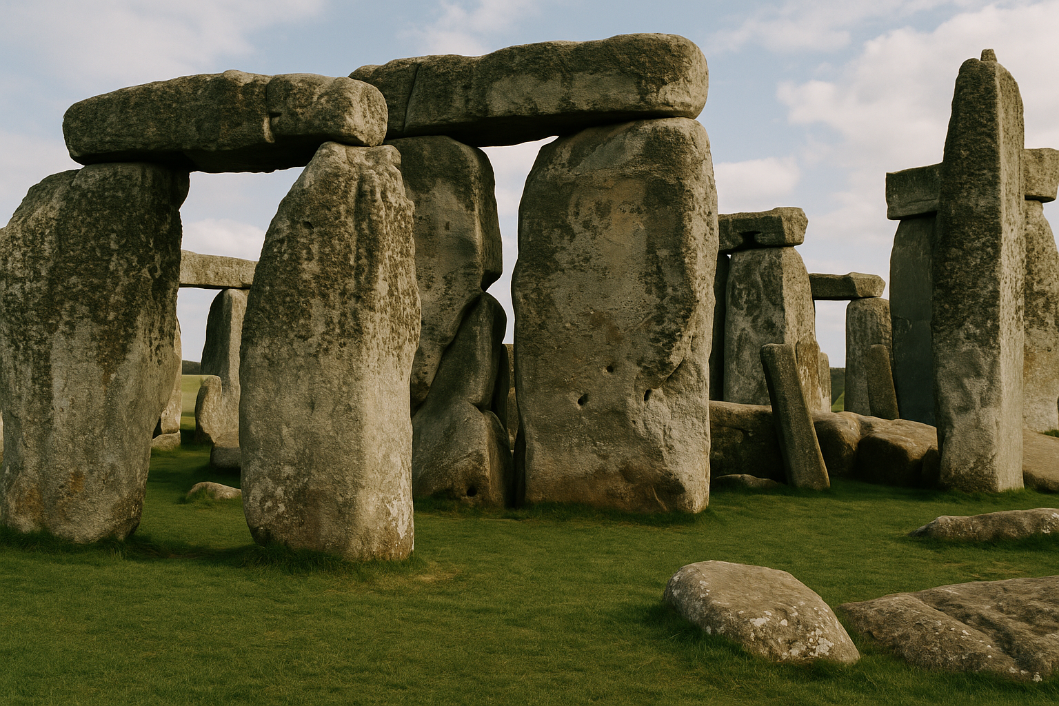
Stonehenge Travel Guide 2026: Solstice History, Tickets, and Day-Trip Planning
Neolithic and Bronze Age BritainPlan a smooth visit to Stonehenge with practical ticket timing, transport options from London and Ba...
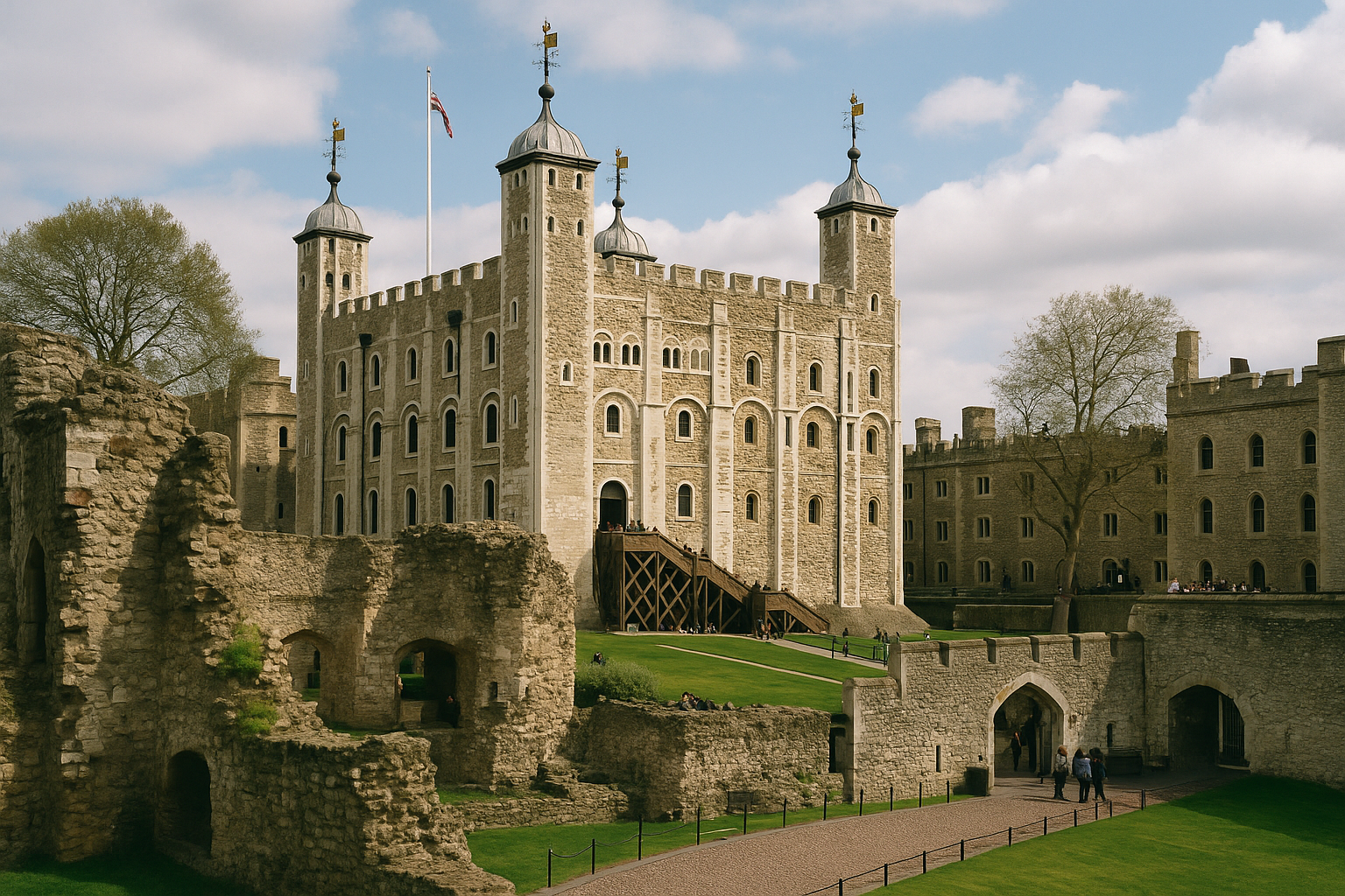
Tower of London Travel Guide 2026: Crown Jewels, History, and Visit Strategy
Norman and Medieval EnglishPlan a smart visit to the Tower of London with practical timing tips, must-see highlights, ticket st...