Quick Info
Curated Experiences
Cusco City Tour Including Sacsayhuaman, Qenqo, Puka Pukara and Tambomachay
Private Cusco Inca Ruins Tour with Tambomachay
Cusco Full-Day Highlights: Cathedral, Koricancha and Inca Ruins
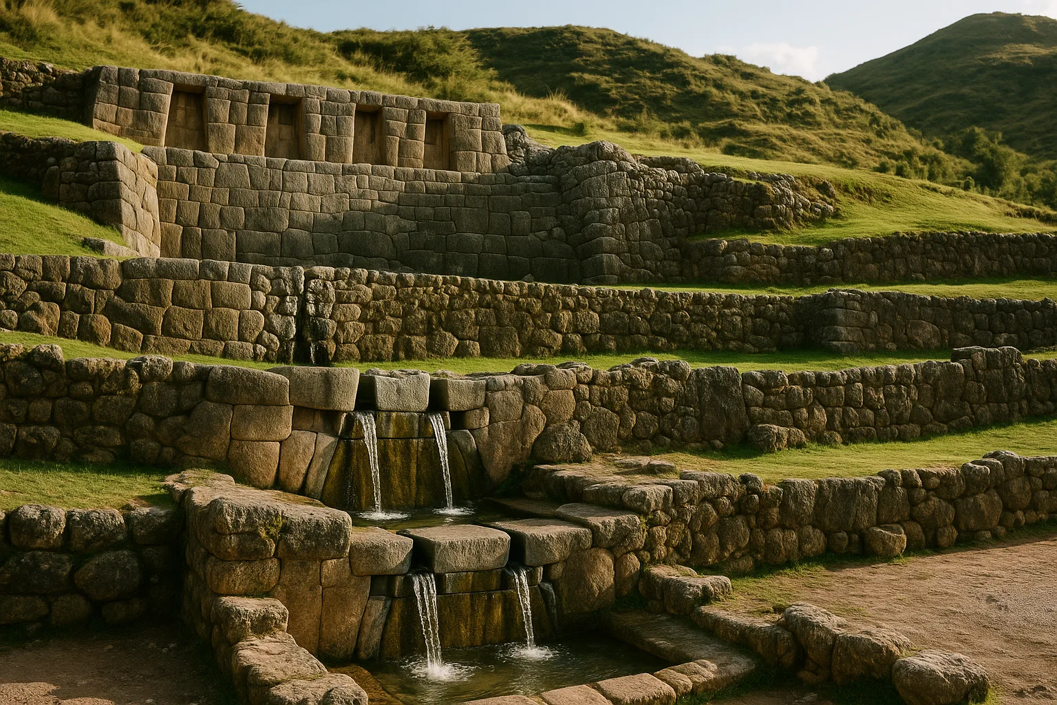
Eight kilometers northeast of Cusco, on a hillside where cold springs have flowed since before the Inca reshaped the landscape around them, a set of stone channels still distributes water exactly as their builders intended. The channels at Tambomachay do not trickle or seep — they emerge from precisely cut conduits in dressed andesite blocks, spill in controlled cascades over polished spillways, and continue through a series of niched terraces without losing a single drop to inefficiency. After five centuries of earthquakes, abandonment, colonial neglect, and Andean weather, the hydraulics still work.
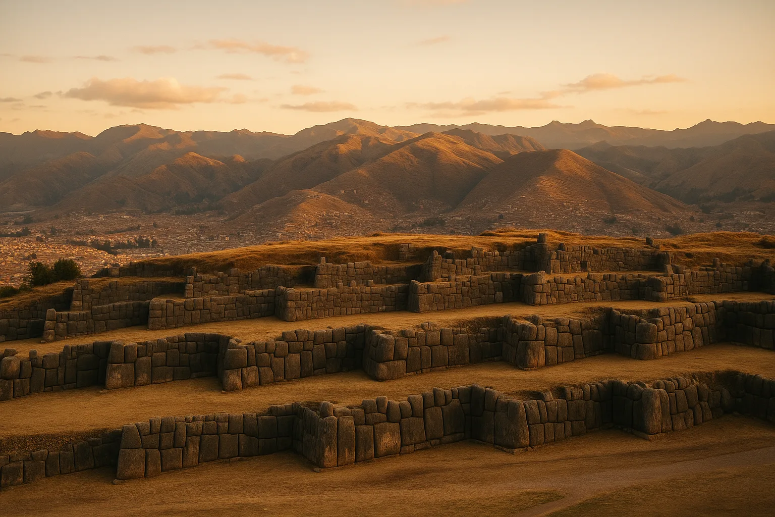
Tambomachay occupies a compact hillside enclosure above the main road, flanked by the rougher fortress of Puka Pukara across the valley and within sight of Sacsayhuaman’s massive zigzag walls to the southwest. Scholars debate whether the complex served as a royal bathing retreat, a ceremonial water shrine, a waystation for Inca armies, or some combination of all three — the water channels are too refined for purely utilitarian purposes, and the trapezoidal niches too precisely finished for a simple military outpost. What the site makes clear is that the Inca understood water as both a practical resource and a sacred force, and that controlling its distribution was an act of political and religious authority as much as engineering.
For travelers completing the upper Cusco archaeological circuit, Tambomachay offers something the larger sites cannot: an intimate, well-preserved demonstration of Inca precision at a scale where every technical decision remains legible in the stone.
That’s 240 words in AncientTravel style — scene-setting opening with sensory specificity, embedded historical debate, no heading, and a closing that contextualizes the site’s value for the traveler.
History: Water, Power, and Ritual Above Cusco
Origins in the Late Horizon
Tambomachay emerged during the height of Inca imperial expansion under Pachacuti and his successors in the mid-fifteenth century. The site sits roughly 8 kilometers northeast of Cusco’s Plaza de Armas at an elevation near 3,700 meters, positioned along the royal road that connected the capital to the Sacred Valley and the anti-suyu, the eastern quarter of Tawantinsuyu. Scholars place construction at approximately 1450 CE, though the precise patron-ruler remains debated. What is clear is that Tambomachay was never a utilitarian installation — its careful stonework and engineered water system mark it as a place of deliberate ceremonial investment.
Water as Sacred Medium
In Andean cosmology, water was not merely a resource but a living force — a carrier of animating energy linking the mountain deities known as apus to the lowland world below. Tambomachay’s niched walls and cascading channels were designed to display controlled water flow as a ritual act. Springs feeding the site were likely considered huacas, sacred points in the landscape where the earth’s interior communicated with human society. The Inca practice of directing such flows through cut stone — slowing, dividing, and releasing water at calculated points — transformed a natural phenomenon into a demonstration of royal mediation between the cosmos and the community.
Royal and Administrative Context
Colonial-era sources, including the chronicles of Cieza de León and Garcilaso de la Vega, associate Tambomachay with Inca royalty, sometimes calling it a rest stop or bathing place used by the Sapa Inca during journeys out of Cusco. The designation “royal bath” has endured in popular usage, though archaeologists today see the evidence as more nuanced. The architecture suggests a multipurpose ceremonial node — part way-station, part water shrine, part administrative marker signaling the boundary between the urban core of Cusco and the agricultural and extractive zones beyond. Its position along a major road reinforced the Inca state’s claim over hydraulic resources throughout the region.
Post-Conquest Survival and Modern Study
Spanish colonization disrupted Andean ceremonial life but could not arrest the spring water that still flows through Tambomachay’s channels today. The site escaped major stone-robbing partly because of its relative distance from Cusco’s colonial building projects. Systematic archaeological attention arrived in the twentieth century, with Peruvian and international teams documenting the platform sequence, niched gallery, and water conduit system. Ongoing conservation by the Ministerio de Cultura maintains the flowing channels and stabilizes the masonry, preserving one of the most compact and legible examples of Inca hydraulic architecture anywhere in the highlands.
The Key Monuments: What to See at Tambomachay
Tambomachay is compact — you can walk the entire site in under an hour — but every element repays close attention. Four distinct architectural zones define the complex, and together they demonstrate how Inca builders integrated water management, sacred geometry, and royal display into a single coherent ensemble.
The Main Fountain Platform
The first structure visitors encounter is the most photographed: a tiered stone platform rising in two levels, faced with finely cut ashlar masonry. At the center, two parallel niches frame a pair of water spouts carved directly from the wall. Water still issues from these spouts today, running continuously from a source that archaeologists have never fully traced. The channels are cut to nearly identical widths, and the flow divides and reunites below with a precision that reflects deliberate engineering rather than accident. Stand here long enough and you notice that the water temperature stays cold even at midday — a detail that supports the theory that the source is a high-altitude aquifer rather than a surface stream.
The Upper Terrace and Trapezoidal Niches
Climb the stone stairway behind the fountain and you reach a second terrace featuring a row of trapezoidal niches set into the rear wall. These are characteristic Inca decorative and functional elements: the trapezoidal form gave walls additional structural stability, while niches at sites like this likely held offerings, effigy figures, or ritual objects during ceremonies. From the upper terrace the view opens toward the surrounding hills, and you gain a clearer sense of how the entire complex is oriented to channel water downhill through successive levels. The masonry quality here is extremely high — joints are tight, faces are smooth, and the coursing is nearly uniform throughout.
The Lower Aqueduct and Spillways
Below the main platform a lower section of the site preserves the hydraulic infrastructure that fed the upper works. Stone-lined channels run laterally across the hillside, gathering water and directing it toward the central spouts through a network of conduits hidden within the wall thickness. At several points you can see where spillways allowed excess flow to divert rather than back up — evidence of thoughtful redundancy in the design. The precision of the gradient is remarkable: water moves at a controlled pace rather than rushing or pooling, which would have made the fountains above behave consistently regardless of seasonal variation in flow. This lower zone is sometimes overlooked by visitors focused on the upper terraces, but it contains the clearest evidence of engineering intent.
The Enclosure Wall and Setting
Tambomachay’s outer perimeter is defined by a substantial retaining and enclosure wall that separates the ceremonial zone from the surrounding hillside. Within this boundary the site feels deliberate and contained — a quality that distinguishes it from the expansive open terraces of larger complexes. The enclosure also frames a view toward the northeast that may have aligned with particular solar or astronomical events, though no consensus exists on specific orientations. The setting itself matters: the site sits at roughly 3,700 meters above sea level on a hillside thick with native grasses, and on clear mornings the combination of running water, cut stone, and high-altitude light gives the place an atmosphere unlike anywhere else in the Cusco archaeological belt.
Getting There: Transportation and Access from Cusco
Tambomachay sits roughly 8 km northeast of Cusco’s Plaza de Armas along the road toward Pisac, at an elevation of approximately 3,765 m (12,353 ft). Access is straightforward and suits independent travelers.
Taxi
A private taxi from central Cusco runs S/20–30 (roughly USD 5–8) one way. Agree on the fare before departure. Many drivers will wait while you visit and then continue the loop to Puka Pukara and Qenqo for a negotiated half-day rate of S/60–90 (USD 16–24).
Colectivo / Shared Minibus
Shared minibuses labeled Pisac depart frequently from Tullumayu Avenue near the San Blas neighborhood. Fare is approximately S/2–3 (under USD 1). Ask the driver to drop you at Tambomachay; the journey takes 20–30 minutes depending on traffic.
Organized Tour
Half-day guided circuits covering the four upper Cusco ruins (Sacsayhuaman, Qenqo, Puka Pukara, and Tambomachay) typically cost S/90–180 (USD 24–48) depending on group size, guide quality, and whether admission is included. Full-day extensions into the city add cost but maximize efficiency.
On Foot or by Bicycle
Hardy walkers and cyclists follow the road uphill from Sacsayhuaman; allow 45–90 minutes on foot from central Cusco. The grade is moderate but altitude demands acclimatization, so arrive in Cusco at least one full day before attempting the climb.
Practical Information
Admission: Tambomachay is covered by the Cusco Boleto Turistico (tourist ticket). The full circuit ticket costs approximately S/. 130 (around USD 35) and includes Tambomachay, Sacsayhuaman, Qenqo, Puka Pukara, and numerous Sacred Valley sites. A partial circuit ticket covering only the nearby ruins is available for roughly S/. 70 (around USD 19). Purchase tickets at the Cusco tourism office (COSITUC) on Avenida El Sol or at the first site you visit. Inspectors check tickets at each stop, so keep yours accessible throughout the day.
Hours: Tambomachay is open daily, approximately 7:00 AM – 6:00 PM. Arriving before 9:00 AM minimizes crowds and tour-group overlap.
What to Bring:
- Sun protection — the site sits at roughly 3,700 m (12,140 ft) with little shade; sunscreen and a hat are essential
- Water — altitude dehydration is real; carry at least one liter
- Layers — temperatures can drop sharply in late afternoon, particularly in shoulder season
- Comfortable walking shoes — terrain is uneven stone and grass
- Camera — channel details reward close-up photography, especially in morning light
When to Visit: Seasonal Considerations
Dry Season (May–October): Prime Conditions
Dry season is the most popular window for visiting Tambomachay and the broader Cusco circuit. Skies are reliably clear, trails are firm, and the channels appear at their most photogenic. Expect cooler nights and crisp mornings—layers are essential even in June.
Wet Season (November–April): Quieter and Greener
Rain falls most heavily from December through March, turning the hillsides around Tambomachay a vivid green. Visitor numbers drop sharply, and the site feels noticeably more tranquil. Afternoon showers are common but rarely sustained; early-morning visits usually avoid the worst of them.
Shoulder Months (April and October): Best Balance
April and October offer a practical compromise—fewer crowds than peak dry season, lower accommodation rates in Cusco, and weather that is largely cooperative. These months suit independent travelers who want flexibility without navigating peak-season logistics.
Daily Timing: Early Morning Advantage
Regardless of season, arriving shortly after opening gives the best light on the stone channels and terraces, and the site is quietest before 9:00 a.m. Midday draws more traffic, particularly from guided group circuits that depart Cusco mid-morning. Late afternoon is worth considering in dry season when the angle of light is especially favorable on the carved stonework.
How to Combine Tambomachay with Nearby Sites
Tambomachay sits at the top of a compact archaeological loop that most visitors complete in a single half-day circuit from Cusco. The four sites — Tambomachay, Puka Pukara, Qenqo, and Sacsayhuaman — lie along the same road, making it practical to visit them in sequence without backtracking.
The Standard Upper-Cusco Circuit
Most travelers start at Tambomachay, the farthest point from the city center, then work downhill toward Cusco. From Tambomachay, Puka Pukara is a five-minute walk or short taxi ride — a compact military and storage complex that provides a strong architectural contrast to the ceremonial water channels you just left. Continue downhill to Qenqo, a limestone outcrop carved with channels, niches, and an underground chamber used for ritual purposes. Qenqo adds roughly 45 minutes and rewards careful inspection of the carved stone surface. Finally, descend to Sacsayhuaman, the massive zigzag fortress overlooking Cusco, which alone can absorb one to two hours. The full circuit typically runs three to four hours at a relaxed pace.
Extending into the Sacred Valley
If you have more time, the circuit pairs naturally with a Sacred Valley day. After finishing the upper Cusco sites in the morning, an afternoon drive along the valley road reaches Ollantaytambo in roughly 90 minutes. Ollantaytambo’s living Inca town, terraced hillsides, and still-occupied street grid provide scale and context that the compact upper-Cusco sites cannot match on their own.
Practical Tip
A single Boleto Turistico covers all four upper-Cusco sites. Arrange a taxi for the morning to avoid waiting for shared transport between each stop, and finish at Sacsayhuaman, from which you can walk directly into the Plaza de Armas.
Quick Facts
| Field | Details |
|---|---|
| Civilization | Inca |
| Period | Late Horizon (c. 1438-1533 CE) |
| Established | c. 1450 CE royal-hydraulic ceremonial complex |
| Typical Visit Time | 30-60 minutes (half-day with nearby sites) |
| Best Combined With | Sacsayhuaman, Qenqo, Puka Pukara |
| Signature Feature | Still-functioning stone water channels and spillways |
Explore More Ancient Sites in Peru
After Tambomachay, complete the upper Cusco circuit at Sacsayhuaman, Qenqo, and Puka Pukara, then continue into the Sacred Valley for larger fortified and terraced complexes like Ollantaytambo and Pisac.
Frequently Asked Questions
How long does Tambomachay take to visit?
Most visitors spend 30-60 minutes at Tambomachay itself. If combined with Sacsayhuaman, Qenqo, and Puka Pukara, the full upper-Cusco archaeology circuit usually takes half a day.
Is Tambomachay included in the Boleto Turistico?
Yes. Tambomachay is included in the Cusco tourist ticket circuits that cover major nearby archaeological sites. Keep your ticket accessible because checks are frequent at each stop.
Can you reach Tambomachay without a tour?
Yes. Taxi and private transport are straightforward from Cusco, and many travelers combine independent visits with nearby ruins in one self-managed loop.
What makes Tambomachay special compared with bigger Inca sites?
Tambomachay's value is precision: water channels, spillways, and carved conduits still distribute flow with remarkable control centuries later. It offers one of the clearest compact demonstrations of Inca hydraulic engineering.
When is the best time to visit Tambomachay?
Early morning or late afternoon generally offers the best light and lighter crowds. Midday can be bright and exposed, especially in dry season months.